Wilderness Topo Map Missouri
To zoom in, hover over the map of Wilderness
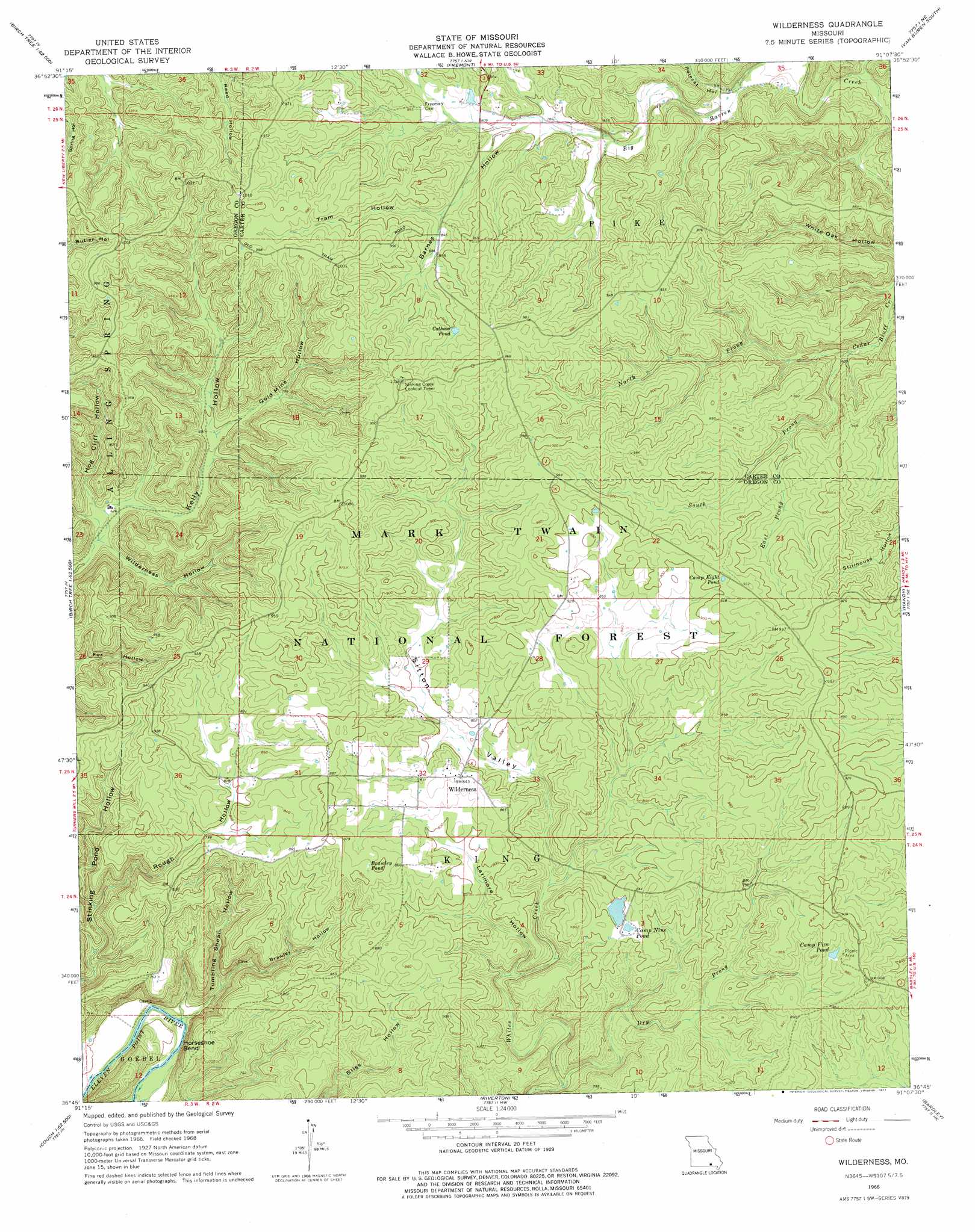
USGS Topo Quad 36091g2 - 1:24,000 scale
| Topo Map Name: | Wilderness |
| USGS Topo Quad ID: | 36091g2 |
| Print Size: | ca. 21 1/4" wide x 27" high |
| Southeast Coordinates: | 36.75° N latitude / 91.125° W longitude |
| Map Center Coordinates: | 36.8125° N latitude / 91.1875° W longitude |
| U.S. State: | MO |
| Filename: | o36091g2.jpg |
| Download Map JPG Image: | Wilderness topo map 1:24,000 scale |
| Map Type: | Topographic |
| Topo Series: | 7.5´ |
| Map Scale: | 1:24,000 |
| Source of Map Images: | United States Geological Survey (USGS) |
| Alternate Map Versions: |
Wilderness MO 1968, updated 1969 Download PDF Buy paper map Wilderness MO 1968, updated 1977 Download PDF Buy paper map Wilderness MO 1997, updated 1999 Download PDF Buy paper map Wilderness MO 2012 Download PDF Buy paper map Wilderness MO 2015 Download PDF Buy paper map |
| FStopo: | US Forest Service topo Wilderness is available: Download FStopo PDF Download FStopo TIF |
1:24,000 Topo Quads surrounding Wilderness
Bartlett |
Winona |
Stegall Mountain |
Van Buren North |
Garwood |
Birch Tree |
Low Wassie |
Fremont |
Van Buren South |
Big Spring |
Peidmont Hollow |
Greer |
Wilderness |
Handy |
Grandin Sw |
Alton |
Many Springs |
Riverton |
Bardley |
Briar |
Conch |
Myrtle |
Billmore |
Gatewood |
Poynor |
> Back to 36091e1 at 1:100,000 scale
> Back to 36090a1 at 1:250,000 scale
> Back to U.S. Topo Maps home
Wilderness topo map: Gazetteer
Wilderness: Bends
Horseshoe Bend elevation 157m 515′Wilderness: Dams
Taylor Lake Dam elevation 236m 774′Wilderness: Forests
Winona - Doniphan - Van Buren Ranger Districts elevation 247m 810′Wilderness: Lakes
Brawley Pond elevation 272m 892′Camp Eight Pond elevation 279m 915′
Camp Five Pond elevation 261m 856′
Cotham Pond elevation 278m 912′
Wilderness: Populated Places
Wilderness elevation 256m 839′Wilderness: Reservoirs
Camp Nine Pond elevation 236m 774′Wilderness: Springs
Spout Spring elevation 206m 675′Wilderness: Streams
Dry Prong elevation 180m 590′East Prong Cedar Bluff Creek elevation 231m 757′
North Prong Cedar Bluff Creek elevation 208m 682′
South Prong Cedar Bluff Creek elevation 208m 682′
Wilderness: Valleys
Barnes Hollow elevation 243m 797′Black Hollow elevation 150m 492′
Brawley Hollow elevation 166m 544′
Gold Mine Hollow elevation 210m 688′
Hog Cliff Hollow elevation 191m 626′
Larimore Hollow elevation 208m 682′
Polecat Hollow elevation 224m 734′
Rough Hollow elevation 177m 580′
Sitton Valley elevation 231m 757′
Tram Hollow elevation 256m 839′
Tumbling Shoal Hollow elevation 146m 479′
Wilderness Hollow elevation 187m 613′
Wilderness digital topo map on disk
Buy this Wilderness topo map showing relief, roads, GPS coordinates and other geographical features, as a high-resolution digital map file on DVD: