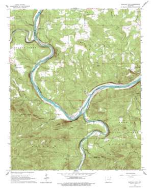
Buffalo City Topo Map Arkansas
To zoom in, hover over the map of Buffalo City
USGS Topo Quad 36092b4 - 1:24,000 scale
| Topo Map Name: | Buffalo City |
| USGS Topo Quad ID: | 36092b4 |
| Print Size: | ca. 21 1/4" wide x 27" high |
| Southeast Coordinates: | 36.125° N latitude / 92.375° W longitude |
| Map Center Coordinates: | 36.1875° N latitude / 92.4375° W longitude |
| U.S. State: | AR |
| Filename: | o36092b4.jpg |
| Download Map JPG Image: | Buffalo City topo map 1:24,000 scale |
| Map Type: | Topographic |
| Topo Series: | 7.5´ |
| Map Scale: | 1:24,000 |
| Source of Map Images: | United States Geological Survey (USGS) |
| Alternate Map Versions: |
Buffalo City AR 1966, updated 1967 Download PDF Buy paper map Buffalo City AR 1966, updated 1977 Download PDF Buy paper map Buffalo City AR 1966, updated 1977 Download PDF Buy paper map Buffalo City AR 2011 Download PDF Buy paper map Buffalo City AR 2014 Download PDF Buy paper map |
| FStopo: | US Forest Service topo Buffalo City is available: Download FStopo PDF Download FStopo TIF |
1:24,000 Topo Quads surrounding Buffalo City
> Back to 36092a1 at 1:100,000 scale
> Back to 36092a1 at 1:250,000 scale
> Back to U.S. Topo Maps home
Buffalo City topo map: Gazetteer
Buffalo City: Bars
Campbells Shoal elevation 117m 383′Cow Rock Shoals elevation 117m 383′
Tinnan Rock Shoals elevation 118m 387′
Buffalo City: Bays
Gin Eddy elevation 118m 387′Buffalo City: Bends
Hudsons Bend elevation 115m 377′Buffalo City: Channels
Shields Chute elevation 118m 387′Buffalo City: Cliffs
Crystal Point elevation 322m 1056′Lone Rock elevation 187m 613′
Stair Bluff elevation 207m 679′
Buffalo City: Crossings
Birds Ford elevation 116m 380′Goodmans Ford elevation 114m 374′
Nelsons Ferry (historical) elevation 111m 364′
Buffalo City: Populated Places
Advance elevation 195m 639′Buffalo City elevation 134m 439′
Buford elevation 213m 698′
Cartney elevation 126m 413′
Hand Valley elevation 211m 692′
Laytonville (historical) elevation 224m 734′
Old Buffalo elevation 145m 475′
Buffalo City: Ridges
Hoodlum Ridge elevation 248m 813′Buffalo City: Springs
Fox Den Spring elevation 156m 511′Buffalo City: Streams
Brush Creek elevation 127m 416′Buffalo River elevation 112m 367′
Cockran Creek elevation 129m 423′
Cow Creek elevation 117m 383′
Crooked Creek elevation 117m 383′
Cunningham Creek elevation 112m 367′
Dry Creek elevation 118m 387′
Gosha Creek elevation 117m 383′
Laffoon Creek elevation 128m 419′
Nelson Creek elevation 111m 364′
Perry Creek elevation 111m 364′
Running Fork elevation 154m 505′
Stewart Creek elevation 116m 380′
Terrapin Creek elevation 152m 498′
Warner Creek elevation 117m 383′
Warrior Creek elevation 160m 524′
Williams Creek elevation 151m 495′
Buffalo City: Summits
Cleveland Knob elevation 353m 1158′Fletcher Mountain elevation 308m 1010′
Granite Mountain elevation 344m 1128′
Hand Mountain elevation 277m 908′
Hathaway Mountain elevation 348m 1141′
Hip Mountain elevation 290m 951′
Lion Hill elevation 343m 1125′
Perry Knob elevation 334m 1095′
Prince Fred Knob elevation 361m 1184′
Turkey Knob elevation 282m 925′
Turkey Mountain elevation 328m 1076′
Warrior Creek Mountain elevation 368m 1207′
Buffalo City: Valleys
Cook Hollow elevation 113m 370′Elm Hollow elevation 117m 383′
Hathaway Hollow elevation 129m 423′
Holsey Hollow elevation 165m 541′
Steep Gully elevation 112m 367′
Trimble Hollow elevation 128m 419′
Buffalo City digital topo map on disk
Buy this Buffalo City topo map showing relief, roads, GPS coordinates and other geographical features, as a high-resolution digital map file on DVD:


