Bull Shoals Topo Map Arkansas
To zoom in, hover over the map of Bull Shoals
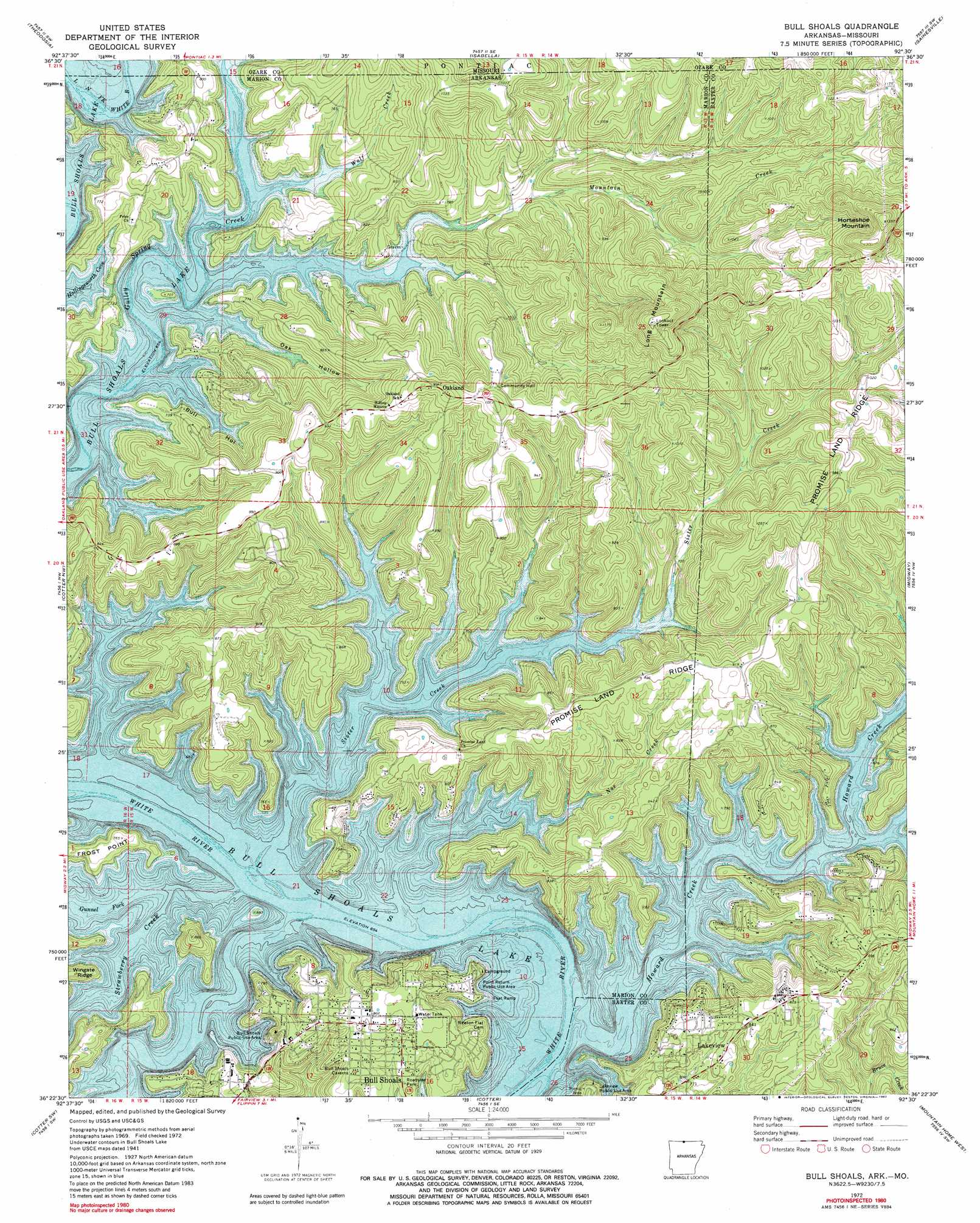
USGS Topo Quad 36092d5 - 1:24,000 scale
| Topo Map Name: | Bull Shoals |
| USGS Topo Quad ID: | 36092d5 |
| Print Size: | ca. 21 1/4" wide x 27" high |
| Southeast Coordinates: | 36.375° N latitude / 92.5° W longitude |
| Map Center Coordinates: | 36.4375° N latitude / 92.5625° W longitude |
| U.S. States: | AR, MO |
| Filename: | o36092d5.jpg |
| Download Map JPG Image: | Bull Shoals topo map 1:24,000 scale |
| Map Type: | Topographic |
| Topo Series: | 7.5´ |
| Map Scale: | 1:24,000 |
| Source of Map Images: | United States Geological Survey (USGS) |
| Alternate Map Versions: |
Bull Shoals AR 1972, updated 1973 Download PDF Buy paper map Bull Shoals AR 1972, updated 1982 Download PDF Buy paper map Bull Shoals AR 1972, updated 1982 Download PDF Buy paper map Bull Shoals AR 1979, updated 1981 Download PDF Buy paper map Bull Shoals AR 2011 Download PDF Buy paper map Bull Shoals AR 2014 Download PDF Buy paper map |
1:24,000 Topo Quads surrounding Bull Shoals
Protem Ne |
Thornfield |
Willhoit |
Gainesville Nw |
Sycamore |
Protem |
Theodosia |
Isabella |
Gainesville |
Udall |
Peel |
Cotter Nw |
Bull Shoals |
Midway |
Clarkridge |
Pyatt |
Cotter Sw |
Cotter |
Mountain Home West |
Mountain Home East |
Bruno |
Yellville |
Rea Valley |
Buffalo City |
Norfork |
> Back to 36092a1 at 1:100,000 scale
> Back to 36092a1 at 1:250,000 scale
> Back to U.S. Topo Maps home
Bull Shoals topo map: Gazetteer
Bull Shoals: Crossings
Pace Ferry (historical) elevation 190m 623′Bull Shoals: Parks
Bull Shoals Public Use Area elevation 198m 649′Lakeview Public Use Area elevation 224m 734′
Point Return Public Use Area elevation 196m 643′
Bull Shoals: Populated Places
Bull Shoals elevation 240m 787′Oakland elevation 319m 1046′
Price Place elevation 249m 816′
Bull Shoals: Ridges
Promise Land Ridge elevation 293m 961′Bull Shoals: Streams
Dry Run (historical) elevation 193m 633′Gunnel Fork elevation 192m 629′
Howard Creek elevation 193m 633′
Mountain Creek elevation 197m 646′
Noe Creek elevation 197m 646′
Sister Creek elevation 191m 626′
Strawberry Creek elevation 191m 626′
Wolf Creek elevation 195m 639′
Bull Shoals: Summits
Horseshoe Mountain elevation 410m 1345′Long Mountain elevation 396m 1299′
Bull Shoals: Valleys
Bull Hollow elevation 195m 639′Oak Hollow elevation 195m 639′
Bull Shoals digital topo map on disk
Buy this Bull Shoals topo map showing relief, roads, GPS coordinates and other geographical features, as a high-resolution digital map file on DVD: