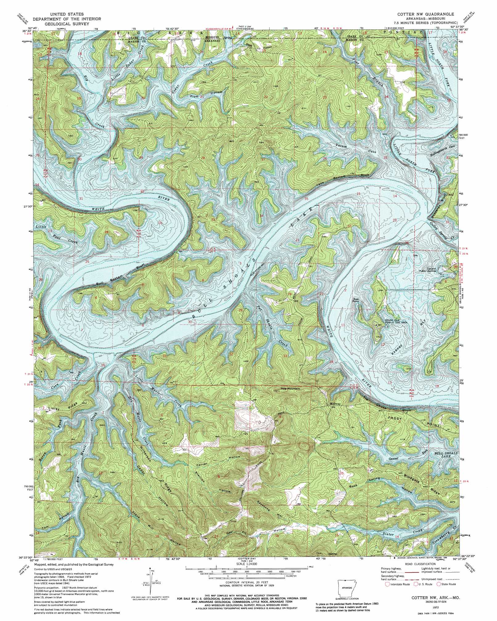
Cotter Nw Topo Map Arkansas
To zoom in, hover over the map of Cotter Nw
USGS Topo Quad 36092d6 - 1:24,000 scale
| Topo Map Name: | Cotter Nw |
| USGS Topo Quad ID: | 36092d6 |
| Print Size: | ca. 21 1/4" wide x 27" high |
| Southeast Coordinates: | 36.375° N latitude / 92.625° W longitude |
| Map Center Coordinates: | 36.4375° N latitude / 92.6875° W longitude |
| U.S. States: | AR, MO |
| Filename: | o36092d6.jpg |
| Download Map JPG Image: | Cotter Nw topo map 1:24,000 scale |
| Map Type: | Topographic |
| Topo Series: | 7.5´ |
| Map Scale: | 1:24,000 |
| Source of Map Images: | United States Geological Survey (USGS) |
| Alternate Map Versions: |
Cotter NW AR 1972, updated 1973 Download PDF Buy paper map Cotter NW AR 1972, updated 1986 Download PDF Buy paper map Cotter NW AR 1979, updated 1981 Download PDF Buy paper map Cotter NW AR 2011 Download PDF Buy paper map Cotter NW AR 2014 Download PDF Buy paper map |
1:24,000 Topo Quads surrounding Cotter Nw
Hilda |
Protem Ne |
Thornfield |
Willhoit |
Gainesville Nw |
Protem Sw |
Protem |
Theodosia |
Isabella |
Gainesville |
Diamond City |
Peel |
Cotter Nw |
Bull Shoals |
Midway |
Zinc |
Pyatt |
Cotter Sw |
Cotter |
Mountain Home West |
Everton |
Bruno |
Yellville |
Rea Valley |
Buffalo City |
> Back to 36092a1 at 1:100,000 scale
> Back to 36092a1 at 1:250,000 scale
> Back to U.S. Topo Maps home
Cotter Nw topo map: Gazetteer
Cotter Nw: Bays
Barnes Bay elevation 193m 633′Cotter Nw: Capes
Frost Point elevation 236m 774′Cotter Nw: Cliffs
Bull Bottom Bluff elevation 194m 636′Buzzard Bluff elevation 197m 646′
Cane Bottom Bluff elevation 197m 646′
Tie Chute Bluff elevation 241m 790′
Wilson Bluff elevation 193m 633′
Cotter Nw: Islands
Ozark Isle elevation 219m 718′Cotter Nw: Parks
Jones Point State Wildlife Management Area elevation 217m 711′Oakland Public Use Area elevation 206m 675′
Ozard Isle Public Use Area elevation 210m 688′
Ozark Isle Public Use Area elevation 229m 751′
Cotter Nw: Populated Places
Midway elevation 239m 784′Cotter Nw: Ridges
Wilkerson Ridge elevation 251m 823′Windgate Ridge elevation 245m 803′
Cotter Nw: Streams
Big Creek elevation 196m 643′Big Creek elevation 199m 652′
Big Music Creek elevation 194m 636′
Boren Fork elevation 192m 629′
Cedar Creek elevation 199m 652′
Cedar Creek elevation 196m 643′
Coon Creek elevation 193m 633′
Dry Music Creek elevation 190m 623′
Gulley Spring Creek elevation 196m 643′
Hollingsworth Cove elevation 196m 643′
Little Cedar Creek elevation 195m 639′
Little Fool Creek elevation 194m 636′
Little Music Creek elevation 194m 636′
Little North Fork White River elevation 195m 639′
Pine Branch elevation 199m 652′
Pot Shoals Creek elevation 194m 636′
Sister Creek elevation 193m 633′
Yocum Cove elevation 195m 639′
Cotter Nw: Summits
Pine Mountain elevation 349m 1145′Cotter Nw: Valleys
Buck Spring Hollow elevation 192m 629′Carver Hollow elevation 211m 692′
Cedar Hollow elevation 192m 629′
Coal Pit Hollow elevation 221m 725′
Dark Hollow elevation 202m 662′
Keystone Hollow elevation 221m 725′
Pine Hollow elevation 196m 643′
Plum Hollow elevation 196m 643′
Stallion Hollow elevation 211m 692′
Stave Mill Hollow elevation 192m 629′
Tom Hollow elevation 193m 633′
Cotter Nw digital topo map on disk
Buy this Cotter Nw topo map showing relief, roads, GPS coordinates and other geographical features, as a high-resolution digital map file on DVD: