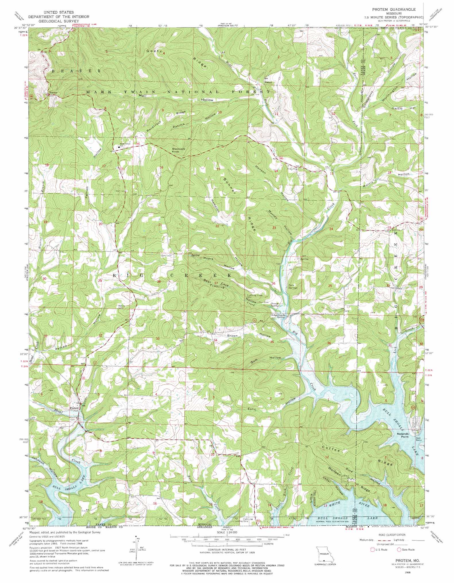
Protem Topo Map Missouri
To zoom in, hover over the map of Protem
USGS Topo Quad 36092e7 - 1:24,000 scale
| Topo Map Name: | Protem |
| USGS Topo Quad ID: | 36092e7 |
| Print Size: | ca. 21 1/4" wide x 27" high |
| Southeast Coordinates: | 36.5° N latitude / 92.75° W longitude |
| Map Center Coordinates: | 36.5625° N latitude / 92.8125° W longitude |
| U.S. State: | MO |
| Filename: | o36092e7.jpg |
| Download Map JPG Image: | Protem topo map 1:24,000 scale |
| Map Type: | Topographic |
| Topo Series: | 7.5´ |
| Map Scale: | 1:24,000 |
| Source of Map Images: | United States Geological Survey (USGS) |
| Alternate Map Versions: |
Protem MO 1968, updated 1969 Download PDF Buy paper map Protem MO 1968, updated 1976 Download PDF Buy paper map Protem MO 2004, updated 2006 Download PDF Buy paper map Protem MO 2012 Download PDF Buy paper map Protem MO 2015 Download PDF Buy paper map |
| FStopo: | US Forest Service topo Protem is available: Download FStopo PDF Download FStopo TIF |
1:24,000 Topo Quads surrounding Protem
Garrison |
Bradleyville |
Brownbranch |
Smallett |
Wasola |
Forsyth |
Hilda |
Protem Ne |
Thornfield |
Willhoit |
Mincy |
Protem Sw |
Protem |
Theodosia |
Isabella |
Omaha Ne |
Diamond City |
Peel |
Cotter Nw |
Bull Shoals |
Bergman |
Zinc |
Pyatt |
Cotter Sw |
Cotter |
> Back to 36092e1 at 1:100,000 scale
> Back to 36092a1 at 1:250,000 scale
> Back to U.S. Topo Maps home
Protem topo map: Gazetteer
Protem: Airports
Nolands Point Seaplane Base elevation 199m 652′Protem: Capes
Nolands Point elevation 216m 708′Protem: Populated Places
Nance elevation 269m 882′Ocie elevation 227m 744′
Protem elevation 214m 702′
Rueter elevation 399m 1309′
Protem: Ridges
Bonner Ridge elevation 288m 944′Coffee Ridge elevation 300m 984′
Goetz Ridge elevation 341m 1118′
Racetrack Ridge elevation 338m 1108′
Wolfpen Ridge elevation 268m 879′
Protem: Springs
Owens Spring elevation 212m 695′Schoolhouse Spring elevation 207m 679′
Twin Springs elevation 220m 721′
Protem: Streams
East Fork Big Creek elevation 220m 721′Lick Creek elevation 199m 652′
Tumbling Creek elevation 207m 679′
West Fork Big Creek elevation 220m 721′
Protem: Summits
Blackjack Knob elevation 361m 1184′Protem: Valleys
Bear Cave Hollow elevation 209m 685′Brown Hollow elevation 209m 685′
Cedar Hollow elevation 199m 652′
Eslic Hollow elevation 200m 656′
Goldsbarry Hollow elevation 228m 748′
Gum Hollow elevation 205m 672′
Hampton Hollow elevation 209m 685′
Harris Hollow elevation 237m 777′
Henson Hollow elevation 213m 698′
Johnson Hollow elevation 199m 652′
Little Cedar Hollow elevation 199m 652′
Mail Hollow elevation 233m 764′
Moore Hollow elevation 234m 767′
Morris Hollow elevation 219m 718′
Murley Hollow elevation 211m 692′
Patrick Hollow elevation 243m 797′
Pelham Hollow elevation 225m 738′
Worthington Hollow elevation 237m 777′
Protem digital topo map on disk
Buy this Protem topo map showing relief, roads, GPS coordinates and other geographical features, as a high-resolution digital map file on DVD: