Willhoit Topo Map Missouri
To zoom in, hover over the map of Willhoit
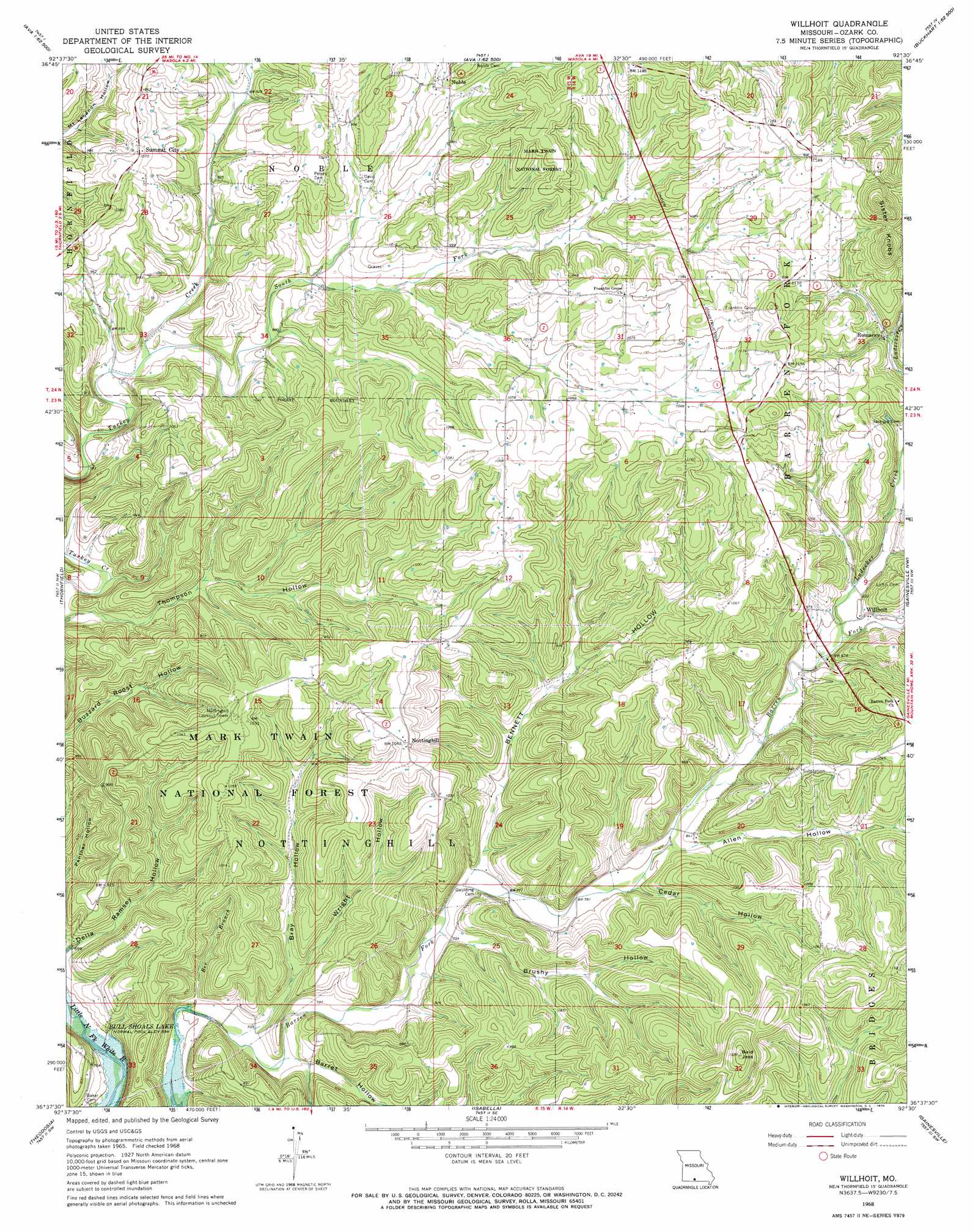
USGS Topo Quad 36092f5 - 1:24,000 scale
| Topo Map Name: | Willhoit |
| USGS Topo Quad ID: | 36092f5 |
| Print Size: | ca. 21 1/4" wide x 27" high |
| Southeast Coordinates: | 36.625° N latitude / 92.5° W longitude |
| Map Center Coordinates: | 36.6875° N latitude / 92.5625° W longitude |
| U.S. State: | MO |
| Filename: | o36092f5.jpg |
| Download Map JPG Image: | Willhoit topo map 1:24,000 scale |
| Map Type: | Topographic |
| Topo Series: | 7.5´ |
| Map Scale: | 1:24,000 |
| Source of Map Images: | United States Geological Survey (USGS) |
| Alternate Map Versions: |
Willhoit MO 1968, updated 1970 Download PDF Buy paper map Willhoit MO 2004, updated 2006 Download PDF Buy paper map Willhoit MO 2012 Download PDF Buy paper map Willhoit MO 2015 Download PDF Buy paper map |
| FStopo: | US Forest Service topo Willhoit is available: Download FStopo PDF Download FStopo TIF |
1:24,000 Topo Quads surrounding Willhoit
Goodhope |
Ava |
Sweden |
Brushyknob |
Vanzant |
Brownbranch |
Smallett |
Wasola |
Rockbridge |
Gentryville |
Protem Ne |
Thornfield |
Willhoit |
Gainesville Nw |
Sycamore |
Protem |
Theodosia |
Isabella |
Gainesville |
Udall |
Peel |
Cotter Nw |
Bull Shoals |
Midway |
Clarkridge |
> Back to 36092e1 at 1:100,000 scale
> Back to 36092a1 at 1:250,000 scale
> Back to U.S. Topo Maps home
Willhoit topo map: Gazetteer
Willhoit: Populated Places
Grabeel (historical) elevation 326m 1069′Noble elevation 318m 1043′
Nottinghill elevation 319m 1046′
Romance elevation 303m 994′
Summit City elevation 325m 1066′
Willhoit elevation 276m 905′
Willhoit: Post Offices
Grabel Post Office (historical) elevation 326m 1069′Willhoit: Ranges
Sister Knobs elevation 428m 1404′Willhoit: Streams
Bee Branch elevation 212m 695′Ludecker Creek elevation 268m 879′
South Fork Turkey Creek elevation 253m 830′
Willhoit: Summits
Bald Jess elevation 404m 1325′Willhoit: Valleys
Allen Hollow elevation 245m 803′Barret Hollow elevation 232m 761′
Bennett Hollow elevation 234m 767′
Bray Hollow elevation 219m 718′
Brushy Hollow elevation 233m 764′
Cedar Hollow elevation 241m 790′
Della Ramsey Hollow elevation 214m 702′
Wright Hollow elevation 227m 744′
Willhoit digital topo map on disk
Buy this Willhoit topo map showing relief, roads, GPS coordinates and other geographical features, as a high-resolution digital map file on DVD: