Spring Valley Topo Map Arkansas
To zoom in, hover over the map of Spring Valley
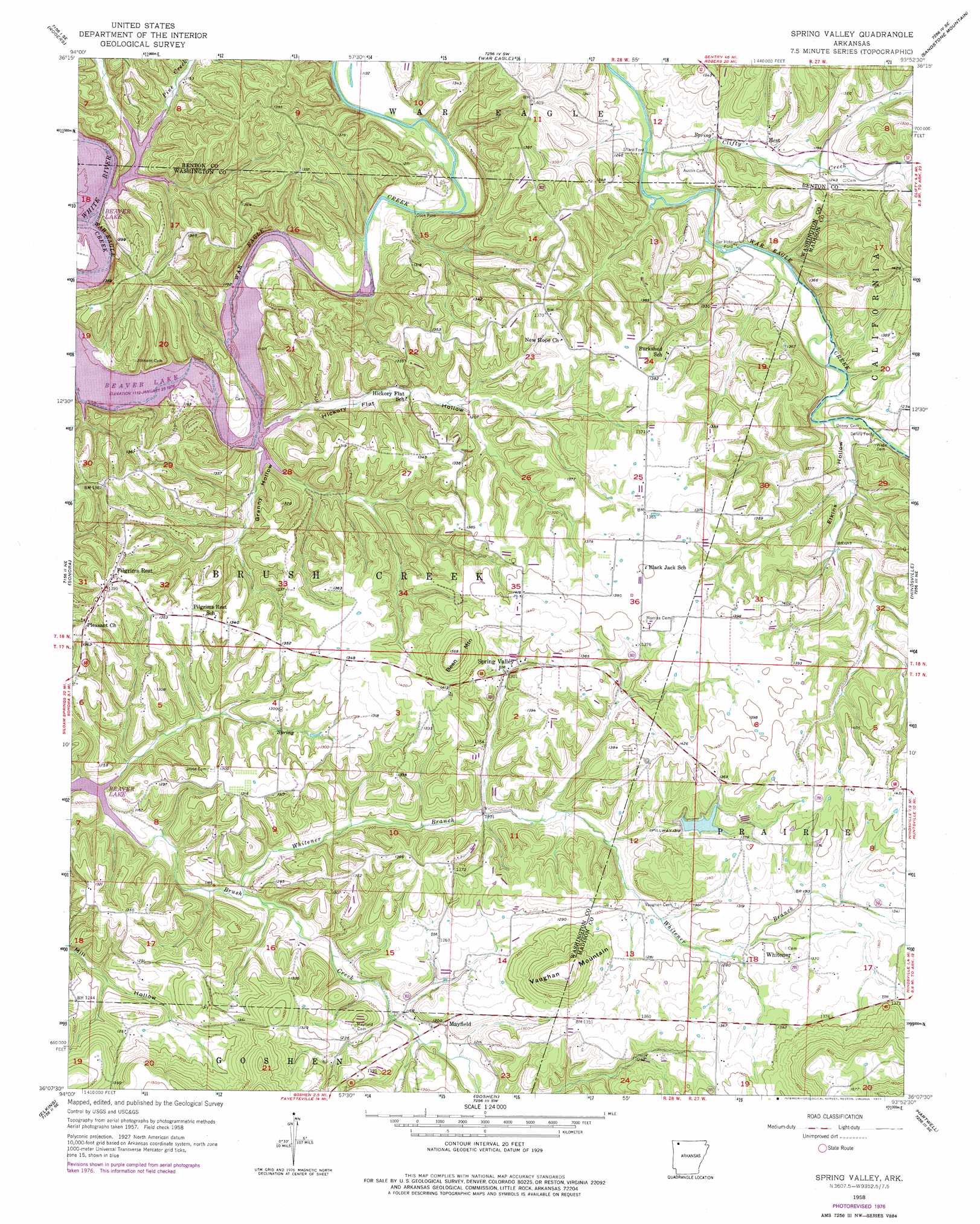
USGS Topo Quad 36093b8 - 1:24,000 scale
| Topo Map Name: | Spring Valley |
| USGS Topo Quad ID: | 36093b8 |
| Print Size: | ca. 21 1/4" wide x 27" high |
| Southeast Coordinates: | 36.125° N latitude / 93.875° W longitude |
| Map Center Coordinates: | 36.1875° N latitude / 93.9375° W longitude |
| U.S. State: | AR |
| Filename: | o36093b8.jpg |
| Download Map JPG Image: | Spring Valley topo map 1:24,000 scale |
| Map Type: | Topographic |
| Topo Series: | 7.5´ |
| Map Scale: | 1:24,000 |
| Source of Map Images: | United States Geological Survey (USGS) |
| Alternate Map Versions: |
Spring Valley AR 1958, updated 1959 Download PDF Buy paper map Spring Valley AR 1958, updated 1967 Download PDF Buy paper map Spring Valley AR 1958, updated 1977 Download PDF Buy paper map Spring Valley AR 2011 Download PDF Buy paper map Spring Valley AR 2014 Download PDF Buy paper map |
1:24,000 Topo Quads surrounding Spring Valley
Bentonville North |
Pea Ridge |
Garfield |
Beaver |
Eureka Springs |
Bentonville South |
Rogers |
War Eagle |
Sandstone Mountain |
Rockhouse |
Springdale |
Sonora |
Spring Valley |
Hindsville |
Forum |
Fayettville |
Elkins |
Goshen |
Hartwell |
Huntsville |
West Fork |
Sulphur City |
Durham |
Japton |
Witter |
> Back to 36093a1 at 1:100,000 scale
> Back to 36092a1 at 1:250,000 scale
> Back to U.S. Topo Maps home
Spring Valley topo map: Gazetteer
Spring Valley: Cliffs
Martin Bluff elevation 361m 1184′Spring Valley: Crossings
Cook Ford elevation 342m 1122′Denny Ford elevation 353m 1158′
Ellis Ford (historical) elevation 342m 1122′
Sharp Ford elevation 352m 1154′
Spring Valley: Dams
Hindsville Lake Dam elevation 410m 1345′Spring Valley: Populated Places
Cottage Hill (historical) elevation 378m 1240′Mayfield elevation 370m 1213′
Pilgrims Rest elevation 425m 1394′
Spring Valley elevation 398m 1305′
War Eagle Cove elevation 353m 1158′
Whitener elevation 395m 1295′
Spring Valley: Reservoirs
Hindsville Lake elevation 410m 1345′Spring Valley: Streams
Brush Creek elevation 342m 1122′Clifty Creek elevation 357m 1171′
Pine Creek elevation 346m 1135′
War Eagle Creek elevation 345m 1131′
Whitener Branch elevation 344m 1128′
Spring Valley: Summits
Been Mountain elevation 476m 1561′Vaughan Mountain elevation 473m 1551′
Spring Valley: Valleys
Elkins Hollow elevation 362m 1187′Granny Hollow elevation 342m 1122′
Hickory Flat Hollow elevation 342m 1122′
Spring Valley digital topo map on disk
Buy this Spring Valley topo map showing relief, roads, GPS coordinates and other geographical features, as a high-resolution digital map file on DVD: