Beaver Topo Map Arkansas
To zoom in, hover over the map of Beaver
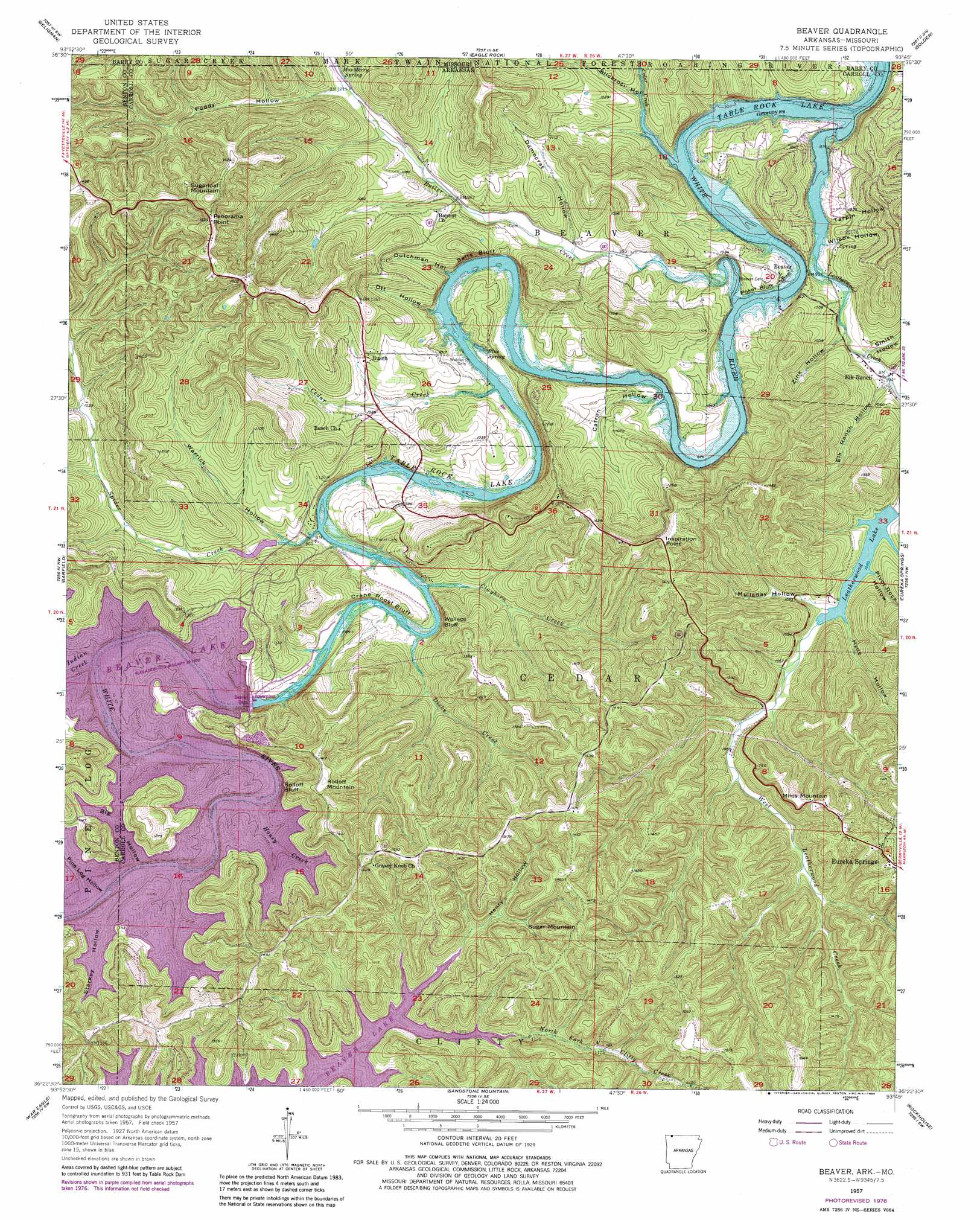
USGS Topo Quad 36093d7 - 1:24,000 scale
| Topo Map Name: | Beaver |
| USGS Topo Quad ID: | 36093d7 |
| Print Size: | ca. 21 1/4" wide x 27" high |
| Southeast Coordinates: | 36.375° N latitude / 93.75° W longitude |
| Map Center Coordinates: | 36.4375° N latitude / 93.8125° W longitude |
| U.S. States: | AR, MO |
| Filename: | o36093d7.jpg |
| Download Map JPG Image: | Beaver topo map 1:24,000 scale |
| Map Type: | Topographic |
| Topo Series: | 7.5´ |
| Map Scale: | 1:24,000 |
| Source of Map Images: | United States Geological Survey (USGS) |
| Alternate Map Versions: |
Beaver AR 1957, updated 1959 Download PDF Buy paper map Beaver AR 1957, updated 1965 Download PDF Buy paper map Beaver AR 1957, updated 1977 Download PDF Buy paper map Beaver AR 1957, updated 1984 Download PDF Buy paper map Beaver AR 2012 Download PDF Buy paper map Beaver AR 2014 Download PDF Buy paper map |
| FStopo: | US Forest Service topo Beaver is available: Download FStopo PDF Download FStopo TIF |
1:24,000 Topo Quads surrounding Beaver
Rocky Comfort |
Exeter |
Cassville |
Shell Knob |
Cape Fair |
Jacket |
Seligman |
Eagle Rock |
Golden |
Viola |
Pea Ridge |
Garfield |
Beaver |
Eureka Springs |
Grandview |
Rogers |
War Eagle |
Sandstone Mountain |
Rockhouse |
Berryville |
Sonora |
Spring Valley |
Hindsville |
Forum |
Marble |
> Back to 36093a1 at 1:100,000 scale
> Back to 36092a1 at 1:250,000 scale
> Back to U.S. Topo Maps home
Beaver topo map: Gazetteer
Beaver: Bridges
Beaver Bridge elevation 270m 885′Mulladay Hollow Bridge elevation 316m 1036′
Beaver: Cliffs
Crane Roost Bluff elevation 314m 1030′Inspiration Point elevation 427m 1400′
Poker Bluff elevation 300m 984′
Rolloff Bluff elevation 393m 1289′
Salts Bluff elevation 351m 1151′
Wallace Bluff elevation 342m 1122′
Beaver: Crossings
Huffman Ford (historical) elevation 342m 1122′Beaver: Dams
Beaver Dam elevation 333m 1092′Farwell Spider Creek Lake Dam elevation 284m 931′
Lake Leatherwood Dam elevation 310m 1017′
Beaver: Parks
Beaver Dam Site Park elevation 312m 1023′Beaver: Populated Places
Beaver elevation 277m 908′Busch elevation 335m 1099′
Walden (historical) elevation 294m 964′
Beaver: Post Offices
Busch Post Office elevation 328m 1076′Beaver: Reservoirs
Beaver Lake elevation 333m 1092′Farwell Spider Creek Lake elevation 284m 931′
Lake Leatherwood elevation 310m 1017′
Beaver: Springs
Blue Spring elevation 277m 908′MacMerry Spring elevation 309m 1013′
Beaver: Streams
Butler Creek elevation 270m 885′Butler Creek elevation 279m 915′
Cedar Creek elevation 272m 892′
Cedar Creek elevation 272m 892′
Cedar Creek elevation 279m 915′
Clayborn Creek elevation 277m 908′
Dicks Creek elevation 276m 905′
Honey Creek elevation 338m 1108′
Indian Creek elevation 342m 1122′
Leatherwood Creek elevation 277m 908′
North Fork North Clifty Creek elevation 334m 1095′
Spider Creek elevation 275m 902′
Beaver: Summits
Miles Mountain elevation 432m 1417′Panorama Point elevation 478m 1568′
Rolloff Mountain elevation 436m 1430′
Sugar Mountain elevation 470m 1541′
Sugarloaf Mountain elevation 503m 1650′
Beaver: Valleys
Big Hollow elevation 335m 1099′Catron Hollow elevation 274m 898′
Democrat Hollow elevation 291m 954′
Dutchman Hollow elevation 272m 892′
Elk Ranch Hollow elevation 289m 948′
Henry Hollow elevation 344m 1128′
Hyde Hollow elevation 365m 1197′
Mulladay Hollow elevation 308m 1010′
Ott Hollow elevation 299m 980′
Pine Log Hollow elevation 342m 1122′
Pivot Rock Hollow elevation 315m 1033′
Poddy Hollow elevation 317m 1040′
Slickrock Hollow elevation 286m 938′
Smith Hollow elevation 298m 977′
Starkey Hollow elevation 342m 1122′
Tarpin Hollow elevation 296m 971′
Warrick Hollow elevation 280m 918′
Wilcox Hollow elevation 289m 948′
Zink Hollow elevation 285m 935′
Beaver digital topo map on disk
Buy this Beaver topo map showing relief, roads, GPS coordinates and other geographical features, as a high-resolution digital map file on DVD: