Bentonville South Topo Map Arkansas
To zoom in, hover over the map of Bentonville South
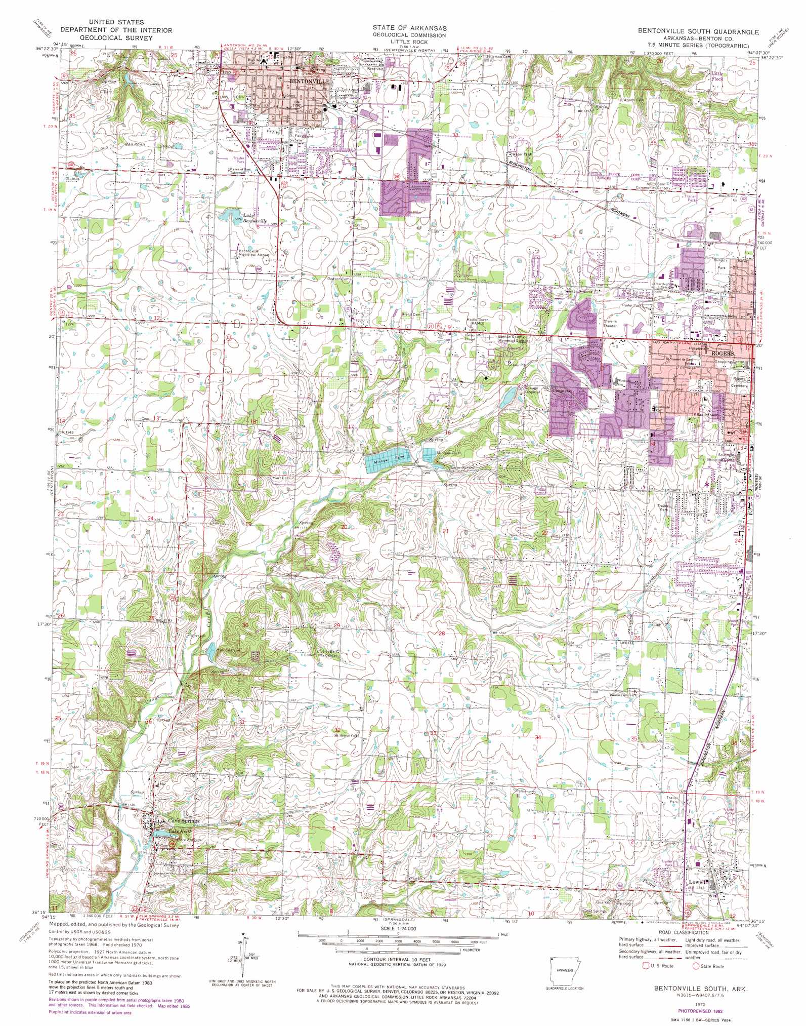
USGS Topo Quad 36094c2 - 1:24,000 scale
| Topo Map Name: | Bentonville South |
| USGS Topo Quad ID: | 36094c2 |
| Print Size: | ca. 21 1/4" wide x 27" high |
| Southeast Coordinates: | 36.25° N latitude / 94.125° W longitude |
| Map Center Coordinates: | 36.3125° N latitude / 94.1875° W longitude |
| U.S. State: | AR |
| Filename: | o36094c2.jpg |
| Download Map JPG Image: | Bentonville South topo map 1:24,000 scale |
| Map Type: | Topographic |
| Topo Series: | 7.5´ |
| Map Scale: | 1:24,000 |
| Source of Map Images: | United States Geological Survey (USGS) |
| Alternate Map Versions: |
Bentonville South AR 1970, updated 1972 Download PDF Buy paper map Bentonville South AR 1970, updated 1977 Download PDF Buy paper map Bentonville South AR 1970, updated 1982 Download PDF Buy paper map Bentonville South AR 2011 Download PDF Buy paper map Bentonville South AR 2014 Download PDF Buy paper map |
1:24,000 Topo Quads surrounding Bentonville South
Noel |
Jane |
Powell |
Jacket |
Seligman |
Gravette |
Hiwasse |
Bentonville North |
Pea Ridge |
Garfield |
Gentry |
Centerton |
Bentonville South |
Rogers |
War Eagle |
Gallatin |
Robinson |
Springdale |
Sonora |
Spring Valley |
Rhea |
Wheeler |
Fayettville |
Elkins |
Goshen |
> Back to 36094a1 at 1:100,000 scale
> Back to 36094a1 at 1:250,000 scale
> Back to U.S. Topo Maps home
Bentonville South topo map: Gazetteer
Bentonville South: Airports
Bentonville Municipal Airport elevation 395m 1295′Medi-Port Heliport elevation 410m 1345′
Bentonville South: Areas
Osage Prairie elevation 394m 1292′Bentonville South: Dams
Jackson Lake Dam elevation 368m 1207′Lake Bentonville Dam elevation 391m 1282′
Lake Keith Dam elevation 346m 1135′
Bentonville South: Parks
Benton County Fairgrounds elevation 393m 1289′Ford Park elevation 392m 1286′
Bentonville South: Populated Places
Apple Spur elevation 400m 1312′Bentonville elevation 395m 1295′
Cannon (historical) elevation 376m 1233′
Cave Springs elevation 352m 1154′
Colville (historical) elevation 371m 1217′
Freeman (historical) elevation 400m 1312′
Hart (historical) elevation 386m 1266′
Lowell elevation 409m 1341′
Woods (historical) elevation 394m 1292′
Bentonville South: Post Offices
Bentonville Post Office elevation 393m 1289′Lowell Post Office elevation 408m 1338′
Bentonville South: Reservoirs
Jackson Lake elevation 368m 1207′Lake Bentonville elevation 391m 1282′
Lake Keith elevation 346m 1135′
Bentonville South: Springs
Cave Springs elevation 363m 1190′Osage Spring elevation 371m 1217′
Park Springs elevation 394m 1292′
Woods Springs elevation 384m 1259′
Bentonville South digital topo map on disk
Buy this Bentonville South topo map showing relief, roads, GPS coordinates and other geographical features, as a high-resolution digital map file on DVD: