Seneca Topo Map Missouri
To zoom in, hover over the map of Seneca
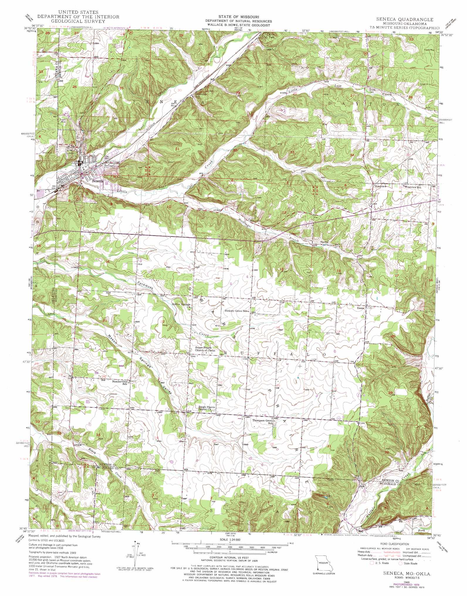
USGS Topo Quad 36094g5 - 1:24,000 scale
| Topo Map Name: | Seneca |
| USGS Topo Quad ID: | 36094g5 |
| Print Size: | ca. 21 1/4" wide x 27" high |
| Southeast Coordinates: | 36.75° N latitude / 94.5° W longitude |
| Map Center Coordinates: | 36.8125° N latitude / 94.5625° W longitude |
| U.S. States: | MO, OK |
| Filename: | o36094g5.jpg |
| Download Map JPG Image: | Seneca topo map 1:24,000 scale |
| Map Type: | Topographic |
| Topo Series: | 7.5´ |
| Map Scale: | 1:24,000 |
| Source of Map Images: | United States Geological Survey (USGS) |
| Alternate Map Versions: |
Seneca MO 1949, updated 1970 Download PDF Buy paper map Seneca MO 1949, updated 1979 Download PDF Buy paper map Seneca MO 1950 Download PDF Buy paper map Seneca MO 1950 Download PDF Buy paper map Seneca MO 2010 Download PDF Buy paper map Seneca MO 2012 Download PDF Buy paper map Seneca MO 2015 Download PDF Buy paper map |
1:24,000 Topo Quads surrounding Seneca
Neutral |
Baxter Springs |
Joplin West |
Joplin East |
Fidelity |
Picher |
Peoria |
Racine |
Tipton Ford |
Granby |
Miami Se |
Wyandotte |
Seneca |
Neosho West |
Neosho East |
Afton Ne |
Cayuga |
Tiff City |
Anderson |
Mcnatt |
Grove |
Dodge |
South West City |
Noel |
Jane |
> Back to 36094e1 at 1:100,000 scale
> Back to 36094a1 at 1:250,000 scale
> Back to U.S. Topo Maps home
Seneca topo map: Gazetteer
Seneca: Areas
Swars Prairie elevation 327m 1072′Seneca: Dams
Lost Creek Watershed Structure D-1 Dam elevation 324m 1062′Newton County Structure F-1 Dam elevation 312m 1023′
Newton County Structure F-2 Dam elevation 296m 971′
Newton County Structure F-3 Dam elevation 282m 925′
Seneca: Populated Places
Dessa elevation 346m 1135′May elevation 276m 905′
Seneca elevation 258m 846′
Wela Park elevation 280m 918′
West Seneca elevation 257m 843′
Westview elevation 347m 1138′
Seneca: Reservoirs
Structure F-1 Reservoir elevation 312m 1023′Structure F-2 Reservoir elevation 296m 971′
Structure F-3 Reservoir elevation 282m 925′
Seneca: Streams
Little Lost Creek elevation 256m 839′MacDougal Branch elevation 269m 882′
Seneca: Valleys
Charleton Hollow elevation 283m 928′Seneca digital topo map on disk
Buy this Seneca topo map showing relief, roads, GPS coordinates and other geographical features, as a high-resolution digital map file on DVD: