Miami Se Topo Map Oklahoma
To zoom in, hover over the map of Miami Se
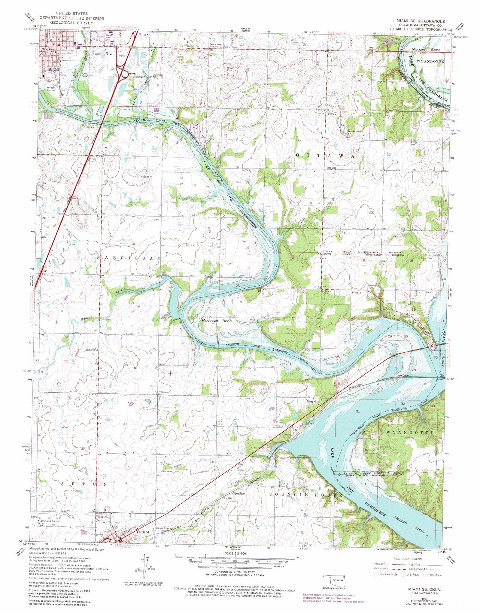
USGS Topo Quad 36094g7 - 1:24,000 scale
| Topo Map Name: | Miami Se |
| USGS Topo Quad ID: | 36094g7 |
| Print Size: | ca. 21 1/4" wide x 27" high |
| Southeast Coordinates: | 36.75° N latitude / 94.75° W longitude |
| Map Center Coordinates: | 36.8125° N latitude / 94.8125° W longitude |
| U.S. State: | OK |
| Filename: | o36094g7.jpg |
| Download Map JPG Image: | Miami Se topo map 1:24,000 scale |
| Map Type: | Topographic |
| Topo Series: | 7.5´ |
| Map Scale: | 1:24,000 |
| Source of Map Images: | United States Geological Survey (USGS) |
| Alternate Map Versions: |
Miami SE OK 1961, updated 1963 Download PDF Buy paper map Miami SE OK 1961, updated 1979 Download PDF Buy paper map Miami SE OK 1961, updated 1982 Download PDF Buy paper map Miami SE OK 2010 Download PDF Buy paper map Miami SE OK 2012 Download PDF Buy paper map Miami SE OK 2016 Download PDF Buy paper map |
1:24,000 Topo Quads surrounding Miami Se
Chetopa |
Melrose |
Neutral |
Baxter Springs |
Joplin West |
Welch North |
Miami Nw |
Picher |
Peoria |
Racine |
Welch South |
Miami Sw |
Miami Se |
Wyandotte |
Seneca |
Vinita Ne |
Afton |
Afton Ne |
Cayuga |
Tiff City |
Ketchum |
Bernice |
Grove |
Dodge |
South West City |
> Back to 36094e1 at 1:100,000 scale
> Back to 36094a1 at 1:250,000 scale
> Back to U.S. Topo Maps home
Miami Se topo map: Gazetteer
Miami Se: Bends
Moccasin Bend elevation 235m 770′Mudeater Bend elevation 230m 754′
Miami Se: Crossings
Miami Interchange elevation 238m 780′Miami Se: Parks
Riverview Park elevation 231m 757′Taylor Park elevation 233m 764′
Twin Bridges State Park elevation 246m 807′
Miami Se: Populated Places
Fairland elevation 254m 833′Moreville elevation 242m 793′
Ogeechee elevation 238m 780′
Ottawa elevation 276m 905′
Miami Se: Streams
Hudson Creek elevation 226m 741′Little Elm Creek elevation 226m 741′
Ogeechee Creek elevation 225m 738′
Spring River elevation 225m 738′
Tar Creek elevation 226m 741′
Miami Se digital topo map on disk
Buy this Miami Se topo map showing relief, roads, GPS coordinates and other geographical features, as a high-resolution digital map file on DVD: