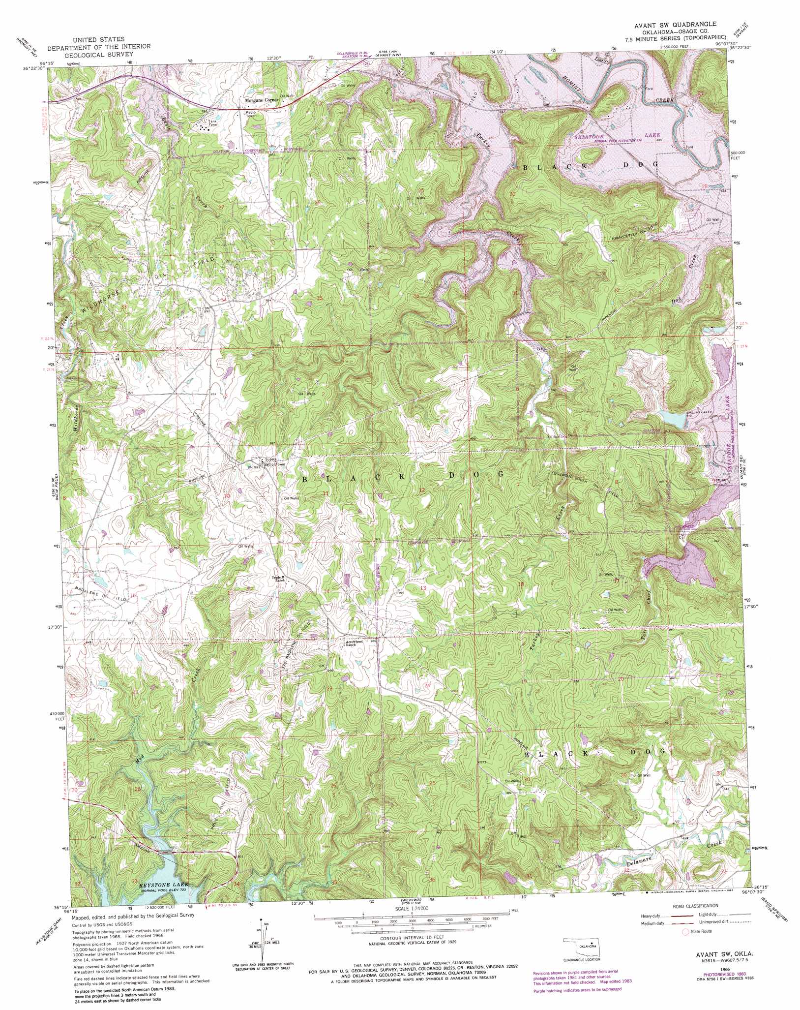
Avant Sw Topo Map Oklahoma
To zoom in, hover over the map of Avant Sw
USGS Topo Quad 36096c2 - 1:24,000 scale
| Topo Map Name: | Avant Sw |
| USGS Topo Quad ID: | 36096c2 |
| Print Size: | ca. 21 1/4" wide x 27" high |
| Southeast Coordinates: | 36.25° N latitude / 96.125° W longitude |
| Map Center Coordinates: | 36.3125° N latitude / 96.1875° W longitude |
| U.S. State: | OK |
| Filename: | o36096c2.jpg |
| Download Map JPG Image: | Avant Sw topo map 1:24,000 scale |
| Map Type: | Topographic |
| Topo Series: | 7.5´ |
| Map Scale: | 1:24,000 |
| Source of Map Images: | United States Geological Survey (USGS) |
| Alternate Map Versions: |
Avant SW OK 1966, updated 1967 Download PDF Buy paper map Avant SW OK 1966, updated 1976 Download PDF Buy paper map Avant SW OK 1966, updated 1983 Download PDF Buy paper map Avant SW OK 2010 Download PDF Buy paper map Avant SW OK 2013 Download PDF Buy paper map Avant SW OK 2016 Download PDF Buy paper map |
1:24,000 Topo Quads surrounding Avant Sw
Happy Hollow |
Wynona |
Barnsdall |
Wolco |
Ramona |
Hominy |
Hominy Ne |
Avant Nw |
Avant |
Vera |
Cleveland |
New Prue |
Avant Sw |
Avant Se |
Sperry |
Terlton |
Keystone Dam |
Wekiwa |
Sand Springs |
Tulsa |
Olive |
Mannford Se |
Lake Sahoma |
Sapulpa North |
Jenks |
> Back to 36096a1 at 1:100,000 scale
> Back to 36096a1 at 1:250,000 scale
> Back to U.S. Topo Maps home
Avant Sw topo map: Gazetteer
Avant Sw: Dams
Oknoname 113002 Dam elevation 222m 728′Oknoname 113003 Dam elevation 219m 718′
Oknoname 113004 Dam elevation 218m 715′
Oknoname 113066 Dam elevation 259m 849′
Oknoname 113067 Dam elevation 218m 715′
Avant Sw: Oilfields
Branstetter Oil Field elevation 240m 787′East Madalene Oil Field elevation 269m 882′
Edgewood South Oil Field elevation 264m 866′
Madalene Oil Field elevation 266m 872′
Prue Oil Field elevation 260m 853′
Wildhorse Oil Field elevation 260m 853′
Avant Sw: Populated Places
Morgans Corner elevation 247m 810′Avant Sw: Reservoirs
Oknoname 113002 Reservoir elevation 222m 728′Oknoname 113003 Reservoir elevation 219m 718′
Oknoname 113004 Reservoir elevation 218m 715′
Oknoname 113066 Reservoir elevation 259m 849′
Oknoname 113067 Reservoir elevation 218m 715′
Avant Sw: Streams
Lost Creek elevation 218m 715′Avant Sw digital topo map on disk
Buy this Avant Sw topo map showing relief, roads, GPS coordinates and other geographical features, as a high-resolution digital map file on DVD: