Cleveland Topo Map Oklahoma
To zoom in, hover over the map of Cleveland
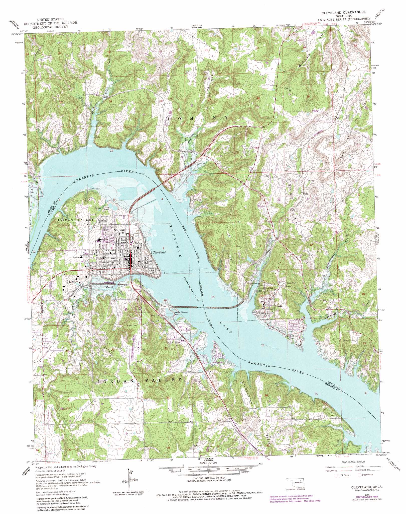
USGS Topo Quad 36096c4 - 1:24,000 scale
| Topo Map Name: | Cleveland |
| USGS Topo Quad ID: | 36096c4 |
| Print Size: | ca. 21 1/4" wide x 27" high |
| Southeast Coordinates: | 36.25° N latitude / 96.375° W longitude |
| Map Center Coordinates: | 36.3125° N latitude / 96.4375° W longitude |
| U.S. State: | OK |
| Filename: | o36096c4.jpg |
| Download Map JPG Image: | Cleveland topo map 1:24,000 scale |
| Map Type: | Topographic |
| Topo Series: | 7.5´ |
| Map Scale: | 1:24,000 |
| Source of Map Images: | United States Geological Survey (USGS) |
| Alternate Map Versions: |
Cleveland OK 1966, updated 1967 Download PDF Buy paper map Cleveland OK 1966, updated 1983 Download PDF Buy paper map Cleveland OK 2009 Download PDF Buy paper map Cleveland OK 2012 Download PDF Buy paper map Cleveland OK 2016 Download PDF Buy paper map |
1:24,000 Topo Quads surrounding Cleveland
Fairfax |
Lucy Creek |
Happy Hollow |
Wynona |
Barnsdall |
Skedee |
Bug Creek |
Hominy |
Hominy Ne |
Avant Nw |
Casey |
Blackburn |
Cleveland |
New Prue |
Avant Sw |
Maramec |
Jennings |
Terlton |
Keystone Dam |
Wekiwa |
Yale |
Oilton |
Olive |
Mannford Se |
Lake Sahoma |
> Back to 36096a1 at 1:100,000 scale
> Back to 36096a1 at 1:250,000 scale
> Back to U.S. Topo Maps home
Cleveland topo map: Gazetteer
Cleveland: Airports
Cleveland Municipal Airport elevation 292m 958′Cleveland: Dams
Oknoname 113100 Dam elevation 232m 761′Oknoname 113101 Dam elevation 291m 954′
Cleveland: Oilfields
Boar Creek Oil Field elevation 298m 977′Boston Oil Field elevation 223m 731′
Cleveland Oil Field elevation 249m 816′
Lauderdale Oil Field elevation 298m 977′
Lauderdale Oil Field elevation 264m 866′
Osage City Oil Field elevation 283m 928′
Cleveland: Parks
Feyodi Creek State Park elevation 225m 738′Osage Point Park elevation 227m 744′
Cleveland: Populated Places
Cleveland elevation 237m 777′Osage elevation 247m 810′
Cleveland: Reservoirs
Oknoname 113100 Reservoir elevation 232m 761′Oknoname 113101 Reservoir elevation 291m 954′
Cleveland: Streams
Black Dog Creek elevation 220m 721′Cedar Creek elevation 220m 721′
Mechetsemoi Creek elevation 220m 721′
Mill Creek elevation 220m 721′
Sand Creek elevation 223m 731′
Scanlon Creek elevation 220m 721′
Vandruff Creek elevation 220m 721′
Cleveland digital topo map on disk
Buy this Cleveland topo map showing relief, roads, GPS coordinates and other geographical features, as a high-resolution digital map file on DVD: