Pawnee Topo Map Oklahoma
To zoom in, hover over the map of Pawnee
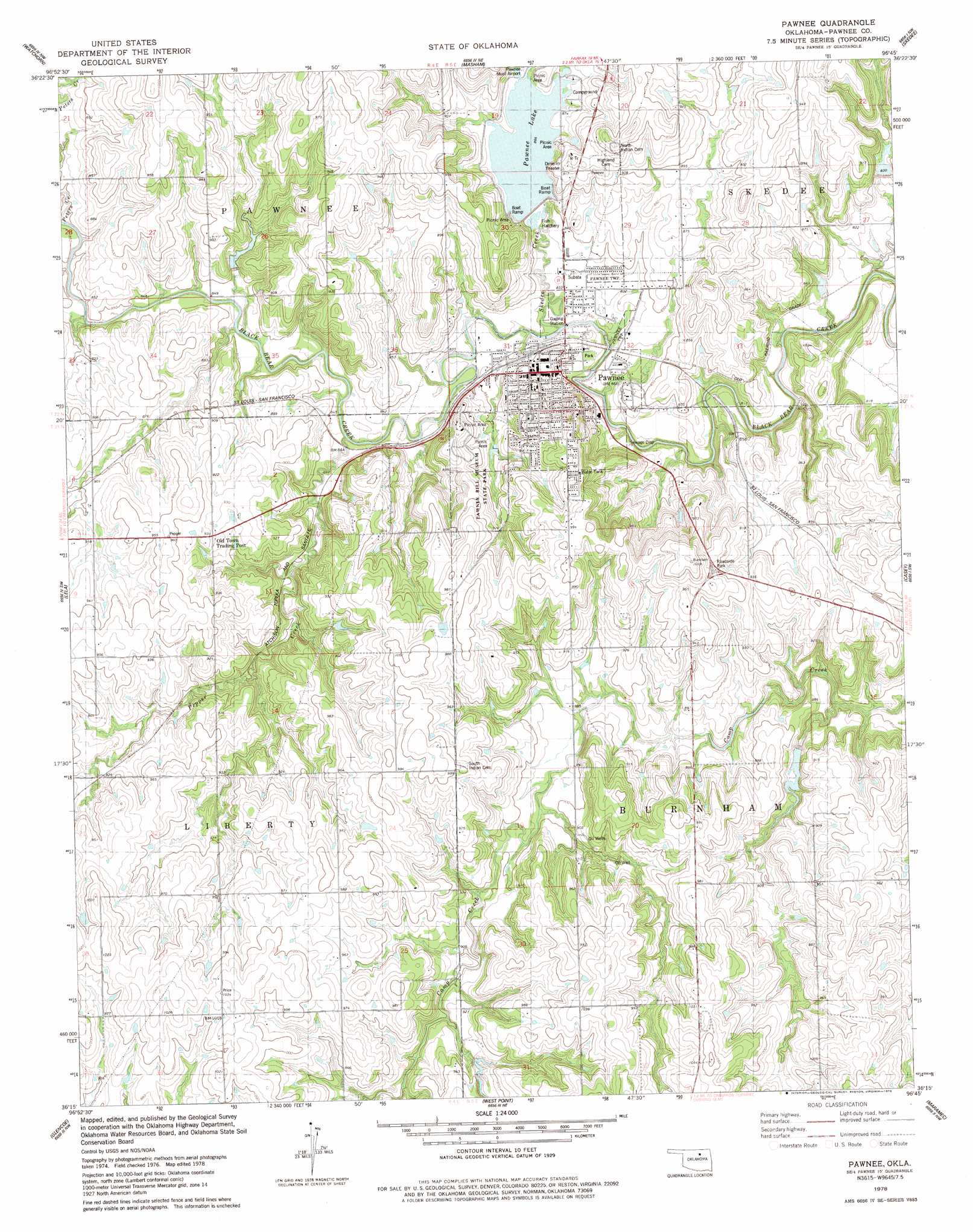
USGS Topo Quad 36096c7 - 1:24,000 scale
| Topo Map Name: | Pawnee |
| USGS Topo Quad ID: | 36096c7 |
| Print Size: | ca. 21 1/4" wide x 27" high |
| Southeast Coordinates: | 36.25° N latitude / 96.75° W longitude |
| Map Center Coordinates: | 36.3125° N latitude / 96.8125° W longitude |
| U.S. State: | OK |
| Filename: | o36096c7.jpg |
| Download Map JPG Image: | Pawnee topo map 1:24,000 scale |
| Map Type: | Topographic |
| Topo Series: | 7.5´ |
| Map Scale: | 1:24,000 |
| Source of Map Images: | United States Geological Survey (USGS) |
| Alternate Map Versions: |
Pawnee OK 1978, updated 1978 Download PDF Buy paper map Pawnee OK 2009 Download PDF Buy paper map Pawnee OK 2013 Download PDF Buy paper map Pawnee OK 2016 Download PDF Buy paper map |
1:24,000 Topo Quads surrounding Pawnee
Ponca City Se |
Prettyhair Creek |
Doga Creek |
Fairfax |
Lucy Creek |
Morrison Ne |
Watchorn |
Masham |
Skedee |
Bug Creek |
Morrison |
Lela |
Pawnee |
Casey |
Blackburn |
Stillwater North |
Glencoe |
West Point |
Maramec |
Jennings |
Stillwater South |
Ripley |
Twin Mounds |
Yale |
Oilton |
> Back to 36096a1 at 1:100,000 scale
> Back to 36096a1 at 1:250,000 scale
> Back to U.S. Topo Maps home
Pawnee topo map: Gazetteer
Pawnee: Airports
Pawnee Municipal Hospital Heliport elevation 277m 908′Pawnee: Dams
Lower Black Bear Creek Site 1 Dam elevation 254m 833′Lower Black Bear Creek Site 16 Dam elevation 264m 866′
Lower Black Bear Creek Site 18 Dam elevation 285m 935′
Lower Black Bear Creek Site 21 Dam elevation 284m 931′
Lower Black Bear Creek Site 23 Dam elevation 269m 882′
Lower Black Bear Creek Site 5 Dam elevation 259m 849′
Lower Black Bear Number 17 Dam elevation 267m 875′
Pawnee City Dam elevation 257m 843′
Pawnee: Parks
Pawnee Bill Museum State Park elevation 277m 908′Pawnee: Populated Places
Pawnee elevation 265m 869′Pawnee: Reservoirs
Lower Black Bear Creek Site 1 Reservoir elevation 254m 833′Lower Black Bear Creek Site 16 Reservoir elevation 264m 866′
Lower Black Bear Creek Site 18 Reservoir elevation 285m 935′
Lower Black Bear Creek Site 21 Reservoir elevation 284m 931′
Lower Black Bear Creek Site 23 Reservoir elevation 269m 882′
Lower Black Bear Creek Site 5 Reservoir elevation 259m 849′
Lower Black Bear Number 17 Reservoir elevation 267m 875′
Pawnee City Lake elevation 257m 843′
Pawnee Lake elevation 264m 866′
Pawnee: Streams
Little Skedee Creek elevation 264m 866′Pepper Creek elevation 250m 820′
Peters Creek elevation 253m 830′
Skedee Creek elevation 245m 803′
Pawnee digital topo map on disk
Buy this Pawnee topo map showing relief, roads, GPS coordinates and other geographical features, as a high-resolution digital map file on DVD: