Bowring Se Topo Map Oklahoma
To zoom in, hover over the map of Bowring Se
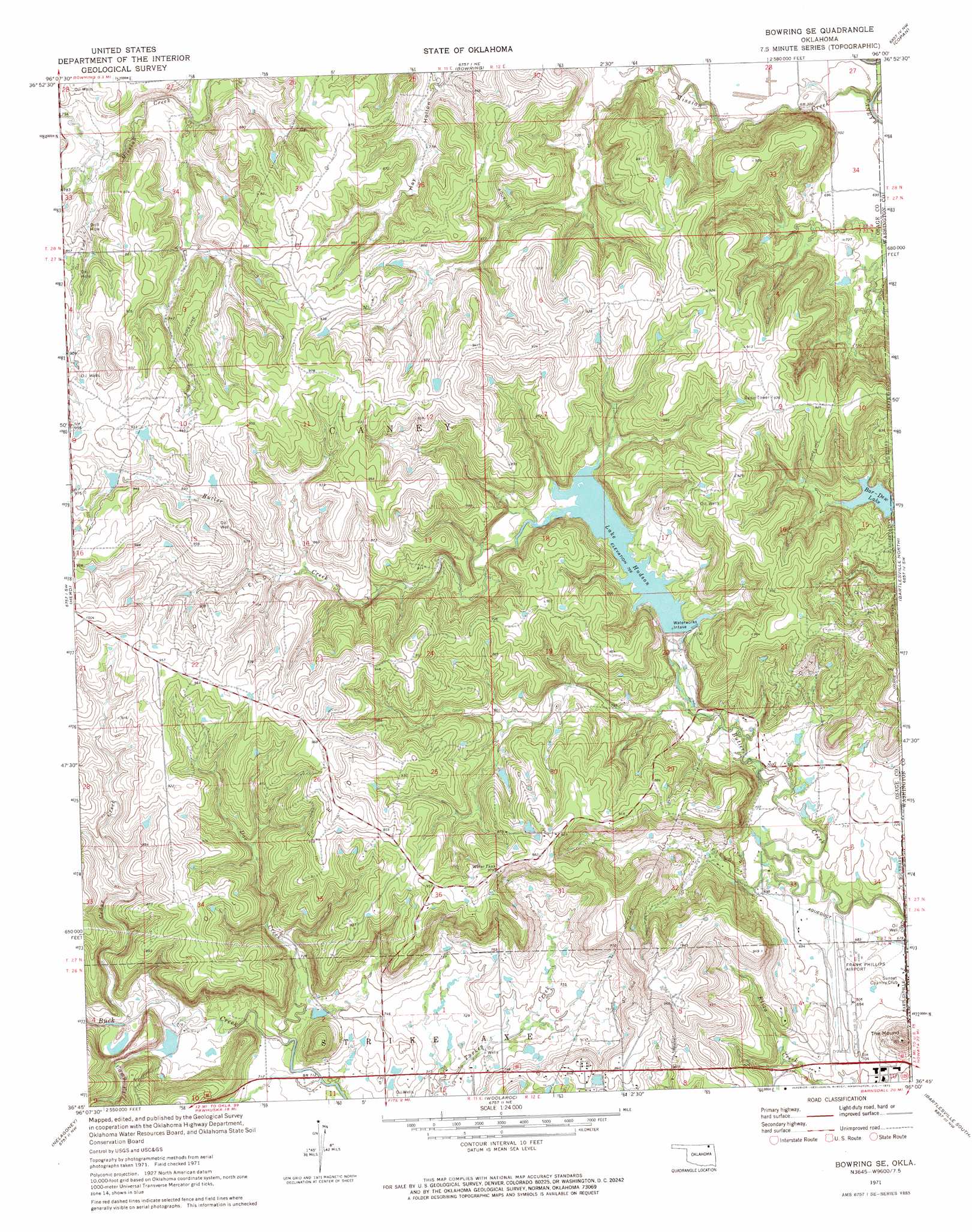
USGS Topo Quad 36096g1 - 1:24,000 scale
| Topo Map Name: | Bowring Se |
| USGS Topo Quad ID: | 36096g1 |
| Print Size: | ca. 21 1/4" wide x 27" high |
| Southeast Coordinates: | 36.75° N latitude / 96° W longitude |
| Map Center Coordinates: | 36.8125° N latitude / 96.0625° W longitude |
| U.S. State: | OK |
| Filename: | o36096g1.jpg |
| Download Map JPG Image: | Bowring Se topo map 1:24,000 scale |
| Map Type: | Topographic |
| Topo Series: | 7.5´ |
| Map Scale: | 1:24,000 |
| Source of Map Images: | United States Geological Survey (USGS) |
| Alternate Map Versions: |
Bowring SE OK 1971, updated 1973 Download PDF Buy paper map Bowring SE OK 2010 Download PDF Buy paper map Bowring SE OK 2012 Download PDF Buy paper map Bowring SE OK 2016 Download PDF Buy paper map |
1:24,000 Topo Quads surrounding Bowring Se
Elgin |
Chautauqua |
Peru |
Caney |
Tyro |
Pearsonia Ne |
Whippoorwill |
Bowring |
Copan |
Wann |
Nanos |
Herd |
Bowring Se |
Bartlesville North |
Blue Mound |
Pawhuska |
Nelagoney |
Woolaroc |
Bartlesville South |
Oglesby |
Wynona |
Barnsdall |
Wolco |
Ramona |
Bartlesville Se |
> Back to 36096e1 at 1:100,000 scale
> Back to 36096a1 at 1:250,000 scale
> Back to U.S. Topo Maps home
Bowring Se topo map: Gazetteer
Bowring Se: Airports
Bartlesville Municipal Airport elevation 211m 692′Frank Phillips Field elevation 211m 692′
Bowring Se: Dams
Bar-Dew Dam elevation 224m 734′Cotton-Coon-Mission Creek Site 1 Dam elevation 219m 718′
Hudson Dam elevation 231m 757′
Oknoname 113019 Dam elevation 251m 823′
Oknoname 113020 Dam elevation 255m 836′
Oknoname 113021 Dam elevation 265m 869′
Oknoname 113022 Dam elevation 284m 931′
Oknoname 113023 Dam elevation 256m 839′
Oknoname 113024 Dam elevation 243m 797′
Oknoname 113025 Dam elevation 221m 725′
Oknoname 113036 Dam elevation 269m 882′
Oknoname 113037 Dam elevation 278m 912′
Oknoname 113037 Dam elevation 281m 921′
Oknoname 113038 Dam elevation 292m 958′
Oknoname 113039 Dam elevation 265m 869′
Oknoname 113040 Dam elevation 282m 925′
Oknoname 113041 Dam elevation 290m 951′
Oknoname 113042 Dam elevation 263m 862′
Oknoname 113043 Dam elevation 279m 915′
Oknoname 113044 Dam elevation 279m 915′
Oknoname 113045 Dam elevation 280m 918′
Oknoname 113046 Dam elevation 280m 918′
Oknoname 113047 Dam elevation 214m 702′
Oknoname 113048 Dam elevation 217m 711′
Oknoname 113049 Dam elevation 224m 734′
Oknoname 113074 Dam elevation 259m 849′
Oknoname 113075 Dam elevation 237m 777′
Oknoname 113076 Dam elevation 230m 754′
Bowring Se: Reservoirs
Bar-Dew Lake elevation 224m 734′Bar-Dew Lake elevation 224m 734′
Cotton-Coon-Mission Creek Site 1 Reservoir elevation 219m 718′
Lake Hudson elevation 234m 767′
Oknoname 113019 Reservoir elevation 251m 823′
Oknoname 113020 Reservoir elevation 255m 836′
Oknoname 113021 Reservoir elevation 265m 869′
Oknoname 113022 Reservoir elevation 284m 931′
Oknoname 113023 Reservoir elevation 256m 839′
Oknoname 113024 Reservoir elevation 243m 797′
Oknoname 113025 Reservoir elevation 221m 725′
Oknoname 113036 Reservoir elevation 269m 882′
Oknoname 113037 Reservoir elevation 278m 912′
Oknoname 113037 Reservoir elevation 281m 921′
Oknoname 113038 Reservoir elevation 292m 958′
Oknoname 113039 Reservoir elevation 265m 869′
Oknoname 113040 Reservoir elevation 282m 925′
Oknoname 113041 Reservoir elevation 290m 951′
Oknoname 113042 Reservoir elevation 263m 862′
Oknoname 113043 Reservoir elevation 279m 915′
Oknoname 113044 Reservoir elevation 279m 915′
Oknoname 113045 Reservoir elevation 280m 918′
Oknoname 113046 Reservoir elevation 280m 918′
Oknoname 113047 Reservoir elevation 214m 702′
Oknoname 113048 Reservoir elevation 217m 711′
Oknoname 113049 Reservoir elevation 224m 734′
Oknoname 113074 Reservoir elevation 259m 849′
Oknoname 113075 Reservoir elevation 237m 777′
Oknoname 113076 Reservoir elevation 230m 754′
Bowring Se: Streams
Camp Creek elevation 216m 708′Cedar Creek elevation 216m 708′
Mission Creek elevation 206m 675′
Bowring Se: Summits
The Mound elevation 264m 866′Bowring Se digital topo map on disk
Buy this Bowring Se topo map showing relief, roads, GPS coordinates and other geographical features, as a high-resolution digital map file on DVD: