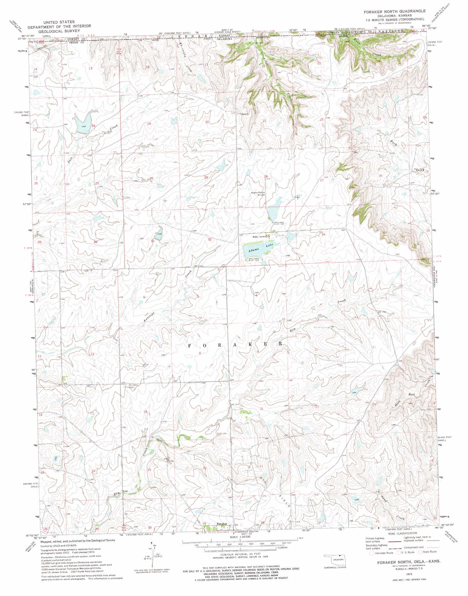
Foraker North Topo Map Oklahoma
To zoom in, hover over the map of Foraker North
USGS Topo Quad 36096h5 - 1:24,000 scale
| Topo Map Name: | Foraker North |
| USGS Topo Quad ID: | 36096h5 |
| Print Size: | ca. 21 1/4" wide x 27" high |
| Southeast Coordinates: | 36.875° N latitude / 96.5° W longitude |
| Map Center Coordinates: | 36.9375° N latitude / 96.5625° W longitude |
| U.S. States: | OK, KS |
| Filename: | o36096h5.jpg |
| Download Map JPG Image: | Foraker North topo map 1:24,000 scale |
| Map Type: | Topographic |
| Topo Series: | 7.5´ |
| Map Scale: | 1:24,000 |
| Source of Map Images: | United States Geological Survey (USGS) |
| Alternate Map Versions: |
Foraker North OK 1973, updated 1975 Download PDF Buy paper map Foraker North OK 2010 Download PDF Buy paper map Foraker North OK 2012 Download PDF Buy paper map Foraker North OK 2016 Download PDF Buy paper map |
1:24,000 Topo Quads surrounding Foraker North
Eaton |
Dexter |
Dexter Ne |
Cloverdale |
Elgin Ne |
Maple City |
Dexter Sw |
Cedar Vale West |
Cedar Vale East |
Elgin |
Hardy |
Grainola |
Foraker North |
Pearsonia Nw |
Pearsonia Ne |
Kaw City |
Shidler |
Foraker South |
Pearsonia |
Nanos |
Charley Creek West |
Burbank |
Baconrind Creek |
Bluestem Lake |
Pawhuska |
> Back to 36096e1 at 1:100,000 scale
> Back to 36096a1 at 1:250,000 scale
> Back to U.S. Topo Maps home
Foraker North topo map: Gazetteer
Foraker North: Airports
Adams Ranch Airport elevation 398m 1305′Foraker North: Dams
Adams Lake Dam elevation 389m 1276′Adams Ranch Airport Lake Dam elevation 395m 1295′
Big Caney Creek Site 11 Dam elevation 347m 1138′
Oknoname 113052 Dam elevation 387m 1269′
Oknoname 113053 Dam elevation 381m 1250′
Oknoname 113127 Dam elevation 398m 1305′
Oknoname 113130 Dam elevation 389m 1276′
Oknoname 113131 Dam elevation 396m 1299′
Oknoname 113132 Dam elevation 391m 1282′
Oknoname 113133 Dam elevation 358m 1174′
Oknoname 113134 Dam elevation 371m 1217′
Oknoname 113135 Dam elevation 376m 1233′
Oknoname 113136 Dam elevation 363m 1190′
Oknoname 113137 Dam elevation 380m 1246′
Oknoname 113138 Dam elevation 381m 1250′
Foraker North: Reservoirs
Adams Lake elevation 388m 1272′Adams Ranch Airport Lake elevation 395m 1295′
Big Caney Creek Site 11 Reservoir elevation 347m 1138′
Oknoname 113052 Reservoir elevation 387m 1269′
Oknoname 113053 Reservoir elevation 381m 1250′
Oknoname 113127 Reservoir elevation 398m 1305′
Oknoname 113130 Reservoir elevation 389m 1276′
Oknoname 113131 Reservoir elevation 396m 1299′
Oknoname 113132 Reservoir elevation 391m 1282′
Oknoname 113133 Reservoir elevation 358m 1174′
Oknoname 113134 Reservoir elevation 371m 1217′
Oknoname 113135 Reservoir elevation 376m 1233′
Oknoname 113136 Reservoir elevation 363m 1190′
Oknoname 113137 Reservoir elevation 380m 1246′
Oknoname 113138 Reservoir elevation 381m 1250′
Foraker North digital topo map on disk
Buy this Foraker North topo map showing relief, roads, GPS coordinates and other geographical features, as a high-resolution digital map file on DVD: