Perry Nw Topo Map Oklahoma
To zoom in, hover over the map of Perry Nw
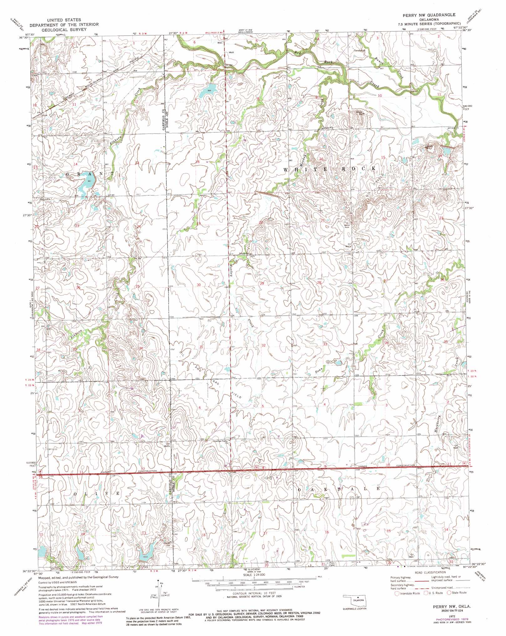
USGS Topo Quad 36097d4 - 1:24,000 scale
| Topo Map Name: | Perry Nw |
| USGS Topo Quad ID: | 36097d4 |
| Print Size: | ca. 21 1/4" wide x 27" high |
| Southeast Coordinates: | 36.375° N latitude / 97.375° W longitude |
| Map Center Coordinates: | 36.4375° N latitude / 97.4375° W longitude |
| U.S. State: | OK |
| Filename: | o36097d4.jpg |
| Download Map JPG Image: | Perry Nw topo map 1:24,000 scale |
| Map Type: | Topographic |
| Topo Series: | 7.5´ |
| Map Scale: | 1:24,000 |
| Source of Map Images: | United States Geological Survey (USGS) |
| Alternate Map Versions: |
Perry NW OK 1972, updated 1974 Download PDF Buy paper map Perry NW OK 1972, updated 1979 Download PDF Buy paper map Perry NW OK 1972, updated 1985 Download PDF Buy paper map Perry NW OK 2010 Download PDF Buy paper map Perry NW OK 2012 Download PDF Buy paper map Perry NW OK 2016 Download PDF Buy paper map |
1:24,000 Topo Quads surrounding Perry Nw
Lamont Nw |
Lamont |
Eddy |
Tonkawa |
Ponca City Nw |
Hunter |
Lamont Se |
Billings |
Tonkawa Se |
Marland |
Breckinridge |
Garber |
Perry Nw |
Ceres |
Red Rock |
Fairmont |
Covington |
Lucien |
Perry |
Black Bear |
Marshall West |
Marshall East |
Orlando West |
Orlando East |
Lake Carl Blackwell |
> Back to 36097a1 at 1:100,000 scale
> Back to 36096a1 at 1:250,000 scale
> Back to U.S. Topo Maps home
Perry Nw topo map: Gazetteer
Perry Nw: Dams
Upper Black Bear Creek Site 24 Dam elevation 316m 1036′Upper Black Bear Creek Site 25 Dam elevation 319m 1046′
Upper Black Bear Creek Site 26 Dam elevation 322m 1056′
Upper Red Rock Creek Site 39 Dam elevation 302m 990′
Upper Red Rock Creek Site 46 Dam elevation 304m 997′
Upper Red Rock Creek Site 48 Dam elevation 295m 967′
Upper Red Rock Creek Site 50 Dam elevation 302m 990′
Upper Red Rock Creek Site 51 Dam elevation 286m 938′
Upper Red Rock Creek Site 53 Dam elevation 298m 977′
Upper Red Rock Creek Site Number 47 Dam elevation 313m 1026′
Perry Nw: Reservoirs
Upper Black Bear Creek Site 24 Reservoir elevation 316m 1036′Upper Black Bear Creek Site 25 Reservoir elevation 319m 1046′
Upper Black Bear Creek Site 26 Reservoir elevation 322m 1056′
Upper Red Rock Creek Site 39 Reservoir elevation 302m 990′
Upper Red Rock Creek Site 46 Reservoir elevation 304m 997′
Upper Red Rock Creek Site 48 Reservoir elevation 295m 967′
Upper Red Rock Creek Site 50 Reservoir elevation 302m 990′
Upper Red Rock Creek Site 51 Reservoir elevation 286m 938′
Upper Red Rock Creek Site 53 Reservoir elevation 298m 977′
Upper Red Rock Creek Site Number 47 Reservoir elevation 313m 1026′
Perry Nw: Streams
Bunch Creek elevation 283m 928′Elkhorn Creek elevation 287m 941′
Monkey Creek elevation 287m 941′
Perry Nw digital topo map on disk
Buy this Perry Nw topo map showing relief, roads, GPS coordinates and other geographical features, as a high-resolution digital map file on DVD: