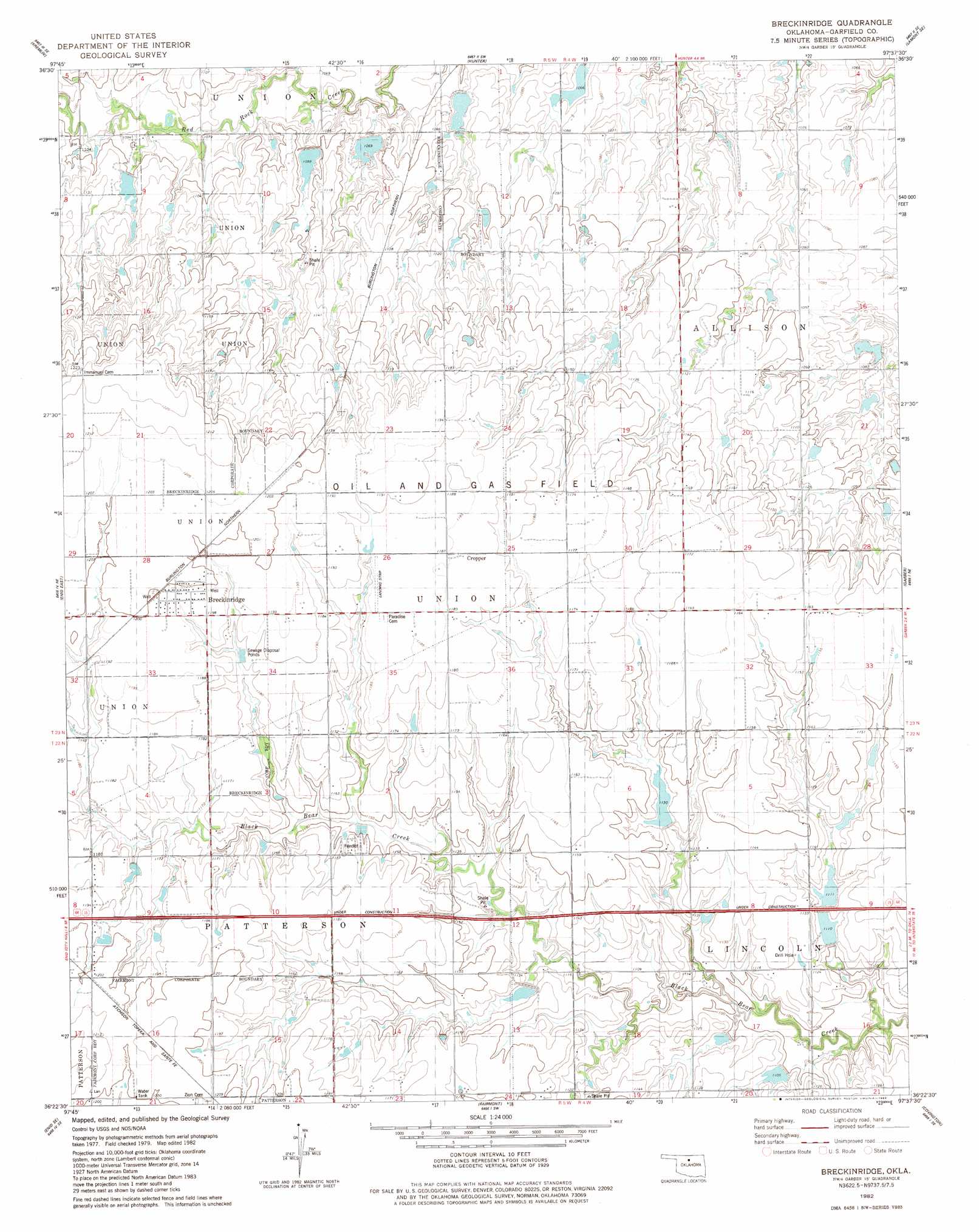
Breckinridge Topo Map Oklahoma
To zoom in, hover over the map of Breckinridge
USGS Topo Quad 36097d6 - 1:24,000 scale
| Topo Map Name: | Breckinridge |
| USGS Topo Quad ID: | 36097d6 |
| Print Size: | ca. 21 1/4" wide x 27" high |
| Southeast Coordinates: | 36.375° N latitude / 97.625° W longitude |
| Map Center Coordinates: | 36.4375° N latitude / 97.6875° W longitude |
| U.S. State: | OK |
| Filename: | o36097d6.jpg |
| Download Map JPG Image: | Breckinridge topo map 1:24,000 scale |
| Map Type: | Topographic |
| Topo Series: | 7.5´ |
| Map Scale: | 1:24,000 |
| Source of Map Images: | United States Geological Survey (USGS) |
| Alternate Map Versions: |
Breckinridge OK 1982, updated 1983 Download PDF Buy paper map Breckinridge OK 2010 Download PDF Buy paper map Breckinridge OK 2012 Download PDF Buy paper map Breckinridge OK 2016 Download PDF Buy paper map |
1:24,000 Topo Quads surrounding Breckinridge
Pond Creek Nw |
Pond Creek |
Lamont Nw |
Lamont |
Eddy |
Hillsdale |
Kremlin |
Hunter |
Lamont Se |
Billings |
Enid West |
Enid East |
Breckinridge |
Garber |
Perry Nw |
Waukomis |
Enid Se |
Fairmont |
Covington |
Lucien |
Bison |
Steinerts Lake |
Marshall West |
Marshall East |
Orlando West |
> Back to 36097a1 at 1:100,000 scale
> Back to 36096a1 at 1:250,000 scale
> Back to U.S. Topo Maps home
Breckinridge topo map: Gazetteer
Breckinridge: Dams
Upper Black Bear Creek Site 31 Dam elevation 341m 1118′Upper Black Bear Creek Site 32 Dam elevation 346m 1135′
Upper Black Bear Creek Site 34 Dam elevation 342m 1122′
Upper Black Bear Creek Site 37 Dam elevation 338m 1108′
Upper Black Bear Creek Site 38 Dam elevation 336m 1102′
Upper Red Rock Creek Site 30 Dam elevation 339m 1112′
Upper Red Rock Creek Site 31 Dam elevation 337m 1105′
Upper Red Rock Creek Site 32 Dam elevation 326m 1069′
Upper Red Rock Creek Site 33 Dam elevation 328m 1076′
Breckinridge: Populated Places
Breckinridge elevation 366m 1200′Cropper elevation 361m 1184′
Breckinridge: Reservoirs
Upper Black Bear Creek Site 31 Reservoir elevation 341m 1118′Upper Black Bear Creek Site 32 Reservoir elevation 346m 1135′
Upper Black Bear Creek Site 34 Reservoir elevation 342m 1122′
Upper Black Bear Creek Site 37 Reservoir elevation 338m 1108′
Upper Black Bear Creek Site 38 Reservoir elevation 336m 1102′
Upper Red Rock Creek Site 30 Reservoir elevation 339m 1112′
Upper Red Rock Creek Site 31 Reservoir elevation 337m 1105′
Upper Red Rock Creek Site 32 Reservoir elevation 326m 1069′
Upper Red Rock Creek Site 33 Reservoir elevation 328m 1076′
Breckinridge digital topo map on disk
Buy this Breckinridge topo map showing relief, roads, GPS coordinates and other geographical features, as a high-resolution digital map file on DVD: