Ponca City Topo Map Oklahoma
To zoom in, hover over the map of Ponca City
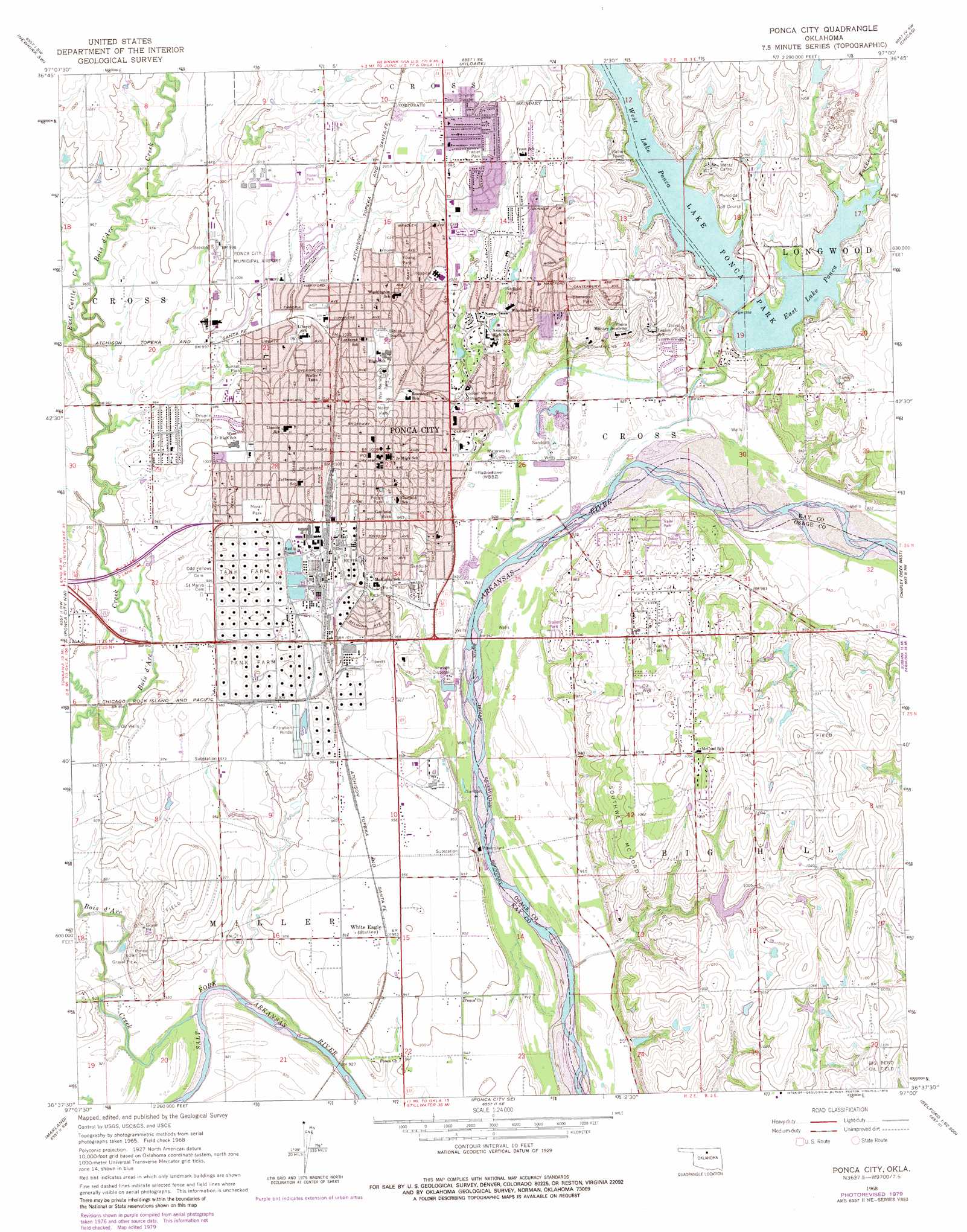
USGS Topo Quad 36097f1 - 1:24,000 scale
| Topo Map Name: | Ponca City |
| USGS Topo Quad ID: | 36097f1 |
| Print Size: | ca. 21 1/4" wide x 27" high |
| Southeast Coordinates: | 36.625° N latitude / 97° W longitude |
| Map Center Coordinates: | 36.6875° N latitude / 97.0625° W longitude |
| U.S. State: | OK |
| Filename: | o36097f1.jpg |
| Download Map JPG Image: | Ponca City topo map 1:24,000 scale |
| Map Type: | Topographic |
| Topo Series: | 7.5´ |
| Map Scale: | 1:24,000 |
| Source of Map Images: | United States Geological Survey (USGS) |
| Alternate Map Versions: |
Ponca City OK 1968, updated 1970 Download PDF Buy paper map Ponca City OK 1968, updated 1979 Download PDF Buy paper map Ponca City OK 2010 Download PDF Buy paper map Ponca City OK 2012 Download PDF Buy paper map Ponca City OK 2016 Download PDF Buy paper map |
1:24,000 Topo Quads surrounding Ponca City
Braman |
Peckham |
Newkirk |
Kaw City Nw |
Hardy |
Blackwell |
Newkirk Sw |
Kildare |
Uncas |
Kaw City |
Tonkawa |
Ponca City Nw |
Ponca City |
Charley Creek East |
Charley Creek West |
Tonkawa Se |
Marland |
Ponca City Se |
Prettyhair Creek |
Doga Creek |
Ceres |
Red Rock |
Morrison Ne |
Watchorn |
Masham |
> Back to 36097e1 at 1:100,000 scale
> Back to 36096a1 at 1:250,000 scale
> Back to U.S. Topo Maps home
Ponca City topo map: Gazetteer
Ponca City: Airports
Ponca City Municipal Airport elevation 306m 1003′Secrest Ranch Airport elevation 319m 1046′
Ponca City: Dams
Ponca Dam elevation 300m 984′Schrickram Dam elevation 316m 1036′
Ponca City: Oilfields
Big Bend Oil Field elevation 326m 1069′Southwest McCord Oil Field elevation 320m 1049′
Ponca City: Parks
Blaine Stadium elevation 308m 1010′Frazier Park elevation 323m 1059′
Garfield Park elevation 298m 977′
Lake Ponca Park elevation 300m 984′
Morgan Park elevation 306m 1003′
North Park elevation 301m 987′
Pecan Park elevation 301m 987′
Pioneer Woman Monument elevation 290m 951′
Redbud Park elevation 307m 1007′
Sherwood Park elevation 321m 1053′
Sunset Park elevation 297m 974′
War Memorial Park elevation 299m 980′
Young Park elevation 311m 1020′
Ponca City: Populated Places
McCord elevation 327m 1072′Ponca City elevation 308m 1010′
Ponca City: Reservoirs
East Lake Ponca elevation 300m 984′Lake Ponca elevation 300m 984′
Schrickram Reservoir elevation 316m 1036′
West Lake Ponca elevation 300m 984′
Ponca City: Streams
Bois d'Arc Creek elevation 276m 905′East Cattle Creek elevation 289m 948′
Turkey Creek elevation 300m 984′
West Cattle Creek elevation 290m 951′
Ponca City digital topo map on disk
Buy this Ponca City topo map showing relief, roads, GPS coordinates and other geographical features, as a high-resolution digital map file on DVD: