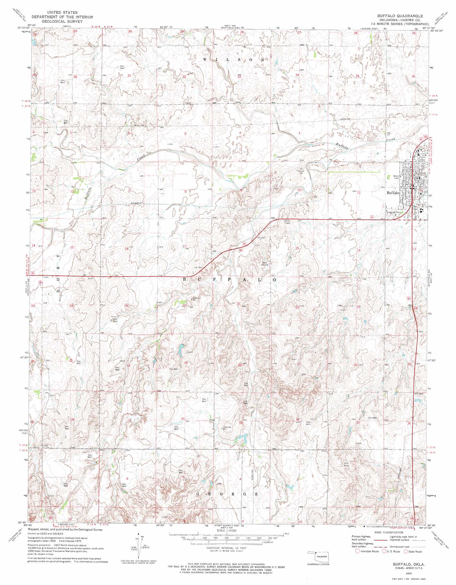
Buffalo Topo Map Oklahoma
To zoom in, hover over the map of Buffalo
USGS Topo Quad 36099g6 - 1:24,000 scale
| Topo Map Name: | Buffalo |
| USGS Topo Quad ID: | 36099g6 |
| Print Size: | ca. 21 1/4" wide x 27" high |
| Southeast Coordinates: | 36.75° N latitude / 99.625° W longitude |
| Map Center Coordinates: | 36.8125° N latitude / 99.6875° W longitude |
| U.S. State: | OK |
| Filename: | o36099g6.jpg |
| Download Map JPG Image: | Buffalo topo map 1:24,000 scale |
| Map Type: | Topographic |
| Topo Series: | 7.5´ |
| Map Scale: | 1:24,000 |
| Source of Map Images: | United States Geological Survey (USGS) |
| Alternate Map Versions: |
Buffalo OK 1970, updated 1973 Download PDF Buy paper map Buffalo OK 2010 Download PDF Buy paper map Buffalo OK 2012 Download PDF Buy paper map Buffalo OK 2016 Download PDF Buy paper map |
1:24,000 Topo Quads surrounding Buffalo
Englewood |
Ashland Se |
Sitka Sw |
Trout Creek |
Protection Sw |
Rosston Nw |
Rosston Ne |
Buffalo Nw |
Buffalo Ne |
Selman Nw |
Rosston |
Rosston Se |
Buffalo |
Buffalo Se |
Selman |
Laverne |
Laverne Ne |
Fort Supply Nw |
Fort Supply Ne |
Sleeping Bear Creek Nw |
Laverne Sw |
May West |
May East |
Fort Supply |
Sleeping Bear Creek Sw |
> Back to 36099e1 at 1:100,000 scale
> Back to 36098a1 at 1:250,000 scale
> Back to U.S. Topo Maps home
Buffalo topo map: Gazetteer
Buffalo: Dams
Oknoname 059039 Dam elevation 588m 1929′Oknoname 059053 Dam elevation 585m 1919′
Oknoname 059062 Dam elevation 594m 1948′
Oknoname 059063 Dam elevation 611m 2004′
Oknoname 059064 Dam elevation 591m 1938′
Oknoname 059065 Dam elevation 594m 1948′
R Wickham Number 4 Dam elevation 593m 1945′
Buffalo: Populated Places
Buffalo elevation 553m 1814′Buffalo: Reservoirs
Oknoname 059039 Reservoir elevation 588m 1929′Oknoname 059053 Reservoir elevation 585m 1919′
Oknoname 059062 Reservoir elevation 594m 1948′
Oknoname 059063 Reservoir elevation 611m 2004′
Oknoname 059064 Reservoir elevation 591m 1938′
Oknoname 059065 Reservoir elevation 594m 1948′
R Wickham Number 4 Reservoir elevation 593m 1945′
Buffalo digital topo map on disk
Buy this Buffalo topo map showing relief, roads, GPS coordinates and other geographical features, as a high-resolution digital map file on DVD: