Ingram Lake Topo Map New Mexico
To zoom in, hover over the map of Ingram Lake
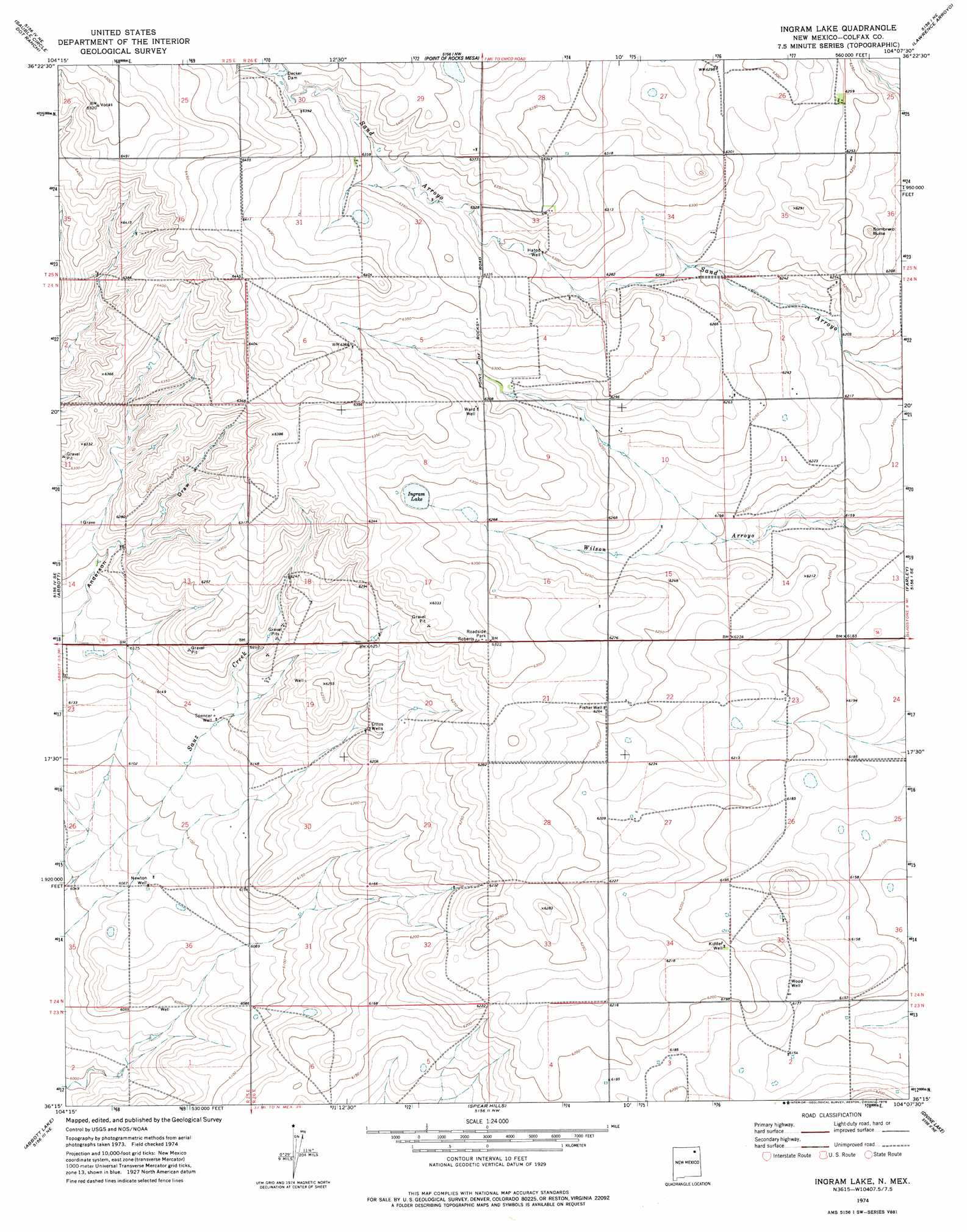
USGS Topo Quad 36104c2 - 1:24,000 scale
| Topo Map Name: | Ingram Lake |
| USGS Topo Quad ID: | 36104c2 |
| Print Size: | ca. 21 1/4" wide x 27" high |
| Southeast Coordinates: | 36.25° N latitude / 104.125° W longitude |
| Map Center Coordinates: | 36.3125° N latitude / 104.1875° W longitude |
| U.S. State: | NM |
| Filename: | o36104c2.jpg |
| Download Map JPG Image: | Ingram Lake topo map 1:24,000 scale |
| Map Type: | Topographic |
| Topo Series: | 7.5´ |
| Map Scale: | 1:24,000 |
| Source of Map Images: | United States Geological Survey (USGS) |
| Alternate Map Versions: |
Ingram Lake NM 1974, updated 1978 Download PDF Buy paper map Ingram Lake NM 2010 Download PDF Buy paper map Ingram Lake NM 2013 Download PDF Buy paper map Ingram Lake NM 2017 Download PDF Buy paper map |
1:24,000 Topo Quads surrounding Ingram Lake
Loco Arroyo |
Tres Hermanos Peak |
Pine Buttes |
Palo Blanco Mountain |
Malpie Mountain |
Abbott Nw |
Sauble Circle Dot Ranch |
Point Of Rocks Mesa |
Lawrence Arroyo |
Gladstone Nw |
Taylor Springs |
Abbott |
Ingram Lake |
Farley |
Gladstone |
Jaritas Ranch |
Abbott Lake |
Spear Hills |
Divine Lake |
Yates |
Canon Colorado |
Mills West |
Mills East |
Kansas Valley |
Valencia Spring |
> Back to 36104a1 at 1:100,000 scale
> Back to 36104a1 at 1:250,000 scale
> Back to U.S. Topo Maps home
Ingram Lake topo map: Gazetteer
Ingram Lake: Dams
Decker Dam elevation 1946m 6384′Ingram Lake: Lakes
Ingram Lake elevation 1916m 6286′Ingram Lake: Post Offices
Abbott Post Office (historical) elevation 1865m 6118′Ingram Lake: Summits
Sombrero Butte elevation 1911m 6269′Ingram Lake: Valleys
Anderson Draw elevation 1881m 6171′Ingram Lake: Wells
Fisher Well elevation 1910m 6266′Hatod Well elevation 1923m 6309′
Kidder Well elevation 1891m 6204′
Newton Well elevation 1851m 6072′
Ottos Wells elevation 1888m 6194′
Spencer Well elevation 1875m 6151′
Ward Well elevation 1927m 6322′
Wood Well elevation 1884m 6181′
Ingram Lake digital topo map on disk
Buy this Ingram Lake topo map showing relief, roads, GPS coordinates and other geographical features, as a high-resolution digital map file on DVD: