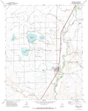
Maxwell Topo Map New Mexico
To zoom in, hover over the map of Maxwell
USGS Topo Quad 36104e5 - 1:24,000 scale
| Topo Map Name: | Maxwell |
| USGS Topo Quad ID: | 36104e5 |
| Print Size: | ca. 21 1/4" wide x 27" high |
| Southeast Coordinates: | 36.5° N latitude / 104.5° W longitude |
| Map Center Coordinates: | 36.5625° N latitude / 104.5625° W longitude |
| U.S. State: | NM |
| Filename: | o36104e5.jpg |
| Download Map JPG Image: | Maxwell topo map 1:24,000 scale |
| Map Type: | Topographic |
| Topo Series: | 7.5´ |
| Map Scale: | 1:24,000 |
| Source of Map Images: | United States Geological Survey (USGS) |
| Alternate Map Versions: |
Maxwell NM 1971, updated 1974 Download PDF Buy paper map Maxwell NM 2010 Download PDF Buy paper map Maxwell NM 2013 Download PDF Buy paper map Maxwell NM 2017 Download PDF Buy paper map |
1:24,000 Topo Quads surrounding Maxwell
> Back to 36104e1 at 1:100,000 scale
> Back to 36104a1 at 1:250,000 scale
> Back to U.S. Topo Maps home
Maxwell topo map: Gazetteer
Maxwell: Canals
Dyke Ditch elevation 1822m 5977′East Thirteen Ditch elevation 1818m 5964′
East Twelve Ditch elevation 1819m 5967′
Highline Ditch elevation 1846m 6056′
Laguna Eagle Tail Lateral elevation 1862m 6108′
Middle Drain Ditch elevation 1806m 5925′
North Drain Ditch elevation 1826m 5990′
North Fourteen Ditch elevation 1840m 6036′
Number 11 and Stubblefield Lateral elevation 1830m 6003′
Number 11 Inflow Canal elevation 1849m 6066′
Number 11 Lateral elevation 1841m 6040′
Number 12 Inflow Canal elevation 1835m 6020′
Number 14 Inflow Canal elevation 1852m 6076′
Number 14 Lateral elevation 1849m 6066′
Red River Ditch elevation 1832m 6010′
Ridge Ditch elevation 1840m 6036′
Siphon Ditch elevation 1866m 6122′
Siphon Lateral elevation 1861m 6105′
South Drain Ditch elevation 1809m 5935′
South Fourteen Ditch elevation 1836m 6023′
Stubblefield Eagle Tail Lateral elevation 1856m 6089′
West Thirteen Ditch elevation 1833m 6013′
Maxwell: Dams
Dam Number 13 elevation 1832m 6010′Dam Number Two elevation 1843m 6046′
Maxwell Number 11 Dam elevation 1843m 6046′
Maxwell Number 12 Dam elevation 1844m 6049′
Maxwell Number 14 Dam elevation 1843m 6046′
Maxwell: Lakes
Number Eleven Lake elevation 1843m 6046′Maxwell: Parks
Maxwell National Wildlife Refuge elevation 1835m 6020′Maxwell: Populated Places
Maxwell elevation 1806m 5925′Maxwell: Post Offices
Maxwell Post Office (historical) elevation 1806m 5925′Maxwell: Reservoirs
Maxwell Number 14 Reservoir elevation 1843m 6046′Number Fourteen lake elevation 1842m 6043′
Number Thirteen Lake elevation 1844m 6049′
Number Twelve Lake elevation 1833m 6013′
Number Twenty Lake elevation 1814m 5951′
Reservoir Number 13 elevation 1832m 6010′
Reservoir Number Two elevation 1843m 6046′
Maxwell: Streams
Crow Creek elevation 1812m 5944′Curtis Creek elevation 1808m 5931′
Kappis Arroyo elevation 1799m 5902′
Loco Arroyo elevation 1815m 5954′
Spring Arroyo elevation 1795m 5889′
Maxwell digital topo map on disk
Buy this Maxwell topo map showing relief, roads, GPS coordinates and other geographical features, as a high-resolution digital map file on DVD:


