Chacon Topo Map New Mexico
To zoom in, hover over the map of Chacon
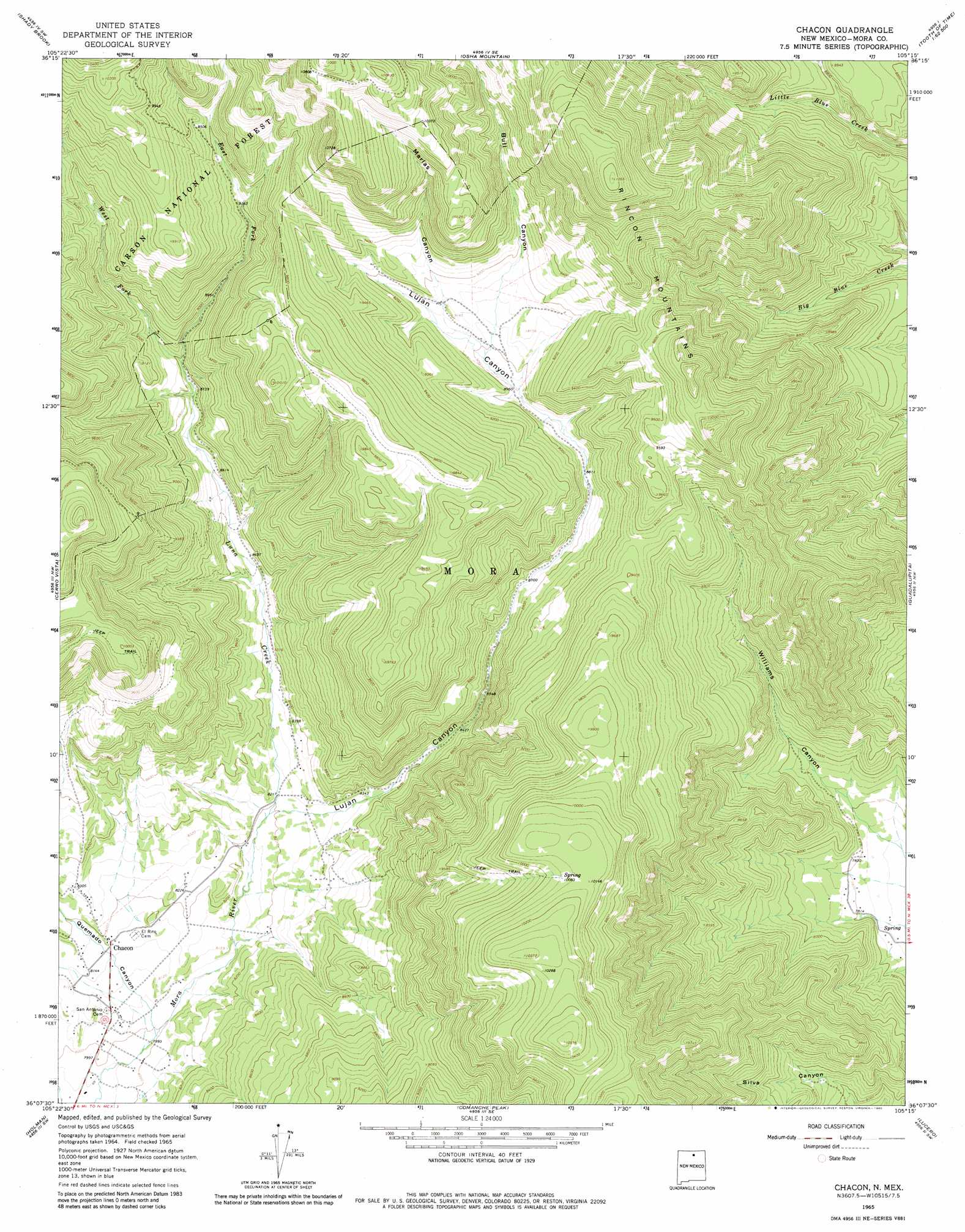
USGS Topo Quad 36105b3 - 1:24,000 scale
| Topo Map Name: | Chacon |
| USGS Topo Quad ID: | 36105b3 |
| Print Size: | ca. 21 1/4" wide x 27" high |
| Southeast Coordinates: | 36.125° N latitude / 105.25° W longitude |
| Map Center Coordinates: | 36.1875° N latitude / 105.3125° W longitude |
| U.S. State: | NM |
| Filename: | o36105b3.jpg |
| Download Map JPG Image: | Chacon topo map 1:24,000 scale |
| Map Type: | Topographic |
| Topo Series: | 7.5´ |
| Map Scale: | 1:24,000 |
| Source of Map Images: | United States Geological Survey (USGS) |
| Alternate Map Versions: |
Chacon NM 1965, updated 1968 Download PDF Buy paper map Chacon NM 1965, updated 1980 Download PDF Buy paper map Chacon NM 1995, updated 1997 Download PDF Buy paper map Chacon NM 2011 Download PDF Buy paper map Chacon NM 2013 Download PDF Buy paper map Chacon NM 2017 Download PDF Buy paper map |
| FStopo: | US Forest Service topo Chacon is available: Download FStopo PDF Download FStopo TIF |
1:24,000 Topo Quads surrounding Chacon
Taos |
Pueblo Peak |
Palo Flechado Pass |
Garcia Peak |
Tooth Of Time |
Ranchos De Taos |
Shady Brook |
Osha Mountain |
Agua Fria Peak |
White Peak |
Tres Ritos |
Cerro Vista |
Chacon |
Guadalupita |
Ocate |
Jicarita Peak |
Holman |
Comanche Peak |
Lucero |
Ojo Feliz |
Pecos Falls |
Gascon |
Mora |
Rainsville |
Fort Union |
> Back to 36105a1 at 1:100,000 scale
> Back to 36104a1 at 1:250,000 scale
> Back to U.S. Topo Maps home
Chacon topo map: Gazetteer
Chacon: Populated Places
Chacon elevation 2489m 8166′Chacon: Post Offices
Chacon Post Office elevation 2489m 8166′Chacon: Streams
East Fork Luna Creek elevation 2678m 8786′Luna Creek elevation 2497m 8192′
West Fork Luna Creek elevation 2678m 8786′
Chacon: Valleys
Bull Canyon elevation 2744m 9002′Lujan Canyon elevation 2507m 8225′
Marias Canyon elevation 2780m 9120′
Quemado Canyon elevation 2439m 8001′
Chacon digital topo map on disk
Buy this Chacon topo map showing relief, roads, GPS coordinates and other geographical features, as a high-resolution digital map file on DVD: