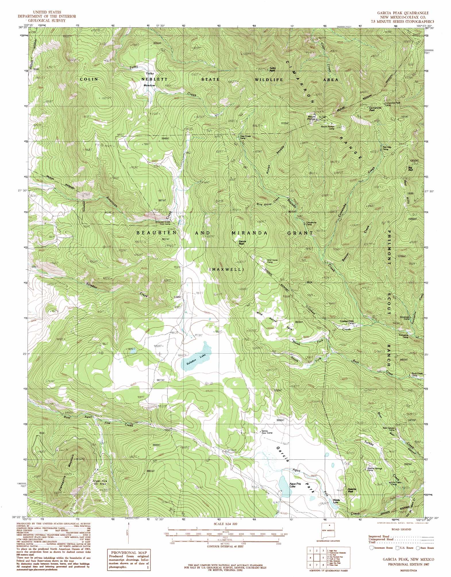
Garcia Peak Topo Map New Mexico
To zoom in, hover over the map of Garcia Peak
USGS Topo Quad 36105d2 - 1:24,000 scale
| Topo Map Name: | Garcia Peak |
| USGS Topo Quad ID: | 36105d2 |
| Print Size: | ca. 21 1/4" wide x 27" high |
| Southeast Coordinates: | 36.375° N latitude / 105.125° W longitude |
| Map Center Coordinates: | 36.4375° N latitude / 105.1875° W longitude |
| U.S. State: | NM |
| Filename: | o36105d2.jpg |
| Download Map JPG Image: | Garcia Peak topo map 1:24,000 scale |
| Map Type: | Topographic |
| Topo Series: | 7.5´ |
| Map Scale: | 1:24,000 |
| Source of Map Images: | United States Geological Survey (USGS) |
| Alternate Map Versions: |
Garcia Peak NM 1994, updated 1998 Download PDF Buy paper map Garcia Peak NM 2010 Download PDF Buy paper map Garcia Peak NM 2013 Download PDF Buy paper map Garcia Peak NM 2017 Download PDF Buy paper map |
1:24,000 Topo Quads surrounding Garcia Peak
Red River |
Red River Pass |
Baldy Mountain |
Abreu Canyon |
House Canyon |
Wheeler Peak |
Eagle Nest |
Touch-Me-Not Mountain |
Ute Park |
Cimarron |
Pueblo Peak |
Palo Flechado Pass |
Garcia Peak |
Tooth Of Time |
Coyote Mesa |
Shady Brook |
Osha Mountain |
Agua Fria Peak |
White Peak |
Rayado |
Cerro Vista |
Chacon |
Guadalupita |
Ocate |
Mora Ranch |
> Back to 36105a1 at 1:100,000 scale
> Back to 36104a1 at 1:250,000 scale
> Back to U.S. Topo Maps home
Garcia Peak topo map: Gazetteer
Garcia Peak: Flats
Tolby Meadow elevation 2901m 9517′Wild Horse Park elevation 3029m 9937′
Garcia Peak: Lakes
Middle Lake elevation 2915m 9563′Saladon Lake elevation 2995m 9826′
Garcia Peak: Mines
Llano Vista elevation 3000m 9842′Garcia Peak: Parks
Garcia Park elevation 2940m 9645′Garcia Peak: Ranges
Cimarron Range elevation 3282m 10767′Garcia Peak: Reservoirs
Agua Fria Lake elevation 2946m 9665′Garcia Peak: Ridges
Red Hills elevation 3256m 10682′Garcia Peak: Streams
Beaver Creek elevation 2863m 9393′Comanche Creek elevation 2904m 9527′
Crooked Creek elevation 2790m 9153′
North Fork Buck Creek elevation 2902m 9520′
Ojo de Maiz Creek elevation 2683m 8802′
Porcupine Creek elevation 2923m 9589′
Rincon Rayado elevation 3022m 9914′
South Fork Buck Creek elevation 2902m 9520′
Turkey Creek elevation 2704m 8871′
Wild Horse Creek elevation 2996m 9829′
Garcia Peak: Summits
Apache Peak elevation 3002m 9849′Bunkhouse Bare Point elevation 3550m 11646′
Cieneguilla Mountain elevation 3226m 10583′
Comanche Peak elevation 3438m 11279′
Garcia Peak elevation 3323m 10902′
Mount Phillips elevation 3553m 11656′
Tolby Peak elevation 3513m 11525′
Garcia Peak digital topo map on disk
Buy this Garcia Peak topo map showing relief, roads, GPS coordinates and other geographical features, as a high-resolution digital map file on DVD: