The Wall Topo Map New Mexico
To zoom in, hover over the map of The Wall
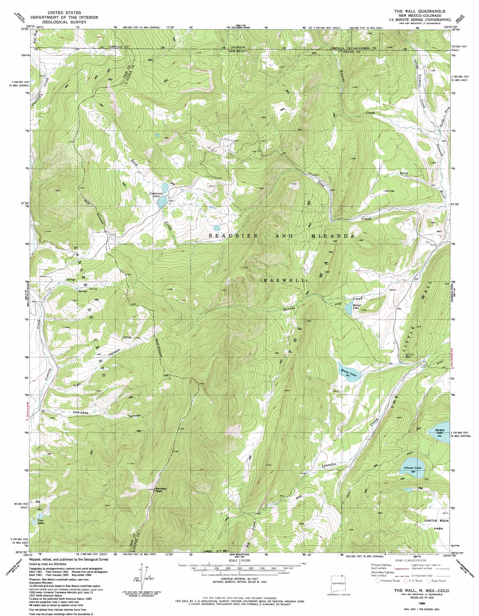
USGS Topo Quad 36105h2 - 1:24,000 scale
| Topo Map Name: | The Wall |
| USGS Topo Quad ID: | 36105h2 |
| Print Size: | ca. 21 1/4" wide x 27" high |
| Southeast Coordinates: | 36.875° N latitude / 105.125° W longitude |
| Map Center Coordinates: | 36.9375° N latitude / 105.1875° W longitude |
| U.S. States: | NM, CO |
| Filename: | o36105h2.jpg |
| Download Map JPG Image: | The Wall topo map 1:24,000 scale |
| Map Type: | Topographic |
| Topo Series: | 7.5´ |
| Map Scale: | 1:24,000 |
| Source of Map Images: | United States Geological Survey (USGS) |
| Alternate Map Versions: |
The Wall NM 1986, updated 1986 Download PDF Buy paper map The Wall NM 1995, updated 1997 Download PDF Buy paper map The Wall NM 2011 Download PDF Buy paper map The Wall NM 2013 Download PDF Buy paper map |
| FStopo: | US Forest Service topo The Wall is available: Download FStopo PDF Download FStopo TIF |
1:24,000 Topo Quads surrounding The Wall
San Luis |
Taylor Ranch |
El Valle Creek |
Stonewall |
Vigil |
Sanchez Reservoir |
La Valley |
Culebra Peak |
Torres |
Tercio |
Amalia |
Big Costilla Peak |
The Wall |
Vermejo Park |
Casa Grande |
Latir Peak |
Comanche Point |
Ash Mountain |
Van Bremmer Park |
Casa Grande Sw |
Red River |
Red River Pass |
Baldy Mountain |
Abreu Canyon |
House Canyon |
> Back to 36105e1 at 1:100,000 scale
> Back to 36104a1 at 1:250,000 scale
> Back to U.S. Topo Maps home
The Wall topo map: Gazetteer
The Wall: Lakes
Adams Lake elevation 2650m 8694′Bartlett Lake elevation 2650m 8694′
Bernal Lake elevation 2641m 8664′
Twin Lakes elevation 2995m 9826′
The Wall: Mines
Van Lint Mine elevation 2571m 8435′The Wall: Populated Places
Banning Place elevation 2528m 8293′The Wall: Reservoirs
Munn Lake elevation 2577m 8454′Underwood Lakes elevation 3043m 9983′
The Wall: Ridges
The Little Wall elevation 2660m 8727′The Wall elevation 2855m 9366′
The Wall: Streams
Elk Creek elevation 2796m 9173′Gold Creek elevation 2505m 8218′
Little Vermejo Creek elevation 2552m 8372′
Little Vermejo Creek elevation 2554m 8379′
North Fork Vermejo River elevation 2552m 8372′
Ricardo Creek elevation 2547m 8356′
The Wall: Summits
Vermejo Peak elevation 3539m 11610′The Wall: Trails
Bernal Trail elevation 3140m 10301′The Wall: Valleys
Cherokee Canyon elevation 2894m 9494′Trail Canyon elevation 2905m 9530′
The Wall digital topo map on disk
Buy this The Wall topo map showing relief, roads, GPS coordinates and other geographical features, as a high-resolution digital map file on DVD: