Ojo Caliente Topo Map New Mexico
To zoom in, hover over the map of Ojo Caliente
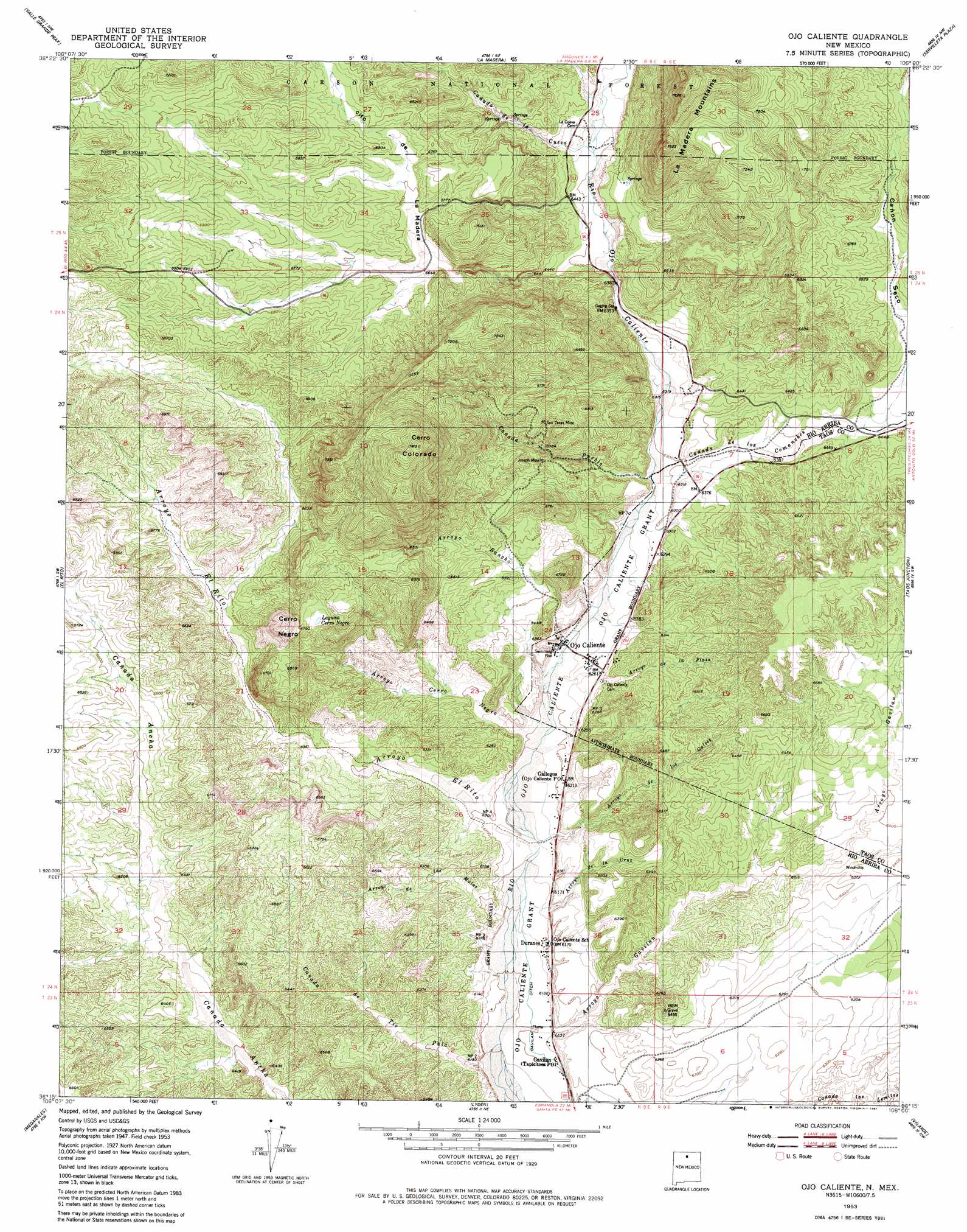
USGS Topo Quad 36106c1 - 1:24,000 scale
| Topo Map Name: | Ojo Caliente |
| USGS Topo Quad ID: | 36106c1 |
| Print Size: | ca. 21 1/4" wide x 27" high |
| Southeast Coordinates: | 36.25° N latitude / 106° W longitude |
| Map Center Coordinates: | 36.3125° N latitude / 106.0625° W longitude |
| U.S. State: | NM |
| Filename: | o36106c1.jpg |
| Download Map JPG Image: | Ojo Caliente topo map 1:24,000 scale |
| Map Type: | Topographic |
| Topo Series: | 7.5´ |
| Map Scale: | 1:24,000 |
| Source of Map Images: | United States Geological Survey (USGS) |
| Alternate Map Versions: |
Ojo Caliente NM 1953, updated 1955 Download PDF Buy paper map Ojo Caliente NM 1953, updated 1957 Download PDF Buy paper map Ojo Caliente NM 1953, updated 1981 Download PDF Buy paper map Ojo Caliente NM 1995, updated 1998 Download PDF Buy paper map Ojo Caliente NM 2011 Download PDF Buy paper map Ojo Caliente NM 2013 Download PDF Buy paper map Ojo Caliente NM 2017 Download PDF Buy paper map |
| FStopo: | US Forest Service topo Ojo Caliente is available: Download FStopo PDF Download FStopo TIF |
1:24,000 Topo Quads surrounding Ojo Caliente
Canjilon Mountain |
Canon Plaza |
Las Tablas |
Petaca Peak |
Cerro De Los Taoses |
Mogote Peak |
Valle Grande Peak |
La Madera |
Servilleta Plaza |
Tres Orejas |
Canjilon Se |
El Rito |
Ojo Caliente |
Taos Junction |
Carson |
Abiquiu |
Medanales |
Lyden |
Velarde |
Trampas |
Vallecitos |
Chili |
San Juan Pueblo |
Chimayo |
Truchas |
> Back to 36106a1 at 1:100,000 scale
> Back to 36106a1 at 1:250,000 scale
> Back to U.S. Topo Maps home
Ojo Caliente topo map: Gazetteer
Ojo Caliente: Canals
Gavilan Ditch elevation 1861m 6105′Ojo Caliente: Lakes
Laguna Cerro Negro elevation 2052m 6732′Ojo Caliente: Mines
Joseph Mine elevation 1999m 6558′Los Compadres elevation 2000m 6561′
Mica Mill elevation 1933m 6341′
San Texas Mine elevation 2034m 6673′
Southwestern Mining elevation 2045m 6709′
Stanko and Springer Property elevation 1924m 6312′
Star Mine elevation 1975m 6479′
Ojo Caliente: Parks
Ojo Caliente Historical Marker elevation 1905m 6250′Ojo Caliente: Populated Places
Duranes elevation 1883m 6177′Gallegos elevation 1896m 6220′
La Cueva (historical) elevation 1970m 6463′
Ojo Caliente elevation 1905m 6250′
Ojo Caliente: Post Offices
Ojo Caliente Post Office elevation 1896m 6220′Tapicitoes Post Office elevation 1865m 6118′
Ojo Caliente: Ranges
La Madera Mountains elevation 2308m 7572′Ojo Caliente: Springs
Iron Spring elevation 1897m 6223′Mineral Springs elevation 1922m 6305′
Ojo Caliente: Streams
Arroyo Cerro Negro elevation 1888m 6194′Arroyo Cruz elevation 1871m 6138′
Arroyo de la Plaza elevation 1913m 6276′
Arroyo de las Mulas elevation 1865m 6118′
Arroyo de los Galves elevation 1875m 6151′
Arroyo el Rito elevation 1877m 6158′
Arroyo Gavilan elevation 1860m 6102′
Arroyo Rancho elevation 1904m 6246′
Cañada de la Cueva elevation 1954m 6410′
Cañada de Tio Pula elevation 1853m 6079′
Cañada los Comanches elevation 1920m 6299′
Cañada Pueblo elevation 1919m 6295′
Desague Aguita elevation 2043m 6702′
Stevens Arroyo elevation 1931m 6335′
Ojo Caliente: Summits
Cerro Colorado elevation 2373m 7785′Cerro Negro elevation 2136m 7007′
Ojo Caliente: Valleys
Cañon Seco elevation 1995m 6545′Cañoncito de la Madera elevation 1943m 6374′
Ojo Caliente: Wells
HC-72529 Water Well elevation 1924m 6312′RG-10037 Water Well elevation 1935m 6348′
RG-1623 Water Well elevation 1854m 6082′
RG-21634 Water Well elevation 1922m 6305′
RG-25727 Water Well elevation 1937m 6354′
RG-27220 Water Well elevation 1946m 6384′
RG-29941 Water Well elevation 1926m 6318′
RG-30340 Water Well elevation 1921m 6302′
RG-31074 Water Well elevation 1931m 6335′
RG-462 Water Well elevation 1904m 6246′
Ojo Caliente digital topo map on disk
Buy this Ojo Caliente topo map showing relief, roads, GPS coordinates and other geographical features, as a high-resolution digital map file on DVD: