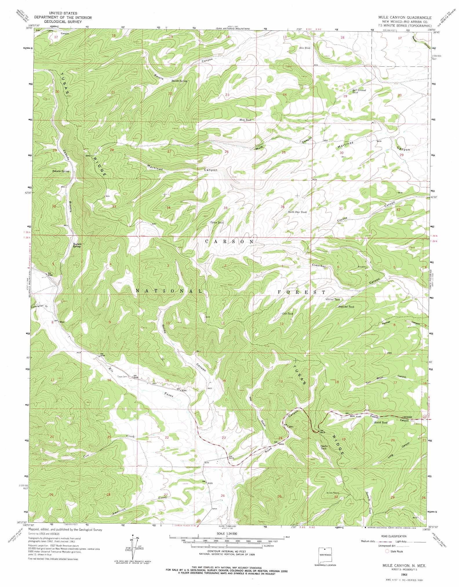
Mule Canyon Topo Map New Mexico
To zoom in, hover over the map of Mule Canyon
USGS Topo Quad 36106f1 - 1:24,000 scale
| Topo Map Name: | Mule Canyon |
| USGS Topo Quad ID: | 36106f1 |
| Print Size: | ca. 21 1/4" wide x 27" high |
| Southeast Coordinates: | 36.625° N latitude / 106° W longitude |
| Map Center Coordinates: | 36.6875° N latitude / 106.0625° W longitude |
| U.S. State: | NM |
| Filename: | o36106f1.jpg |
| Download Map JPG Image: | Mule Canyon topo map 1:24,000 scale |
| Map Type: | Topographic |
| Topo Series: | 7.5´ |
| Map Scale: | 1:24,000 |
| Source of Map Images: | United States Geological Survey (USGS) |
| Alternate Map Versions: |
Mule Canyon NM 1963, updated 1967 Download PDF Buy paper map Mule Canyon NM 1963, updated 1978 Download PDF Buy paper map Mule Canyon NM 1995, updated 1998 Download PDF Buy paper map Mule Canyon NM 2011 Download PDF Buy paper map Mule Canyon NM 2013 Download PDF Buy paper map Mule Canyon NM 2017 Download PDF Buy paper map |
| FStopo: | US Forest Service topo Mule Canyon is available: Download FStopo PDF Download FStopo TIF |
1:24,000 Topo Quads surrounding Mule Canyon
Toltec Mesa |
Bighorn Peak |
Los Pinos |
Pinabetoso Peaks |
La Segita Peaks Ne |
Lagunitas Creek |
Broke Off Mountain |
San Antonio Mountain |
La Segita Peaks |
Cerro De La Olla |
East Gavilan Canyon |
Burned Mountain |
Mule Canyon |
Tres Piedras |
Tres Piedras Ne |
Canjilon Mountain |
Canon Plaza |
Las Tablas |
Petaca Peak |
Cerro De Los Taoses |
Mogote Peak |
Valle Grande Peak |
La Madera |
Servilleta Plaza |
Tres Orejas |
> Back to 36106e1 at 1:100,000 scale
> Back to 36106a1 at 1:250,000 scale
> Back to U.S. Topo Maps home
Mule Canyon topo map: Gazetteer
Mule Canyon: Forests
Tres Piedras Ranger District elevation 2686m 8812′Mule Canyon: Mines
Austin Prospect elevation 2597m 8520′Billy Kennedy elevation 2653m 8704′
Mary L Prospect elevation 2689m 8822′
Milwaukee Belle Prospect elevation 2610m 8562′
Red Fissure elevation 2683m 8802′
Roosevelt Prospect elevation 2717m 8914′
Star Prospect elevation 2659m 8723′
Texas elevation 2666m 8746′
Tom Benton Prospect elevation 2625m 8612′
Virginia Mine elevation 2717m 8914′
Mule Canyon: Post Offices
Tusas Post Office (historical) elevation 2560m 8398′Mule Canyon: Reservoirs
Alex Tank elevation 2593m 8507′Barela Number Two Tank elevation 2626m 8615′
Bear Tank elevation 2705m 8874′
Bicara Tank elevation 2888m 9475′
Bryan Canyon Tank elevation 2609m 8559′
Cabin Tank elevation 2727m 8946′
Carpenter Tank elevation 2559m 8395′
Corral Tank elevation 2625m 8612′
Cow Creek Tank elevation 2655m 8710′
Coyote Tank elevation 2616m 8582′
Cub Tank elevation 2669m 8756′
Daniel Tank elevation 2691m 8828′
Deer Tank elevation 2632m 8635′
Esquibel Tank elevation 2620m 8595′
Guid Tank elevation 2694m 8838′
Gurule Tank elevation 2742m 8996′
Hay Gulch Tank elevation 2607m 8553′
John Tank elevation 2671m 8763′
Kiowa Tank elevation 2725m 8940′
Kutch Tank elevation 2598m 8523′
Lee Roy Tank elevation 2548m 8359′
Long Canyon Tank elevation 2620m 8595′
Martinez Tank elevation 2750m 9022′
Mesa Tank elevation 2740m 8989′
Miller Tank elevation 2653m 8704′
Morman Tank elevation 2557m 8389′
Mule Canyon Tank elevation 2740m 8989′
Negro Tank elevation 2609m 8559′
No Agua Tank elevation 2562m 8405′
North Star Tank elevation 2658m 8720′
Onofre Tank elevation 2652m 8700′
Pat Tank elevation 2599m 8526′
Petaca Tank elevation 2626m 8615′
Prairie Tank elevation 2671m 8763′
Price Smith Tank elevation 2554m 8379′
Reynolds Tank elevation 2554m 8379′
Rico Tank elevation 2548m 8359′
Road Canyon Tank elevation 2675m 8776′
Royal Tank elevation 2787m 9143′
Royals Tank elevation 2626m 8615′
Salt Ground Tank elevation 2572m 8438′
Sambrano Tank elevation 2624m 8608′
Schofield Tank elevation 2731m 8959′
Spring Tank elevation 2670m 8759′
Valdez Tank elevation 2683m 8802′
Mule Canyon: Ridges
Loco Ridge elevation 2744m 9002′Mule Canyon: Springs
Barela Spring elevation 2702m 8864′Biscara Spring elevation 2753m 9032′
Roybals Spring elevation 2673m 8769′
Mule Canyon: Streams
American Creek elevation 2501m 8205′Cañada Biscara elevation 2596m 8517′
Cow Creek elevation 2524m 8280′
Mule Canyon: Valleys
Cunningham Gulch elevation 2593m 8507′Guido Canyon elevation 2527m 8290′
Hay Gulch elevation 2575m 8448′
Mule Canyon elevation 2557m 8389′
Road Canyon elevation 2512m 8241′
Mule Canyon digital topo map on disk
Buy this Mule Canyon topo map showing relief, roads, GPS coordinates and other geographical features, as a high-resolution digital map file on DVD: