Penasco Amarillo Topo Map New Mexico
To zoom in, hover over the map of Penasco Amarillo
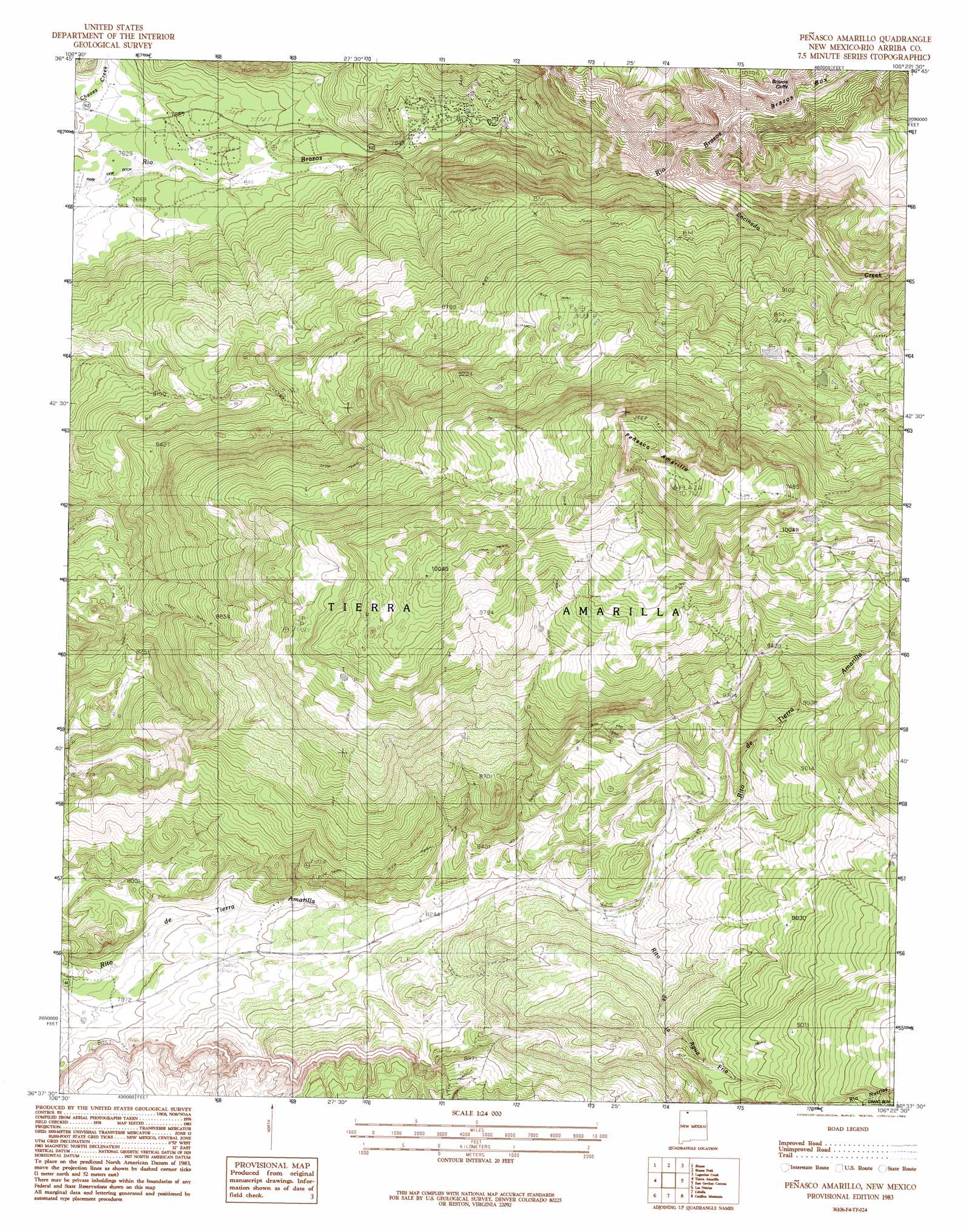
USGS Topo Quad 36106f4 - 1:24,000 scale
| Topo Map Name: | Penasco Amarillo |
| USGS Topo Quad ID: | 36106f4 |
| Print Size: | ca. 21 1/4" wide x 27" high |
| Southeast Coordinates: | 36.625° N latitude / 106.375° W longitude |
| Map Center Coordinates: | 36.6875° N latitude / 106.4375° W longitude |
| U.S. State: | NM |
| Filename: | o36106f4.jpg |
| Download Map JPG Image: | Penasco Amarillo topo map 1:24,000 scale |
| Map Type: | Topographic |
| Topo Series: | 7.5´ |
| Map Scale: | 1:24,000 |
| Source of Map Images: | United States Geological Survey (USGS) |
| Alternate Map Versions: |
Penasco Amarillo NM 1983, updated 1983 Download PDF Buy paper map Penasco Amarillo NM 2011 Download PDF Buy paper map Penasco Amarillo NM 2013 Download PDF Buy paper map Penasco Amarillo NM 2017 Download PDF Buy paper map |
1:24,000 Topo Quads surrounding Penasco Amarillo
Chromo Mountain |
Chama |
West Fork Rio Brazos |
Toltec Mesa |
Bighorn Peak |
Sawmill Mesa |
Brazos |
Brazos Peak |
Lagunitas Creek |
Broke Off Mountain |
Heron Reservoir |
Tierra Amarilla |
Penasco Amarillo |
East Gavilan Canyon |
Burned Mountain |
El Vado |
Las Nutrias |
Cebolla |
Canjilon Mountain |
Canon Plaza |
Navajo Peak |
Alire |
Canjilon |
Mogote Peak |
Valle Grande Peak |
> Back to 36106e1 at 1:100,000 scale
> Back to 36106a1 at 1:250,000 scale
> Back to U.S. Topo Maps home
Penasco Amarillo topo map: Gazetteer
Penasco Amarillo: Airports
Esenada Airport elevation 2336m 7664′Penasco Amarillo: Cliffs
Brazos Cliffs elevation 2991m 9812′Penasco Amarillo: Mines
Dandee Mine elevation 2450m 8038′Upper T.A. Creek elevation 2658m 8720′
Penasco Amarillo: Parks
Brazos Cliffs Historical Marker elevation 2991m 9812′Penasco Amarillo: Streams
Encinado Creek elevation 2493m 8179′Rito de la Agua Fria elevation 2564m 8412′
Penasco Amarillo: Summits
Peñasco Amarillo elevation 3233m 10606′Penasco Amarillo: Valleys
Brazos Box elevation 2493m 8179′Penasco Amarillo digital topo map on disk
Buy this Penasco Amarillo topo map showing relief, roads, GPS coordinates and other geographical features, as a high-resolution digital map file on DVD: