Chromo Mountain Topo Map New Mexico
To zoom in, hover over the map of Chromo Mountain
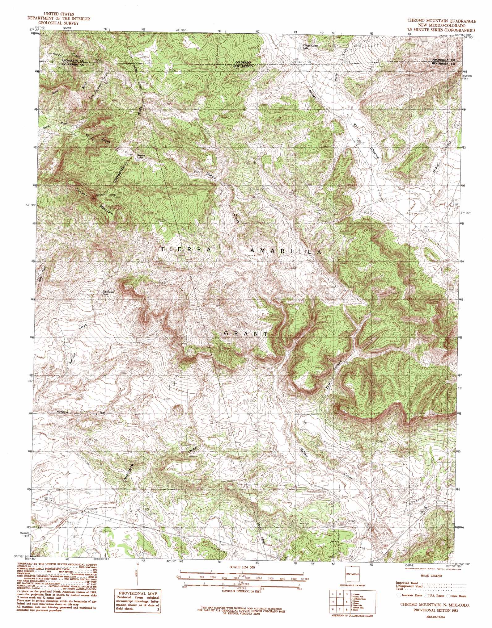
USGS Topo Quad 36106h6 - 1:24,000 scale
| Topo Map Name: | Chromo Mountain |
| USGS Topo Quad ID: | 36106h6 |
| Print Size: | ca. 21 1/4" wide x 27" high |
| Southeast Coordinates: | 36.875° N latitude / 106.625° W longitude |
| Map Center Coordinates: | 36.9375° N latitude / 106.6875° W longitude |
| U.S. States: | NM, CO |
| Filename: | o36106h6.jpg |
| Download Map JPG Image: | Chromo Mountain topo map 1:24,000 scale |
| Map Type: | Topographic |
| Topo Series: | 7.5´ |
| Map Scale: | 1:24,000 |
| Source of Map Images: | United States Geological Survey (USGS) |
| Alternate Map Versions: |
Chromo Mountain NM 1983, updated 1983 Download PDF Buy paper map Chromo Mountain NM 1983, updated 1983 Download PDF Buy paper map Chromo Mountain NM 2010 Download PDF Buy paper map Chromo Mountain NM 2013 Download PDF Buy paper map Chromo Mountain NM 2017 Download PDF Buy paper map |
1:24,000 Topo Quads surrounding Chromo Mountain
Serviceberry Mountain |
Harris Lake |
Elephant Head Rock |
Victoria Lake |
Spectacle Lake |
Edith |
Chromo |
Chama Peak |
Archuleta Creek |
Cumbres |
Dulce |
Monero |
Chromo Mountain |
Chama |
West Fork Rio Brazos |
Cordova Canyon |
Horse Lake |
Sawmill Mesa |
Brazos |
Brazos Peak |
Cedar Canyon |
Apache Mesa |
Heron Reservoir |
Tierra Amarilla |
Penasco Amarillo |
> Back to 36106e1 at 1:100,000 scale
> Back to 36106a1 at 1:250,000 scale
> Back to U.S. Topo Maps home
Chromo Mountain topo map: Gazetteer
Chromo Mountain: Arroyos
Arroyo Salitrar elevation 2325m 7627′Chromo Mountain: Lakes
Beaver Lake elevation 2693m 8835′Las Ranas Lake elevation 2482m 8143′
Chromo Mountain: Populated Places
Willow Creek elevation 2354m 7723′Chromo Mountain: Reservoirs
Clydes Cona Lake elevation 2569m 8428′Chromo Mountain: Ridges
Stove Ridge elevation 2789m 9150′Chromo Mountain: Streams
Estufa Creek elevation 2555m 8382′Las Cuatas Creek elevation 2555m 8382′
Los Cuatas Creek elevation 2572m 8438′
Nabor Creek elevation 2488m 8162′
Nabor Creek elevation 2489m 8166′
Sixto Creek elevation 2537m 8323′
Chromo Mountain: Summits
Chromo Mountain elevation 3006m 9862′Chromo Mountain: Tunnels
Azotea Tunnel elevation 2654m 8707′Azotea Tunnel elevation 2571m 8435′
Chromo Mountain: Valleys
Tuck Canyon elevation 2420m 7939′Chromo Mountain digital topo map on disk
Buy this Chromo Mountain topo map showing relief, roads, GPS coordinates and other geographical features, as a high-resolution digital map file on DVD: