Red Valley Topo Map Arizona
To zoom in, hover over the map of Red Valley
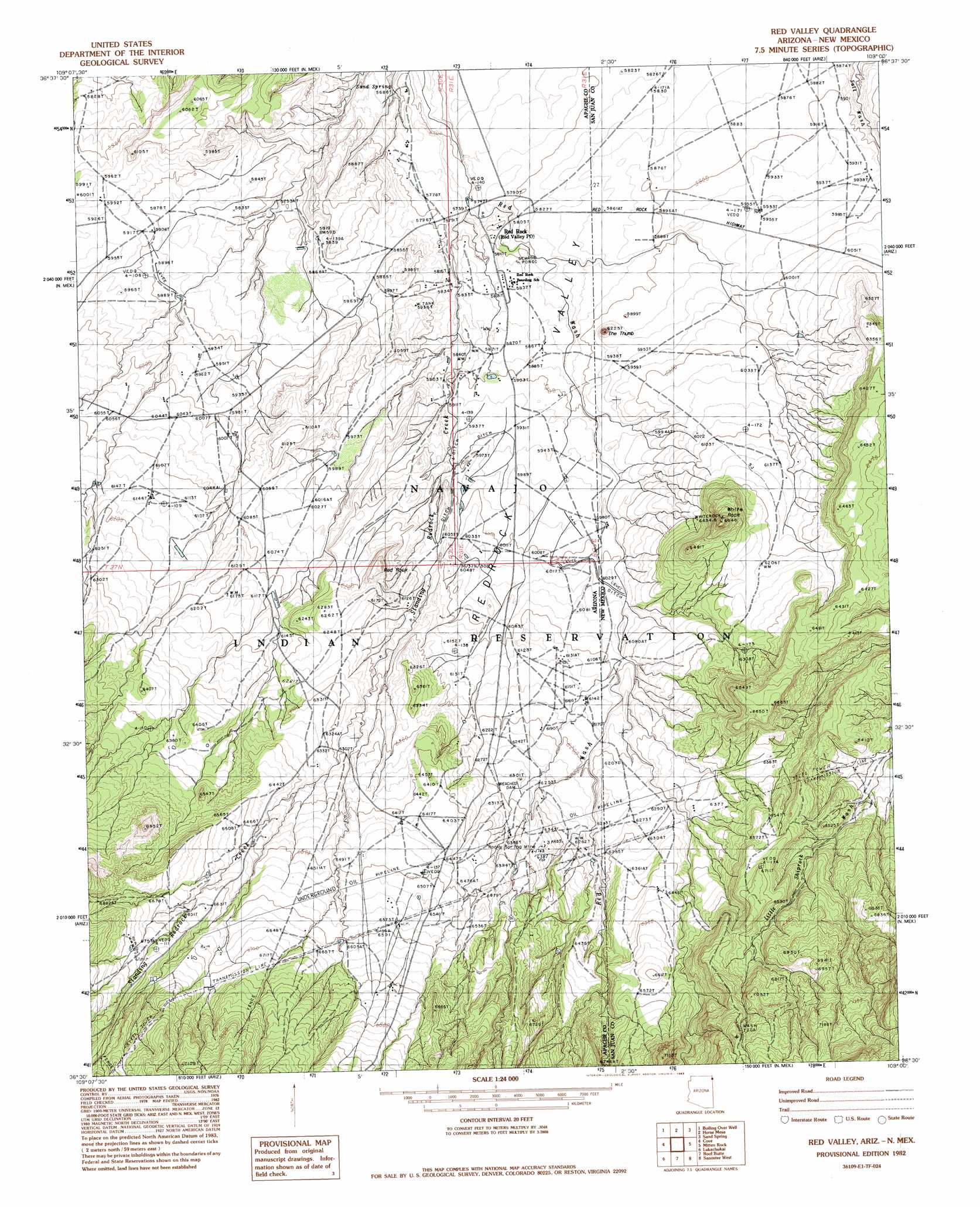
USGS Topo Quad 36109e1 - 1:24,000 scale
| Topo Map Name: | Red Valley |
| USGS Topo Quad ID: | 36109e1 |
| Print Size: | ca. 21 1/4" wide x 27" high |
| Southeast Coordinates: | 36.5° N latitude / 109° W longitude |
| Map Center Coordinates: | 36.5625° N latitude / 109.0625° W longitude |
| U.S. States: | AZ, NM |
| Filename: | o36109e1.jpg |
| Download Map JPG Image: | Red Valley topo map 1:24,000 scale |
| Map Type: | Topographic |
| Topo Series: | 7.5´ |
| Map Scale: | 1:24,000 |
| Source of Map Images: | United States Geological Survey (USGS) |
| Alternate Map Versions: |
Redrock Valley SE AZ 1953, updated 1954 Download PDF Buy paper map Red Valley AZ 1982, updated 1983 Download PDF Buy paper map Red Valley AZ 2010 Download PDF Buy paper map Red Valley AZ 2011 Download PDF Buy paper map Red Valley AZ 2014 Download PDF Buy paper map |
1:24,000 Topo Quads surrounding Red Valley
Toh Chin Lini Mesa |
Pastora Peak |
Beclabito |
Rocky Point |
Rattlesnake |
Kinusta Mesa |
Boiling Over Well |
Horse Mesa |
Sand Spring |
Ship Rock |
Mexican Cry Mesa |
Cove |
Red Valley |
Mitten Rock |
Yellow Hill |
Bad Bug Butte |
Lukachukai |
Roof Butte |
Sanostee West |
Sanostee East |
Red Cornfield Mesa |
Tsaile |
Tsaile Butte |
Old Pine Spring |
Tsin-Nas-Kid |
> Back to 36109e1 at 1:100,000 scale
> Back to 36108a1 at 1:250,000 scale
> Back to U.S. Topo Maps home
Red Valley topo map: Gazetteer
Red Valley: Basins
Red Rock Valley elevation 1800m 5905′Red Valley: Mines
Rocky Spring Mine elevation 1946m 6384′Red Valley: Pillars
The Thumb elevation 1866m 6122′Red Valley: Populated Places
Red Rock elevation 1767m 5797′Red Valley: Springs
Sand Spring elevation 1730m 5675′Red Valley: Streams
Standing Redrock Creek elevation 1748m 5734′Red Valley: Summits
Red Rock elevation 1942m 6371′White Rock elevation 2022m 6633′
Red Valley: Valleys
Red Rock Wash elevation 1749m 5738′Red Valley: Wells
12T-323 Water Well elevation 1812m 5944′12T-564 Water Well elevation 1896m 6220′
Red Valley digital topo map on disk
Buy this Red Valley topo map showing relief, roads, GPS coordinates and other geographical features, as a high-resolution digital map file on DVD: