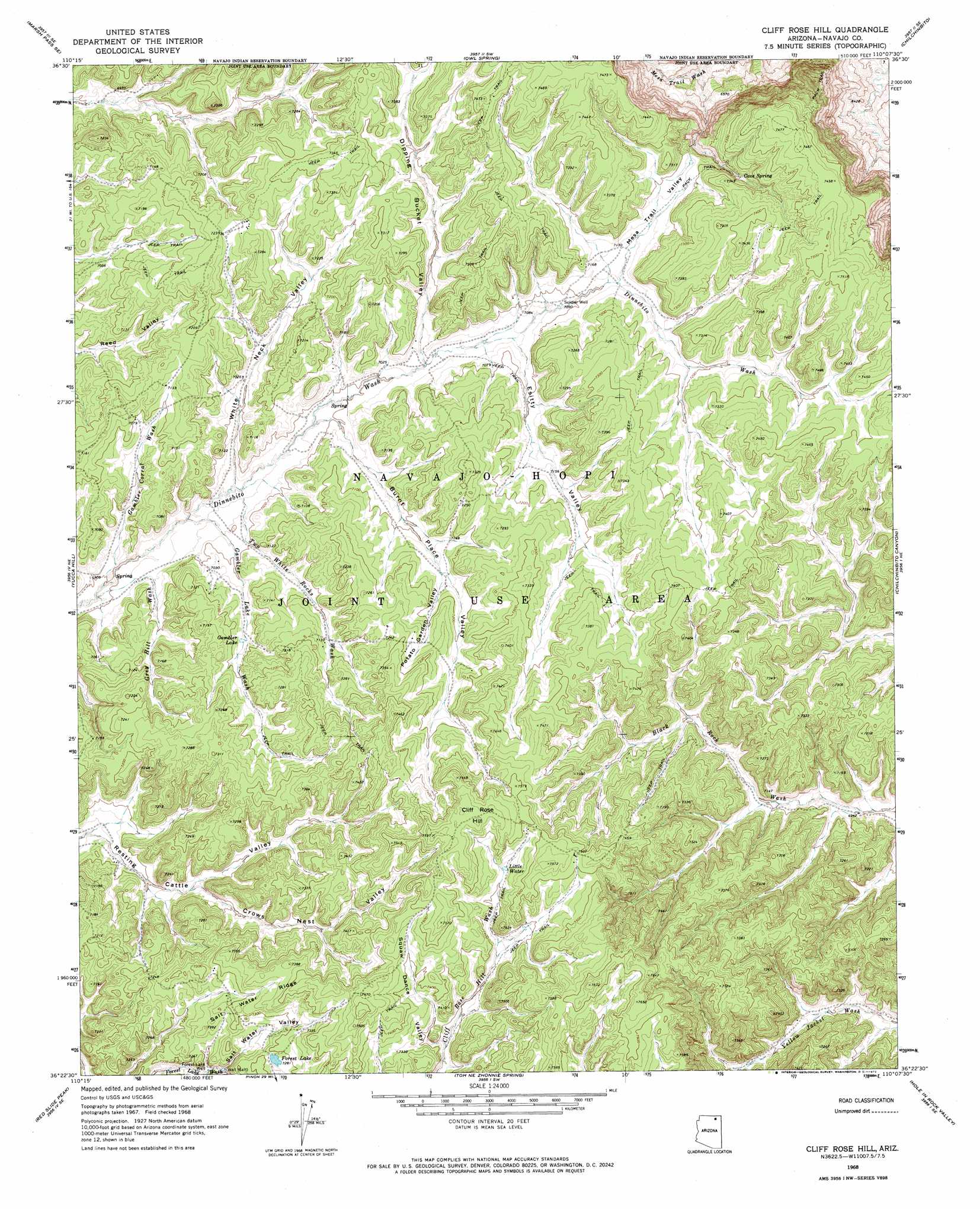
Cliff Rose Hill Topo Map Arizona
To zoom in, hover over the map of Cliff Rose Hill
USGS Topo Quad 36110d2 - 1:24,000 scale
| Topo Map Name: | Cliff Rose Hill |
| USGS Topo Quad ID: | 36110d2 |
| Print Size: | ca. 21 1/4" wide x 27" high |
| Southeast Coordinates: | 36.375° N latitude / 110.125° W longitude |
| Map Center Coordinates: | 36.4375° N latitude / 110.1875° W longitude |
| U.S. State: | AZ |
| Filename: | o36110d2.jpg |
| Download Map JPG Image: | Cliff Rose Hill topo map 1:24,000 scale |
| Map Type: | Topographic |
| Topo Series: | 7.5´ |
| Map Scale: | 1:24,000 |
| Source of Map Images: | United States Geological Survey (USGS) |
| Alternate Map Versions: |
Cliff Rose Hill AZ 1968, updated 1972 Download PDF Buy paper map Cliff Rose Hill AZ 2011 Download PDF Buy paper map Cliff Rose Hill AZ 2014 Download PDF Buy paper map |
1:24,000 Topo Quads surrounding Cliff Rose Hill
Marsh Pass |
Kayenta West |
Kayenta East |
Church Rock |
Red Point Mesa |
Long House Valley |
Marsh Pass Se |
Owl Spring |
Chilchinbito |
Sweetwater Mesa |
Great Spring |
Yucca Hill |
Cliff Rose Hill |
Chilchinbito Canyon |
Rough Rock Nw |
Owl Valley |
Red Slide Peak |
Toh Ne Zhonnie Spring |
Hole In Rock Valley |
Tah Chee Wash |
Big Mountain Dam |
Coat Spring |
Pinon Nw |
Burnt Corn Spring |
Blue Gap |
> Back to 36110a1 at 1:100,000 scale
> Back to 36110a1 at 1:250,000 scale
> Back to U.S. Topo Maps home
Cliff Rose Hill topo map: Gazetteer
Cliff Rose Hill: Lakes
Forest Lake elevation 2224m 7296′Gambler Lake elevation 2156m 7073′
Little Water elevation 2261m 7417′
Cliff Rose Hill: Ridges
Salt Water Ridge elevation 0m 0′Cliff Rose Hill: Springs
Cave Spring elevation 2199m 7214′Cliff Rose Hill: Summits
Cliff Rose Hill elevation 2312m 7585′Cliff Rose Hill: Valleys
Burnt Place Valley elevation 2135m 7004′Crows Nest Valley elevation 2144m 7034′
Dipping Bucket Valley elevation 2147m 7043′
Esitty Valley elevation 2153m 7063′
Gambler Corral Wash elevation 2115m 6938′
Gambler Lake Wash elevation 2129m 6984′
Grey Hill Wash elevation 2115m 6938′
Mesa Trail Valley elevation 2171m 7122′
Potato Garden Valley elevation 2183m 7162′
Salt Water Valley elevation 0m 0′
Squaw Dance Valley elevation 2219m 7280′
Two White Rocks Wash elevation 2129m 6984′
White Neck Valley elevation 2118m 6948′
Cliff Rose Hill: Wells
Forest Lake Well elevation 2185m 7168′Soldier Well elevation 2160m 7086′
Cliff Rose Hill digital topo map on disk
Buy this Cliff Rose Hill topo map showing relief, roads, GPS coordinates and other geographical features, as a high-resolution digital map file on DVD: