Betatakin Ruin Topo Map Arizona
To zoom in, hover over the map of Betatakin Ruin
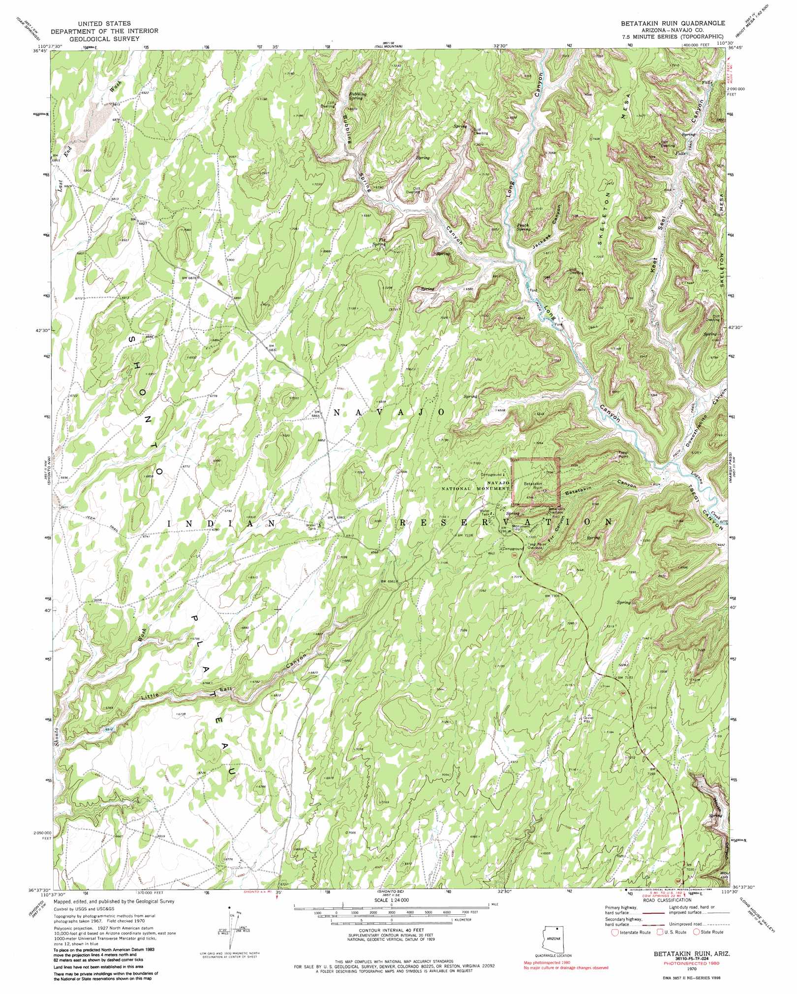
USGS Topo Quad 36110f5 - 1:24,000 scale
| Topo Map Name: | Betatakin Ruin |
| USGS Topo Quad ID: | 36110f5 |
| Print Size: | ca. 21 1/4" wide x 27" high |
| Southeast Coordinates: | 36.625° N latitude / 110.5° W longitude |
| Map Center Coordinates: | 36.6875° N latitude / 110.5625° W longitude |
| U.S. State: | AZ |
| Filename: | o36110f5.jpg |
| Download Map JPG Image: | Betatakin Ruin topo map 1:24,000 scale |
| Map Type: | Topographic |
| Topo Series: | 7.5´ |
| Map Scale: | 1:24,000 |
| Source of Map Images: | United States Geological Survey (USGS) |
| Alternate Map Versions: |
Betatakin Ruin AZ 1970, updated 1973 Download PDF Buy paper map Betatakin Ruin AZ 1970, updated 1985 Download PDF Buy paper map Bubbling Spring Canyon AZ 2011 Download PDF Buy paper map Bubbling Spring Canyon AZ 2014 Download PDF Buy paper map |
1:24,000 Topo Quads surrounding Betatakin Ruin
Chaiyahi Rim Ne |
Tall Mountain Nw |
Cattle Canyon |
Big Point |
Boot Mesa |
Chaiyahi Rim Se |
Oak Springs |
Tall Mountain |
Keet Seel Ruin |
Tseyi-Hatsosi |
Inscription House Ruin |
Shonto Nw |
Betatakin Ruin |
Marsh Pass |
Kayenta West |
Whirlwind Rock |
Shonto |
Shonto Se |
Long House Valley |
Marsh Pass Se |
Cow Springs |
Black Mesa Wash Nw |
Black Mesa Wash Ne |
Great Spring |
Yucca Hill |
> Back to 36110e1 at 1:100,000 scale
> Back to 36110a1 at 1:250,000 scale
> Back to U.S. Topo Maps home
Betatakin Ruin topo map: Gazetteer
Betatakin Ruin: Cliffs
Tsegi Point elevation 2130m 6988′Betatakin Ruin: Parks
Navajo National Monument elevation 2198m 7211′Betatakin Ruin: Populated Places
Betatakin Overlook elevation 2124m 6968′Betatakin Ruin: Springs
Boiling Spring elevation 2222m 7290′Bubbling Spring elevation 2023m 6637′
Fir Spring elevation 2105m 6906′
Peach Spring elevation 2001m 6564′
Betatakin Ruin: Valleys
Betatakin Canyon elevation 1940m 6364′Bubbling Spring Canyon elevation 1989m 6525′
Dowozhiebito Canyon elevation 1928m 6325′
Fir Canyon elevation 1973m 6473′
Jackass Canyon elevation 1986m 6515′
Keet Seel Canyon elevation 1939m 6361′
Little Salt Canyon elevation 1974m 6476′
Long Canyon elevation 1927m 6322′
Betatakin Ruin digital topo map on disk
Buy this Betatakin Ruin topo map showing relief, roads, GPS coordinates and other geographical features, as a high-resolution digital map file on DVD: