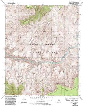
Cape Royal Topo Map Arizona
To zoom in, hover over the map of Cape Royal
USGS Topo Quad 36111a8 - 1:24,000 scale
| Topo Map Name: | Cape Royal |
| USGS Topo Quad ID: | 36111a8 |
| Print Size: | ca. 21 1/4" wide x 27" high |
| Southeast Coordinates: | 36° N latitude / 111.875° W longitude |
| Map Center Coordinates: | 36.0625° N latitude / 111.9375° W longitude |
| U.S. State: | AZ |
| Filename: | o36111a8.jpg |
| Download Map JPG Image: | Cape Royal topo map 1:24,000 scale |
| Map Type: | Topographic |
| Topo Series: | 7.5´ |
| Map Scale: | 1:24,000 |
| Source of Map Images: | United States Geological Survey (USGS) |
| Alternate Map Versions: |
Cape Royal AZ 1988, updated 1988 Download PDF Buy paper map Cape Royal AZ 1988, updated 1988 Download PDF Buy paper map Cape Royal AZ 2011 Download PDF Buy paper map Cape Royal AZ 2014 Download PDF Buy paper map |
| FStopo: | US Forest Service topo Cape Royal is available: Download FStopo PDF Download FStopo TIF |
1:24,000 Topo Quads surrounding Cape Royal
> Back to 36111a1 at 1:100,000 scale
> Back to 36110a1 at 1:250,000 scale
> Back to U.S. Topo Maps home
Cape Royal topo map: Gazetteer
Cape Royal: Arches
Angels Window elevation 2353m 7719′Cape Royal: Cliffs
Ayer Point elevation 1474m 4835′Cape Royal elevation 2335m 7660′
Moran Point elevation 2148m 7047′
Zuni Point elevation 2150m 7053′
Cape Royal: Mines
Hance Mine elevation 957m 3139′Last Chance Mine elevation 1413m 4635′
Cape Royal: Rapids
Hance Rapids elevation 789m 2588′Nevills Rapids elevation 0m 0′
Seventy-Five Mile Rapids elevation 787m 2582′
Sockdolager Rapids elevation 774m 2539′
Cape Royal: Springs
Cliff Spring elevation 2346m 7696′O'Neill Spring (historical) elevation 1387m 4550′
Page Spring elevation 1319m 4327′
Cape Royal: Streams
Cottonwood Creek elevation 800m 2624′Escalante Creek elevation 787m 2582′
Hance Creek elevation 837m 2746′
Papago Creek elevation 786m 2578′
Seventyfive Mile Creek elevation 0m 0′
Vishnu Creek elevation 771m 2529′
Cape Royal: Summits
Angels Gate elevation 1957m 6420′Apollo Temple elevation 1867m 6125′
Coronado Butte elevation 2109m 6919′
Dunn Butte elevation 1657m 5436′
Freya Castle elevation 2188m 7178′
Hall Butte elevation 1650m 5413′
Hollenback Point elevation 2220m 7283′
Horseshoe Mesa elevation 1552m 5091′
Krishna Shrine elevation 1834m 6017′
Newberry Butte elevation 1552m 5091′
Papago Point elevation 2220m 7283′
Rama Shrine elevation 1952m 6404′
Sheba Temple elevation 0m 0′
Solomon Temple elevation 1541m 5055′
The Tabernacle elevation 1450m 4757′
Venus Temple elevation 1886m 6187′
Vishnu Temple elevation 2191m 7188′
Wotans Throne elevation 2327m 7634′
Cape Royal: Trails
Grandview Trail elevation 1500m 4921′Hance Trail elevation 1148m 3766′
Cape Royal: Valleys
Asbestos Canyon elevation 833m 2732′Hance Canyon elevation 774m 2539′
Mineral Canyon elevation 805m 2641′
Red Canyon elevation 815m 2673′
Cape Royal digital topo map on disk
Buy this Cape Royal topo map showing relief, roads, GPS coordinates and other geographical features, as a high-resolution digital map file on DVD:


