Cedar Ridge Topo Map Arizona
To zoom in, hover over the map of Cedar Ridge
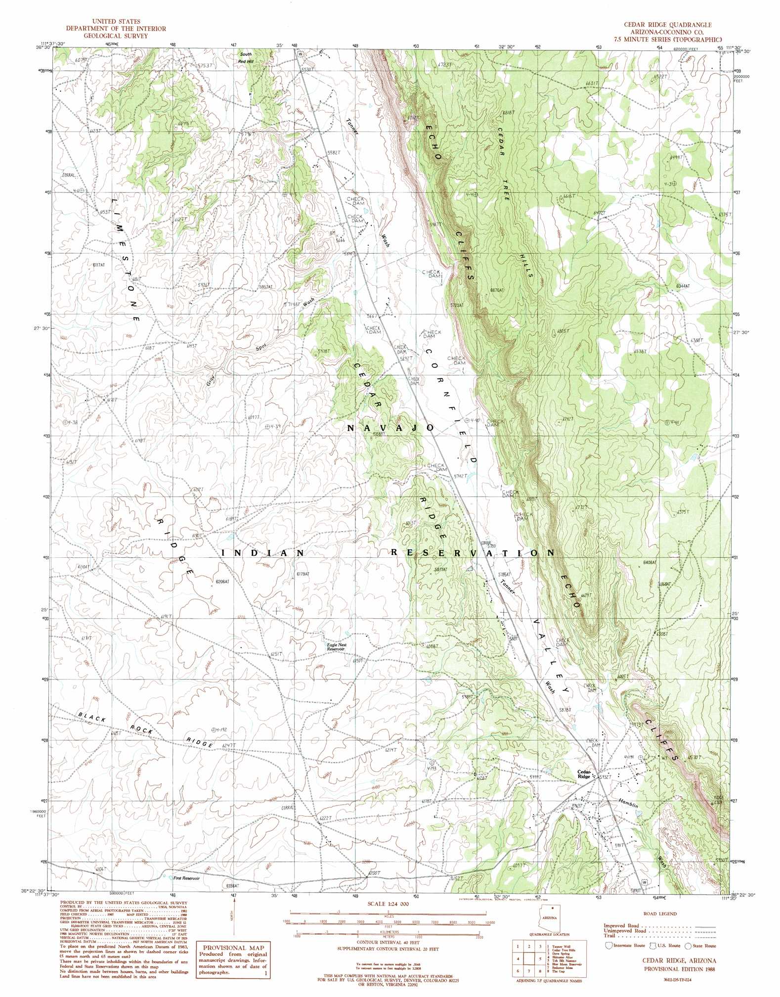
USGS Topo Quad 36111d5 - 1:24,000 scale
| Topo Map Name: | Cedar Ridge |
| USGS Topo Quad ID: | 36111d5 |
| Print Size: | ca. 21 1/4" wide x 27" high |
| Southeast Coordinates: | 36.375° N latitude / 111.5° W longitude |
| Map Center Coordinates: | 36.4375° N latitude / 111.5625° W longitude |
| U.S. State: | AZ |
| Filename: | o36111d5.jpg |
| Download Map JPG Image: | Cedar Ridge topo map 1:24,000 scale |
| Map Type: | Topographic |
| Topo Series: | 7.5´ |
| Map Scale: | 1:24,000 |
| Source of Map Images: | United States Geological Survey (USGS) |
| Alternate Map Versions: |
Shinumo Altar NE AZ 1954, updated 1955 Download PDF Buy paper map Cedar Ridge AZ 1988, updated 1988 Download PDF Buy paper map Cedar Ridge AZ 2011 Download PDF Buy paper map Cedar Ridge AZ 2014 Download PDF Buy paper map |
1:24,000 Topo Quads surrounding Cedar Ridge
Emmett Wash |
Bitter Springs |
Explosive Rock |
Dead Monkey Ridge |
Many Ghosts Hill |
North Canyon Point |
Tanner Well |
Cedar Tree Hills |
Dove Spring |
Dove Spring Se |
Tatahatso Point |
Shinumo Altar |
Cedar Ridge |
Toh Bih Nosteny |
Sitting Coyote Hill |
Nankoweap Mesa |
Blue Moon Reservoir |
Bodaway Mesa |
The Gap |
Preston Well |
Cape Solitude |
Salt Trail Canyon |
Pillow Mountain |
Willow Springs |
Moenave |
> Back to 36111a1 at 1:100,000 scale
> Back to 36110a1 at 1:250,000 scale
> Back to U.S. Topo Maps home
Cedar Ridge topo map: Gazetteer
Cedar Ridge: Cliffs
Echo Cliffs elevation 1865m 6118′Cedar Ridge: Reservoirs
Eagle Nest Reservoir elevation 1883m 6177′First Reservoir elevation 1873m 6145′
McClellan Tanks elevation 1773m 5816′
Cedar Ridge: Ridges
Cedar Ridge elevation 1759m 5770′Cedar Ridge: Streams
Gray Spot Wash elevation 1717m 5633′Cedar Ridge: Summits
South Red Hill elevation 1755m 5757′Cedar Ridge digital topo map on disk
Buy this Cedar Ridge topo map showing relief, roads, GPS coordinates and other geographical features, as a high-resolution digital map file on DVD: