Emmett Hill Topo Map Arizona
To zoom in, hover over the map of Emmett Hill
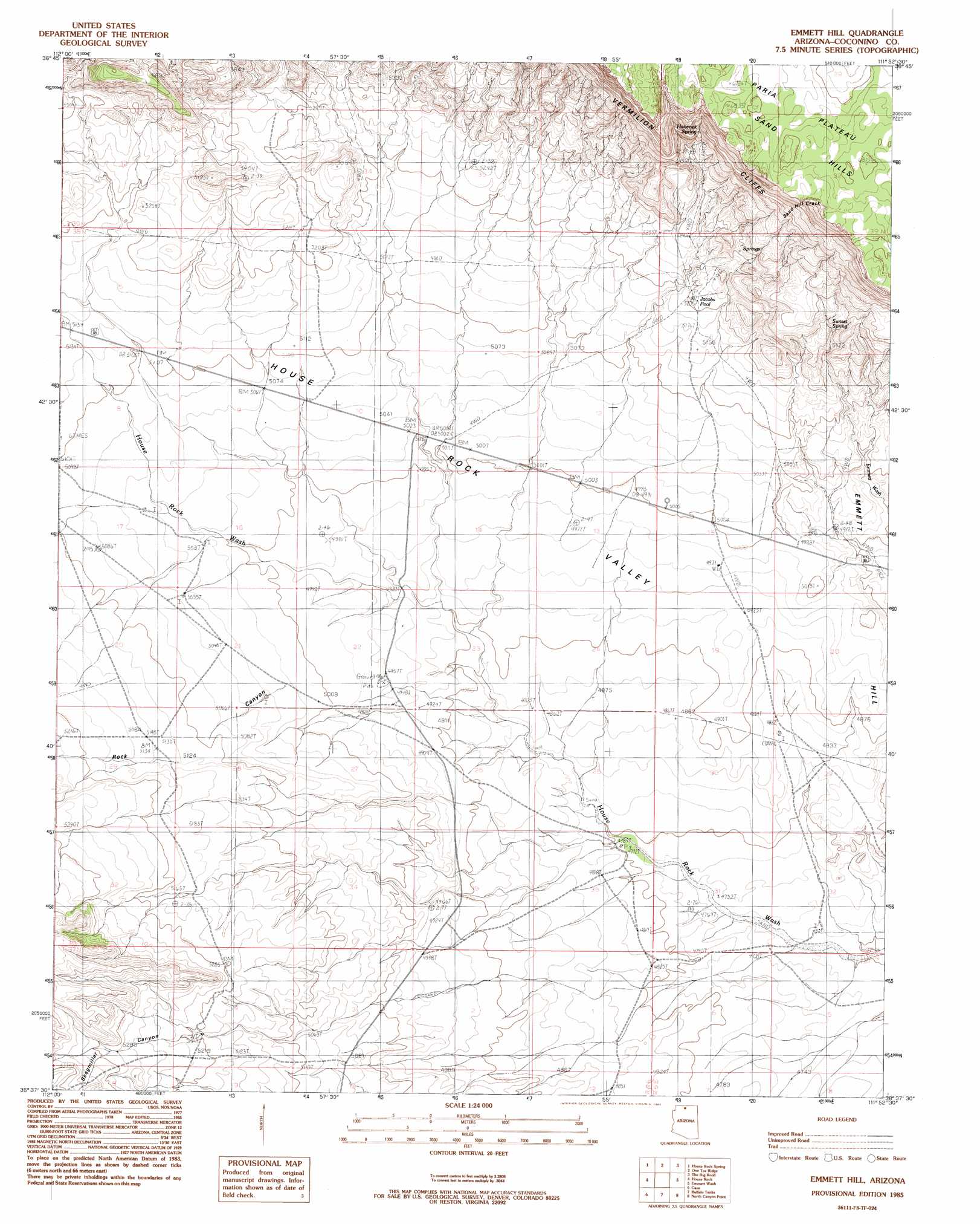
USGS Topo Quad 36111f8 - 1:24,000 scale
| Topo Map Name: | Emmett Hill |
| USGS Topo Quad ID: | 36111f8 |
| Print Size: | ca. 21 1/4" wide x 27" high |
| Southeast Coordinates: | 36.625° N latitude / 111.875° W longitude |
| Map Center Coordinates: | 36.6875° N latitude / 111.9375° W longitude |
| U.S. State: | AZ |
| Filename: | o36111f8.jpg |
| Download Map JPG Image: | Emmett Hill topo map 1:24,000 scale |
| Map Type: | Topographic |
| Topo Series: | 7.5´ |
| Map Scale: | 1:24,000 |
| Source of Map Images: | United States Geological Survey (USGS) |
| Alternate Map Versions: |
Emmett Wash NW AZ 1954, updated 1955 Download PDF Buy paper map Emmett Hill AZ 1985, updated 1985 Download PDF Buy paper map Emmett Hill AZ 2011 Download PDF Buy paper map Emmett Hill AZ 2014 Download PDF Buy paper map |
| FStopo: | US Forest Service topo Emmett Hill is available: Download FStopo PDF Download FStopo TIF |
1:24,000 Topo Quads surrounding Emmett Hill
Buck Pasture Canyon |
Coyote Buttes |
Poverty Flat |
Wrather Arch |
Water Pockets |
Cooper Ridge |
House Rock Spring |
One Toe Ridge |
The Big Knoll |
Navajo Bridge |
Jacob Lake |
House Rock |
Emmett Hill |
Emmett Wash |
Bitter Springs |
Telephone Hill |
Cane |
Buffalo Tanks |
North Canyon Point |
Tanner Well |
De Motte Park |
Dog Point |
Buffalo Ranch |
Tatahatso Point |
Shinumo Altar |
> Back to 36111e1 at 1:100,000 scale
> Back to 36110a1 at 1:250,000 scale
> Back to U.S. Topo Maps home
Emmett Hill topo map: Gazetteer
Emmett Hill: Gaps
Sand Hill Crack elevation 0m 0′Emmett Hill: Lakes
Jacobs Pool elevation 1590m 5216′Emmett Hill: Reservoirs
Anderson Tank elevation 1463m 4799′Blue Clay Reservoir elevation 1608m 5275′
Emmett Hill: Springs
Emmett Spring elevation 1575m 5167′Hancock Spring elevation 1785m 5856′
Sunset Spring elevation 1636m 5367′
Emmett Hill: Streams
Emmett Wash elevation 1498m 4914′Emmett Hill: Summits
Emmett Hill elevation 1520m 4986′Emmett Hill: Valleys
Rock Canyon elevation 1498m 4914′Seegmiller Canyon elevation 0m 0′
Emmett Hill digital topo map on disk
Buy this Emmett Hill topo map showing relief, roads, GPS coordinates and other geographical features, as a high-resolution digital map file on DVD: