One Toe Ridge Topo Map Arizona
To zoom in, hover over the map of One Toe Ridge
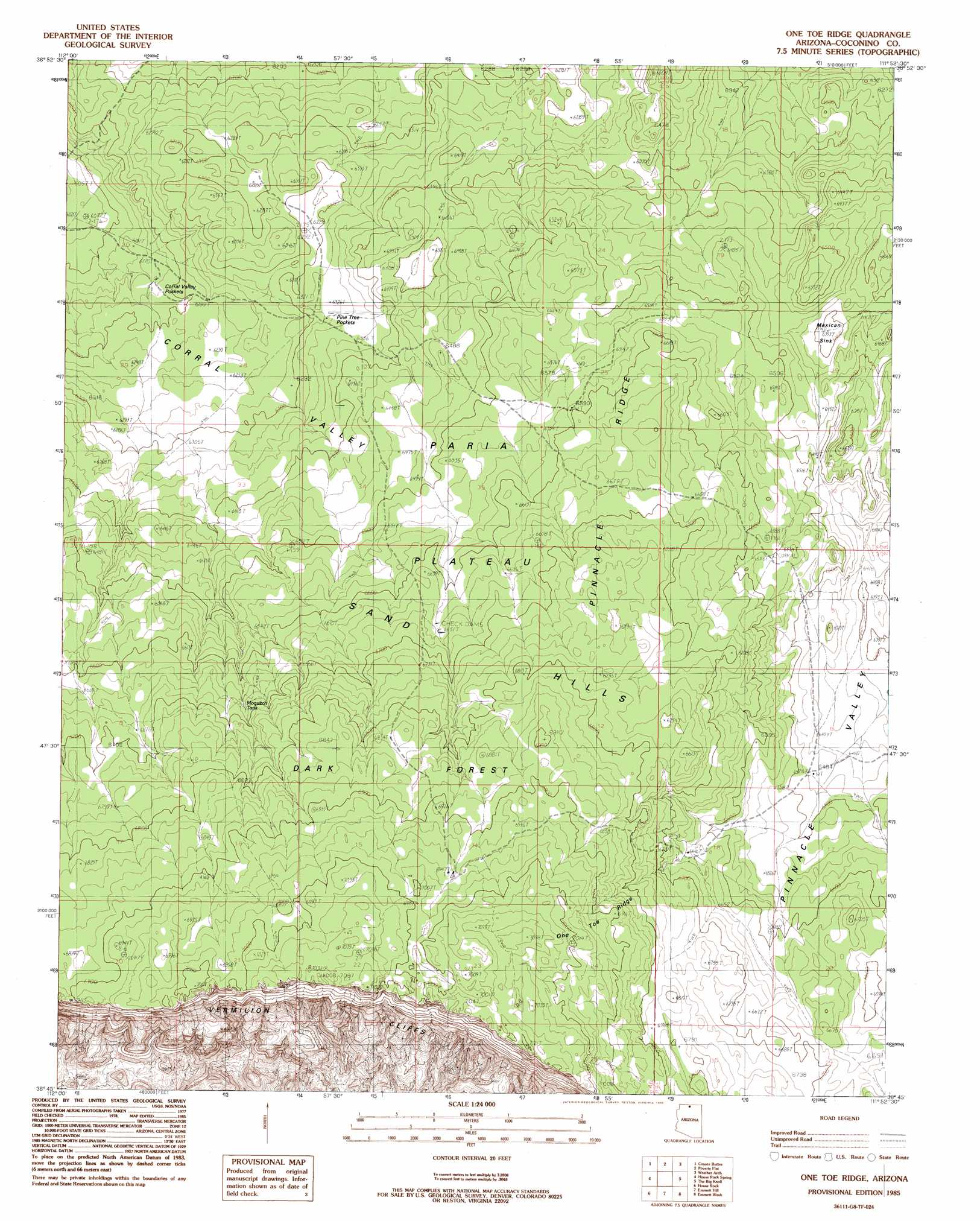
USGS Topo Quad 36111g8 - 1:24,000 scale
| Topo Map Name: | One Toe Ridge |
| USGS Topo Quad ID: | 36111g8 |
| Print Size: | ca. 21 1/4" wide x 27" high |
| Southeast Coordinates: | 36.75° N latitude / 111.875° W longitude |
| Map Center Coordinates: | 36.8125° N latitude / 111.9375° W longitude |
| U.S. State: | AZ |
| Filename: | o36111g8.jpg |
| Download Map JPG Image: | One Toe Ridge topo map 1:24,000 scale |
| Map Type: | Topographic |
| Topo Series: | 7.5´ |
| Map Scale: | 1:24,000 |
| Source of Map Images: | United States Geological Survey (USGS) |
| Alternate Map Versions: |
Paria Plateau SW AZ 1954, updated 1955 Download PDF Buy paper map One Toe Ridge AZ 1985, updated 1985 Download PDF Buy paper map One Toe Ridge AZ 2011 Download PDF Buy paper map One Toe Ridge AZ 2014 Download PDF Buy paper map |
1:24,000 Topo Quads surrounding One Toe Ridge
Petrified Hollow |
Pine Hollow Canyon |
West Clark Bench |
Bridger Point |
Glen Canyon City |
Buck Pasture Canyon |
Coyote Buttes |
Poverty Flat |
Wrather Arch |
Water Pockets |
Cooper Ridge |
House Rock Spring |
One Toe Ridge |
The Big Knoll |
Navajo Bridge |
Jacob Lake |
House Rock |
Emmett Hill |
Emmett Wash |
Bitter Springs |
Telephone Hill |
Cane |
Buffalo Tanks |
North Canyon Point |
Tanner Well |
> Back to 36111e1 at 1:100,000 scale
> Back to 36110a1 at 1:250,000 scale
> Back to U.S. Topo Maps home
One Toe Ridge topo map: Gazetteer
One Toe Ridge: Basins
Pine Tree Pockets elevation 1935m 6348′One Toe Ridge: Flats
Mexican Sink elevation 1950m 6397′One Toe Ridge: Parks
Vermilion Cliffs National Monument elevation 1921m 6302′One Toe Ridge: Plains
Paria Plateau elevation 2006m 6581′One Toe Ridge: Ranges
Sand Hills elevation 0m 0′One Toe Ridge: Reservoirs
Badger Tank elevation 2035m 6676′Moquitch Tank elevation 2033m 6669′
One Toe Ridge: Ridges
One Toe Ridge elevation 2113m 6932′Pinnacle Ridge elevation 2024m 6640′
One Toe Ridge: Valleys
Pinnacle Valley elevation 2015m 6610′One Toe Ridge digital topo map on disk
Buy this One Toe Ridge topo map showing relief, roads, GPS coordinates and other geographical features, as a high-resolution digital map file on DVD: