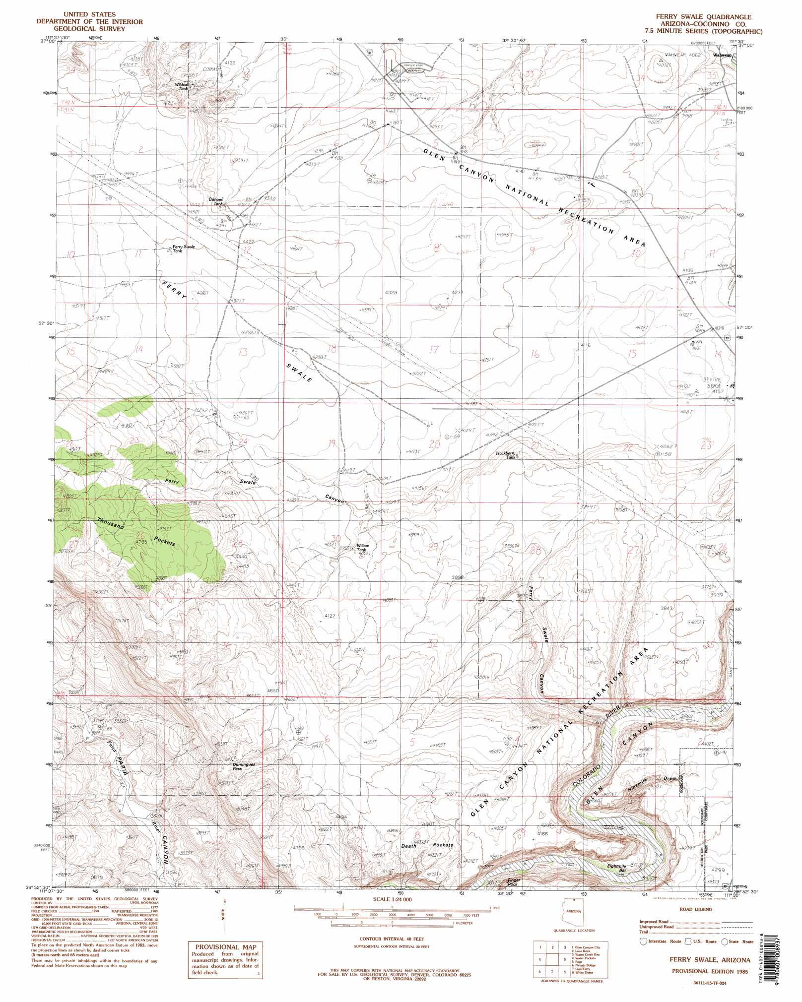
Ferry Swale Topo Map Arizona
To zoom in, hover over the map of Ferry Swale
USGS Topo Quad 36111h5 - 1:24,000 scale
| Topo Map Name: | Ferry Swale |
| USGS Topo Quad ID: | 36111h5 |
| Print Size: | ca. 21 1/4" wide x 27" high |
| Southeast Coordinates: | 36.875° N latitude / 111.5° W longitude |
| Map Center Coordinates: | 36.9375° N latitude / 111.5625° W longitude |
| U.S. State: | AZ |
| Filename: | o36111h5.jpg |
| Download Map JPG Image: | Ferry Swale topo map 1:24,000 scale |
| Map Type: | Topographic |
| Topo Series: | 7.5´ |
| Map Scale: | 1:24,000 |
| Source of Map Images: | United States Geological Survey (USGS) |
| Alternate Map Versions: |
Lees Ferry NE AZ 1951, updated 1955 Download PDF Buy paper map Ferry Swale AZ 1985, updated 1985 Download PDF Buy paper map Ferry Swale AZ 1997, updated 2003 Download PDF Buy paper map Ferry Swale AZ 2011 Download PDF Buy paper map Ferry Swale AZ 2011 Download PDF Buy paper map Ferry Swale AZ 2014 Download PDF Buy paper map |
1:24,000 Topo Quads surrounding Ferry Swale
Lower Coyote Spring |
Nipple Butte |
Tibbet Bench |
Smoky Hollow |
Sit Down Bench |
Bridger Point |
Glen Canyon City |
Lone Rock |
Warm Creek Bay |
Gunsight Butte |
Wrather Arch |
Water Pockets |
Ferry Swale |
Page |
Wild Horse Mesa |
The Big Knoll |
Navajo Bridge |
Lees Ferry |
White Dome |
Leche-E Rock |
Emmett Wash |
Bitter Springs |
Explosive Rock |
Dead Monkey Ridge |
Many Ghosts Hill |
> Back to 36111e1 at 1:100,000 scale
> Back to 36110a1 at 1:250,000 scale
> Back to U.S. Topo Maps home
Ferry Swale topo map: Gazetteer
Ferry Swale: Basins
Thousand Pockets elevation 1459m 4786′Ferry Swale: Reservoirs
Bishops Tank elevation 1352m 4435′Willow Tank elevation 1208m 3963′
Ferry Swale: Valleys
Ferry Swale elevation 1257m 4124′Ferry Swale Canyon elevation 977m 3205′
Ferry Swale digital topo map on disk
Buy this Ferry Swale topo map showing relief, roads, GPS coordinates and other geographical features, as a high-resolution digital map file on DVD: