Grand Canyon Topo Map Arizona
To zoom in, hover over the map of Grand Canyon
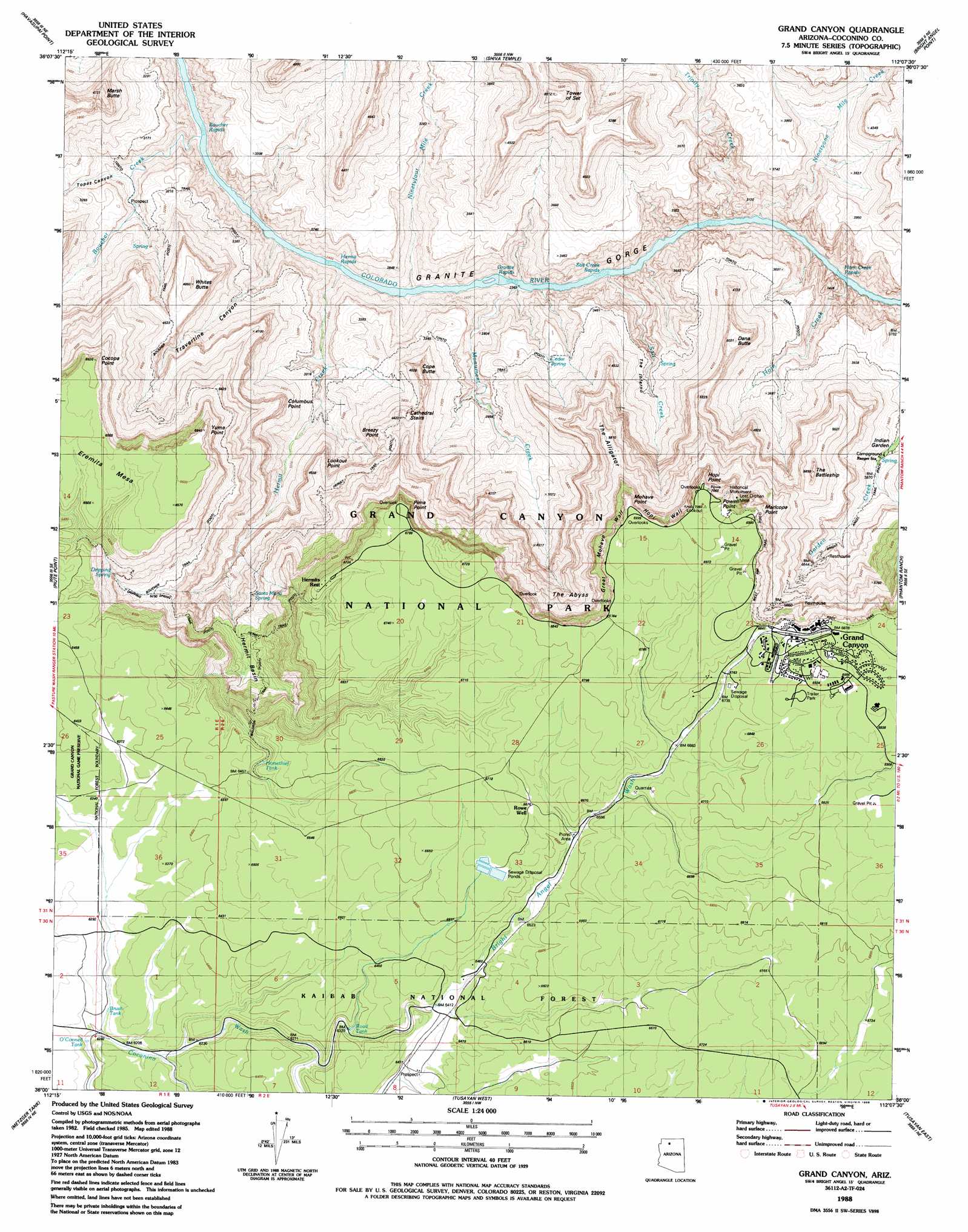
USGS Topo Quad 36112a2 - 1:24,000 scale
| Topo Map Name: | Grand Canyon |
| USGS Topo Quad ID: | 36112a2 |
| Print Size: | ca. 21 1/4" wide x 27" high |
| Southeast Coordinates: | 36° N latitude / 112.125° W longitude |
| Map Center Coordinates: | 36.0625° N latitude / 112.1875° W longitude |
| U.S. State: | AZ |
| Filename: | o36112a2.jpg |
| Download Map JPG Image: | Grand Canyon topo map 1:24,000 scale |
| Map Type: | Topographic |
| Topo Series: | 7.5´ |
| Map Scale: | 1:24,000 |
| Source of Map Images: | United States Geological Survey (USGS) |
| Alternate Map Versions: |
Grand Canyon AZ 1988, updated 1988 Download PDF Buy paper map Grand Canyon AZ 1988, updated 1988 Download PDF Buy paper map Grand Canyon AZ 2012 Download PDF Buy paper map Grand Canyon AZ 2014 Download PDF Buy paper map |
| FStopo: | US Forest Service topo Grand Canyon is available: Download FStopo PDF Download FStopo TIF |
1:24,000 Topo Quads surrounding Grand Canyon
Powell Plateau |
King Arthur Castle |
Kanabownits Spring |
Little Park Lake |
Point Imperial |
Explorers Monument |
Havasupai Point |
Shiva Temple |
Bright Angel Point |
Walhalla Plateau |
Chamisa Tank |
Piute Point |
Grand Canyon |
Phantom Ranch |
Cape Royal |
Box K Ranch |
Metzger Tank |
Tusayan West |
Tusayan East |
Grandview Point |
Little Harpo Canyon |
Howard Hill |
Red Butte Sw |
Red Butte |
Harbison Tank |
> Back to 36112a1 at 1:100,000 scale
> Back to 36112a1 at 1:250,000 scale
> Back to U.S. Topo Maps home
Grand Canyon topo map: Gazetteer
Grand Canyon: Basins
Hermit Basin elevation 1637m 5370′Grand Canyon: Cliffs
Breezy Point elevation 1346m 4416′Cathedral Stairs elevation 1360m 4461′
Cocopa Point elevation 2020m 6627′
Columbus Point elevation 1377m 4517′
Great Mohave Wall elevation 1979m 6492′
Hopi Point elevation 1951m 6400′
Hopi Wall elevation 2107m 6912′
Lookout Point elevation 1384m 4540′
Maricopa Point elevation 2089m 6853′
Mohave Point elevation 2130m 6988′
Pima Point elevation 2004m 6574′
Powell Point elevation 1827m 5994′
The Abyss elevation 1561m 5121′
The Alligator elevation 1760m 5774′
The Inferno elevation 1269m 4163′
Yuma Point elevation 2019m 6624′
Grand Canyon: Mines
Lost Orphan Mine elevation 2130m 6988′Grand Canyon: Parks
Grand Canyon National Park elevation 2095m 6873′Rowe Well Picnic Area elevation 2010m 6594′
Grand Canyon: Populated Places
Grand Canyon elevation 2099m 6886′Grand Canyon: Rapids
Boucher Rapids elevation 714m 2342′Granite Rapids elevation 719m 2358′
Hermit Rapids elevation 714m 2342′
Horn Creek Rapids elevation 730m 2395′
Salt Creek Rapids elevation 0m 0′
Grand Canyon: Reservoirs
Brush Tank elevation 1901m 6236′Horsethief Tank elevation 1964m 6443′
O'Connell Tank elevation 1887m 6190′
Road Tank elevation 1938m 6358′
Rowes Tank elevation 2028m 6653′
Sewer Number One Tank elevation 2012m 6601′
Sewer Number Two Tank elevation 2011m 6597′
Trap Tank elevation 1014m 3326′
Grand Canyon: Springs
Cedar Spring elevation 1022m 3353′Dripping Spring elevation 1737m 5698′
Fourmile Spring elevation 1333m 4373′
Santa Maria Spring elevation 0m 0′
Grand Canyon: Streams
Boucher Creek elevation 718m 2355′Bright Angel Wash elevation 1912m 6272′
Hermit Creek elevation 721m 2365′
Horn Creek elevation 862m 2828′
Monument Creek elevation 728m 2388′
Ninetyfour Mile Creek elevation 716m 2349′
Ninetyone Mile Creek elevation 726m 2381′
Salt Creek elevation 0m 0′
Trinity Creek elevation 725m 2378′
Grand Canyon: Summits
Cope Butte elevation 1374m 4507′Dana Butte elevation 1513m 4963′
Eremita Mesa elevation 1985m 6512′
Marsh Butte elevation 1432m 4698′
The Battleship elevation 1779m 5836′
Tower of Set elevation 1823m 5980′
Whites Butte elevation 1461m 4793′
Grand Canyon: Trails
Boucher Trail elevation 1802m 5912′Bright Angel Trail elevation 1257m 4124′
Dripping Springs Trail elevation 1633m 5357′
Hermit Trail elevation 1502m 4927′
Waldron Trail elevation 1678m 5505′
West Rim Trail elevation 2056m 6745′
Grand Canyon: Valleys
Topaz Canyon elevation 819m 2687′Travertine Canyon elevation 716m 2349′
Grand Canyon: Wells
Rowes Well elevation 0m 0′Grand Canyon digital topo map on disk
Buy this Grand Canyon topo map showing relief, roads, GPS coordinates and other geographical features, as a high-resolution digital map file on DVD: