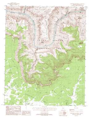
Explorers Monument Topo Map Arizona
To zoom in, hover over the map of Explorers Monument
USGS Topo Quad 36112b4 - 1:24,000 scale
| Topo Map Name: | Explorers Monument |
| USGS Topo Quad ID: | 36112b4 |
| Print Size: | ca. 21 1/4" wide x 27" high |
| Southeast Coordinates: | 36.125° N latitude / 112.375° W longitude |
| Map Center Coordinates: | 36.1875° N latitude / 112.4375° W longitude |
| U.S. State: | AZ |
| Filename: | o36112b4.jpg |
| Download Map JPG Image: | Explorers Monument topo map 1:24,000 scale |
| Map Type: | Topographic |
| Topo Series: | 7.5´ |
| Map Scale: | 1:24,000 |
| Source of Map Images: | United States Geological Survey (USGS) |
| Alternate Map Versions: |
Explorers Monument AZ 1988, updated 1988 Download PDF Buy paper map Explorers Monument AZ 2012 Download PDF Buy paper map Explorers Monument AZ 2014 Download PDF Buy paper map |
| FStopo: | US Forest Service topo Explorers Monument is available: Download FStopo PDF Download FStopo TIF |
1:24,000 Topo Quads surrounding Explorers Monument
> Back to 36112a1 at 1:100,000 scale
> Back to 36112a1 at 1:250,000 scale
> Back to U.S. Topo Maps home
Explorers Monument topo map: Gazetteer
Explorers Monument: Arches
Royal Arch elevation 937m 3074′Explorers Monument: Basins
Aztec Amphitheater elevation 1214m 3982′Evolution Amphitheater elevation 1139m 3736′
Explorers Monument: Benches
Apache Terrace elevation 1479m 4852′De Vaca Terrace elevation 1489m 4885′
Marcos Terrace elevation 1458m 4783′
Spencer Terrace elevation 1605m 5265′
Explorers Monument: Cliffs
Apache Point elevation 1918m 6292′Centeotl Point elevation 1669m 5475′
Chemehuevi Point elevation 1858m 6095′
Montezuma Point elevation 1834m 6017′
Point Centeotl elevation 1874m 6148′
Point Huitzil elevation 1848m 6062′
Point Quetzal elevation 1622m 5321′
Toltec Point elevation 1864m 6115′
Explorers Monument: Gaps
Conquistador Aisle elevation 647m 2122′Stephen Aisle elevation 652m 2139′
Explorers Monument: Plains
Darwin Plateau elevation 1638m 5374′Drummond Plateau elevation 1388m 4553′
Explorers Monument: Rapids
Hakatai Rapids elevation 712m 2335′Walthenberg Rapids elevation 657m 2155′
Explorers Monument: Reservoirs
Hidden Log Tank elevation 1839m 6033′Little Jim Tank elevation 1913m 6276′
Mexican Jack Tank elevation 1842m 6043′
Explorers Monument: Springs
Mystic Spring elevation 1476m 4842′Seep Spring elevation 0m 0′
Explorers Monument: Streams
Hundred and Twenty Mile Creek elevation 652m 2139′Royal Arch Creek elevation 0m 0′
Explorers Monument: Summits
Explorers Monument elevation 1375m 4511′Fiske Butte elevation 1430m 4691′
Mount Huethawali elevation 1895m 6217′
Explorers Monument: Valleys
Blacktail Canyon elevation 652m 2139′Elves Chasm elevation 689m 2260′
Garnet Canyon elevation 688m 2257′
Hakatai Canyon elevation 677m 2221′
Walthenberg Canyon elevation 661m 2168′
Explorers Monument digital topo map on disk
Buy this Explorers Monument topo map showing relief, roads, GPS coordinates and other geographical features, as a high-resolution digital map file on DVD:


