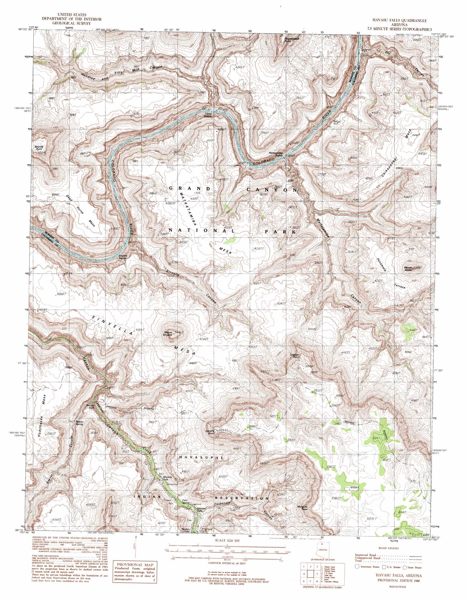
Havasu Falls Topo Map Arizona
To zoom in, hover over the map of Havasu Falls
USGS Topo Quad 36112c6 - 1:24,000 scale
| Topo Map Name: | Havasu Falls |
| USGS Topo Quad ID: | 36112c6 |
| Print Size: | ca. 21 1/4" wide x 27" high |
| Southeast Coordinates: | 36.25° N latitude / 112.625° W longitude |
| Map Center Coordinates: | 36.3125° N latitude / 112.6875° W longitude |
| U.S. State: | AZ |
| Filename: | o36112c6.jpg |
| Download Map JPG Image: | Havasu Falls topo map 1:24,000 scale |
| Map Type: | Topographic |
| Topo Series: | 7.5´ |
| Map Scale: | 1:24,000 |
| Source of Map Images: | United States Geological Survey (USGS) |
| Alternate Map Versions: |
Havasu Falls AZ 1988, updated 1988 Download PDF Buy paper map Havasu Falls AZ 2011 Download PDF Buy paper map Havasu Falls AZ 2014 Download PDF Buy paper map |
1:24,000 Topo Quads surrounding Havasu Falls
Heaton Knolls |
Robinson Canyon |
Grama Spring |
Jumpup Point |
Sowats Spring |
Hancock Knolls |
Hitson Tank |
Kanab Point |
Fishtail Mesa |
Tapeats Amphitheater |
Fern Glen Canyon |
S B Point |
Havasu Falls |
Fossil Bay |
Powell Plateau |
Gateway Rapids |
Yunosi Point |
Supai |
Topocoba Hilltop |
Explorers Monument |
National Canyon Sw |
Higgins Tank |
Driftwood Canyon |
Antelope Point |
Chamisa Tank |
> Back to 36112a1 at 1:100,000 scale
> Back to 36112a1 at 1:250,000 scale
> Back to U.S. Topo Maps home
Havasu Falls topo map: Gazetteer
Havasu Falls: Benches
Panameta Terrace elevation 1327m 4353′Havasu Falls: Cliffs
Boysag Point elevation 1601m 5252′Boysag Rim elevation 1572m 5157′
Mulgullo Point elevation 1651m 5416′
Towago Point elevation 1745m 5725′
Uqualla Point elevation 1768m 5800′
Havasu Falls: Falls
Beaver Falls elevation 787m 2582′Havasu Falls elevation 891m 2923′
Mooney Falls elevation 912m 2992′
Havasu Falls: Rapids
Matkatamiba Rapids elevation 572m 1876′Sinyella Rapids elevation 554m 1817′
Upset Rapids elevation 561m 1840′
Havasu Falls: Springs
Beaver Spring elevation 853m 2798′Havasu Falls: Summits
Chikapanagi Mesa elevation 1351m 4432′Dead Horse Mesa elevation 1225m 4019′
Matkatamiba Mesa elevation 1281m 4202′
Mount Akaba elevation 1532m 5026′
Mount Sinyella elevation 1647m 5403′
Sinyella Mesa elevation 1258m 4127′
Yumtheska Mesa elevation 1232m 4041′
Havasu Falls: Valleys
Beaver Canyon elevation 739m 2424′Matkatamiba Canyon elevation 584m 1916′
Olo Canyon elevation 612m 2007′
Sinyella Canyon elevation 587m 1925′
Havasu Falls digital topo map on disk
Buy this Havasu Falls topo map showing relief, roads, GPS coordinates and other geographical features, as a high-resolution digital map file on DVD: