S B Point Topo Map Arizona
To zoom in, hover over the map of S B Point
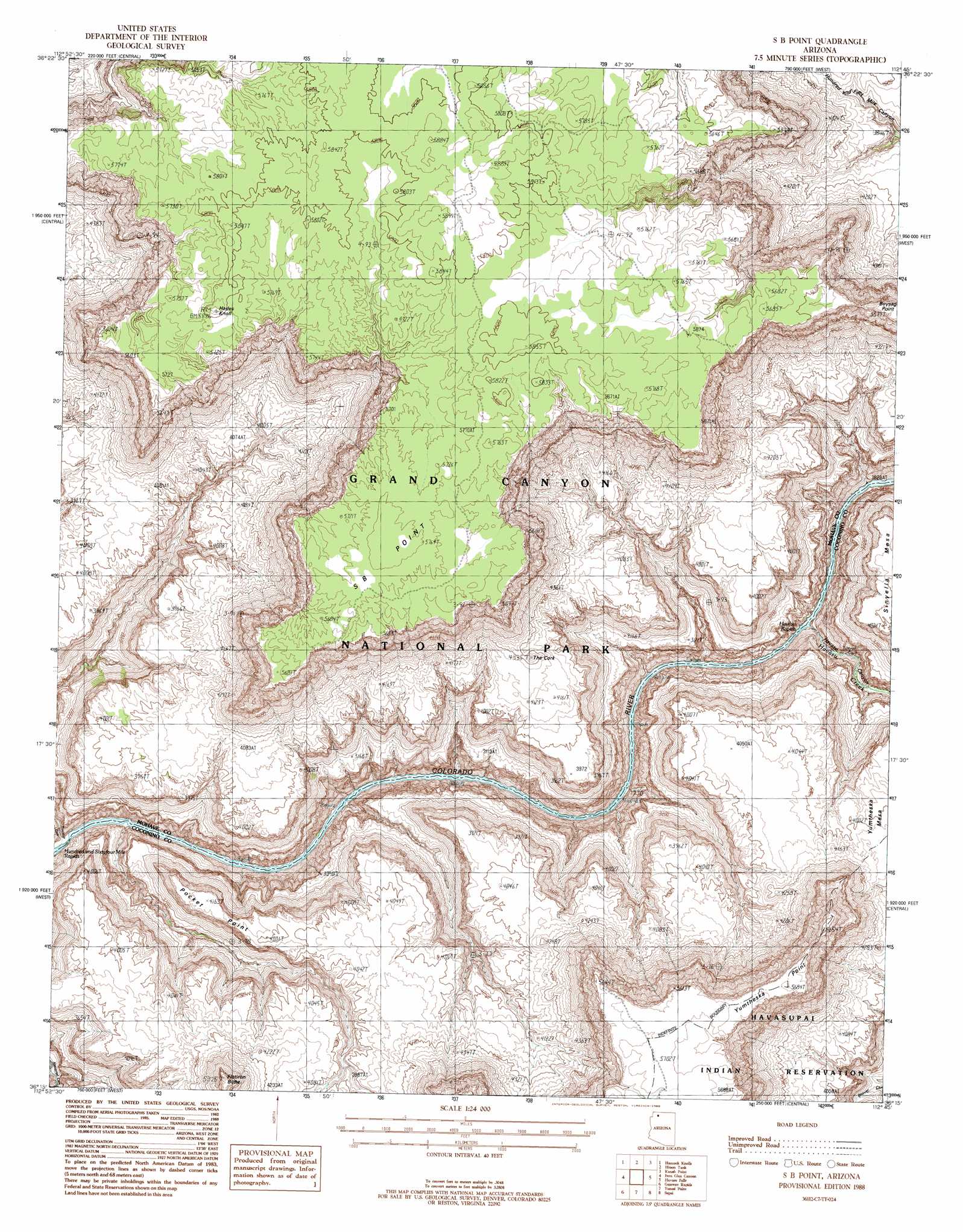
USGS Topo Quad 36112c7 - 1:24,000 scale
| Topo Map Name: | S B Point |
| USGS Topo Quad ID: | 36112c7 |
| Print Size: | ca. 21 1/4" wide x 27" high |
| Southeast Coordinates: | 36.25° N latitude / 112.75° W longitude |
| Map Center Coordinates: | 36.3125° N latitude / 112.8125° W longitude |
| U.S. State: | AZ |
| Filename: | o36112c7.jpg |
| Download Map JPG Image: | S B Point topo map 1:24,000 scale |
| Map Type: | Topographic |
| Topo Series: | 7.5´ |
| Map Scale: | 1:24,000 |
| Source of Map Images: | United States Geological Survey (USGS) |
| Alternate Map Versions: |
S B Point AZ 1988, updated 1988 Download PDF Buy paper map S B Point AZ 1988, updated 1988 Download PDF Buy paper map S B Point AZ 2011 Download PDF Buy paper map S B Point AZ 2014 Download PDF Buy paper map |
1:24,000 Topo Quads surrounding S B Point
Hat Knoll |
Heaton Knolls |
Robinson Canyon |
Grama Spring |
Jumpup Point |
Mount Trumbull Ne |
Hancock Knolls |
Hitson Tank |
Kanab Point |
Fishtail Mesa |
Mount Trumbull Se |
Fern Glen Canyon |
S B Point |
Havasu Falls |
Fossil Bay |
Vulcans Throne |
Gateway Rapids |
Yunosi Point |
Supai |
Topocoba Hilltop |
Vulcans Throne Se |
National Canyon Sw |
Higgins Tank |
Driftwood Canyon |
Antelope Point |
> Back to 36112a1 at 1:100,000 scale
> Back to 36112a1 at 1:250,000 scale
> Back to U.S. Topo Maps home
S B Point topo map: Gazetteer
S B Point: Arches
Boysag Point Arch elevation 1665m 5462′S B Point: Cliffs
Pocket Point elevation 1190m 3904′S B Point elevation 0m 0′
Yumtheska Point elevation 1722m 5649′
S B Point: Rapids
Havasu Rapids elevation 571m 1873′S B Point: Springs
Cork Spring elevation 1208m 3963′Hotel Spring elevation 1157m 3795′
Little Joe Spring elevation 1131m 3710′
S B Point: Streams
Havasu Creek elevation 638m 2093′S B Point: Summits
Flatiron Butte elevation 1608m 5275′Hades Knoll elevation 1793m 5882′
The Cork elevation 1306m 4284′
S B Point: Valleys
Havasu Canyon elevation 638m 2093′S B Point digital topo map on disk
Buy this S B Point topo map showing relief, roads, GPS coordinates and other geographical features, as a high-resolution digital map file on DVD: