House Rock Topo Map Arizona
To zoom in, hover over the map of House Rock
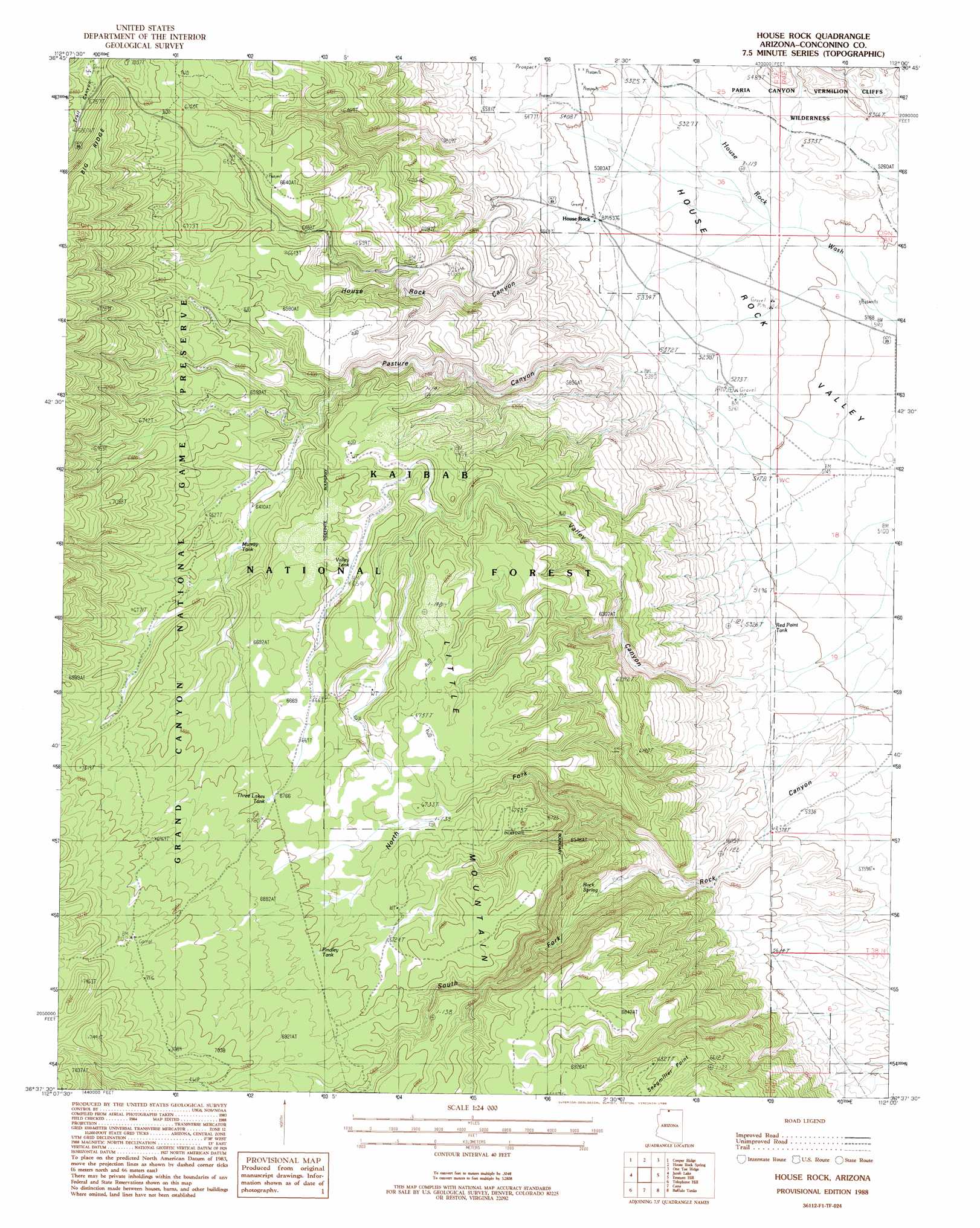
USGS Topo Quad 36112f1 - 1:24,000 scale
| Topo Map Name: | House Rock |
| USGS Topo Quad ID: | 36112f1 |
| Print Size: | ca. 21 1/4" wide x 27" high |
| Southeast Coordinates: | 36.625° N latitude / 112° W longitude |
| Map Center Coordinates: | 36.6875° N latitude / 112.0625° W longitude |
| U.S. State: | AZ |
| Filename: | o36112f1.jpg |
| Download Map JPG Image: | House Rock topo map 1:24,000 scale |
| Map Type: | Topographic |
| Topo Series: | 7.5´ |
| Map Scale: | 1:24,000 |
| Source of Map Images: | United States Geological Survey (USGS) |
| Alternate Map Versions: |
House Rock AZ 1988, updated 1988 Download PDF Buy paper map House Rock AZ 2012 Download PDF Buy paper map House Rock AZ 2014 Download PDF Buy paper map |
| FStopo: | US Forest Service topo House Rock is available: Download FStopo PDF Download FStopo TIF |
1:24,000 Topo Quads surrounding House Rock
Muggins Flat |
Buck Pasture Canyon |
Coyote Buttes |
Poverty Flat |
Wrather Arch |
Le Fevre Ridge |
Cooper Ridge |
House Rock Spring |
One Toe Ridge |
The Big Knoll |
Warm Springs Canyon |
Jacob Lake |
House Rock |
Emmett Hill |
Emmett Wash |
Big Springs |
Telephone Hill |
Cane |
Buffalo Tanks |
North Canyon Point |
Timp Point |
De Motte Park |
Dog Point |
Buffalo Ranch |
Tatahatso Point |
> Back to 36112e1 at 1:100,000 scale
> Back to 36112a1 at 1:250,000 scale
> Back to U.S. Topo Maps home
House Rock topo map: Gazetteer
House Rock: Reservoirs
Findley Tank elevation 2075m 6807′House Rock Trick Tank elevation 1991m 6532′
Murray Tank elevation 1971m 6466′
Murray Trick Tank elevation 1990m 6528′
Red Point Tank elevation 1600m 5249′
Rock Canyon Trick Tank elevation 2060m 6758′
South Rock Tank elevation 2120m 6955′
Three Lakes Tank elevation 2066m 6778′
Valley Tank elevation 1997m 6551′
House Rock: Springs
Rock Spring elevation 1794m 5885′House Rock: Valleys
House Rock Canyon elevation 1659m 5442′North Fork Rock Canyon elevation 1705m 5593′
Pasture Canyon elevation 1656m 5433′
South Fork Rock Canyon elevation 1705m 5593′
House Rock digital topo map on disk
Buy this House Rock topo map showing relief, roads, GPS coordinates and other geographical features, as a high-resolution digital map file on DVD: