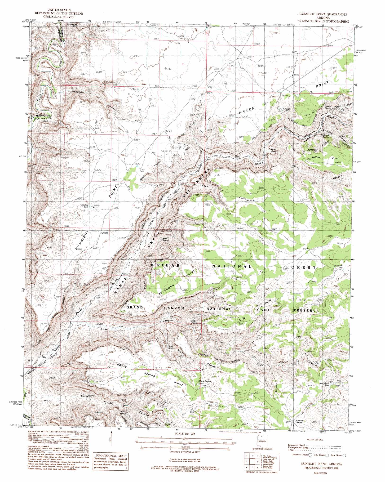
Gunsight Point Topo Map Arizona
To zoom in, hover over the map of Gunsight Point
USGS Topo Quad 36112f5 - 1:24,000 scale
| Topo Map Name: | Gunsight Point |
| USGS Topo Quad ID: | 36112f5 |
| Print Size: | ca. 21 1/4" wide x 27" high |
| Southeast Coordinates: | 36.625° N latitude / 112.5° W longitude |
| Map Center Coordinates: | 36.6875° N latitude / 112.5625° W longitude |
| U.S. State: | AZ |
| Filename: | o36112f5.jpg |
| Download Map JPG Image: | Gunsight Point topo map 1:24,000 scale |
| Map Type: | Topographic |
| Topo Series: | 7.5´ |
| Map Scale: | 1:24,000 |
| Source of Map Images: | United States Geological Survey (USGS) |
| Alternate Map Versions: |
Gunsight Point AZ 1988, updated 1988 Download PDF Buy paper map Gunsight Point AZ 2012 Download PDF Buy paper map Gunsight Point AZ 2014 Download PDF Buy paper map |
| FStopo: | US Forest Service topo Gunsight Point is available: Download FStopo PDF Download FStopo TIF |
1:24,000 Topo Quads surrounding Gunsight Point
Moccasin |
Kaibab |
Fredonia |
Shinarump Point |
Muggins Flat |
Pipe Valley |
Pipe Spring |
Clear Water Spring |
White Sage Flat |
Le Fevre Ridge |
Sunshine Ridge |
Findlay Tank |
Gunsight Point |
Toothpick Ridge |
Warm Springs Canyon |
Robinson Canyon |
Grama Spring |
Jumpup Point |
Sowats Spring |
Big Springs |
Hitson Tank |
Kanab Point |
Fishtail Mesa |
Tapeats Amphitheater |
Timp Point |
> Back to 36112e1 at 1:100,000 scale
> Back to 36112a1 at 1:250,000 scale
> Back to U.S. Topo Maps home
Gunsight Point topo map: Gazetteer
Gunsight Point: Capes
Slide Point elevation 1725m 5659′Gunsight Point: Cliffs
Buckhorn Point elevation 1655m 5429′Gunsight Point elevation 1615m 5298′
Horse Spring Point elevation 1636m 5367′
Pigeon Point elevation 1642m 5387′
Rock Canyon Point elevation 1519m 4983′
Willow Point elevation 1721m 5646′
Gunsight Point: Mines
Pigeon Mine elevation 1589m 5213′Gunsight Point: Reservoirs
Buckhorn Tank elevation 1757m 5764′Gunsight Tank elevation 1592m 5223′
Horse Spring Trick Tank elevation 1709m 5606′
Horsespring Tank elevation 1719m 5639′
Slide Elbow Tank elevation 1713m 5620′
Swapp Tank elevation 1591m 5219′
Gunsight Point: Springs
Horse Spring elevation 1474m 4835′Little Spring elevation 1476m 4842′
Pigeon Spring elevation 1488m 4881′
Rock Spring elevation 1334m 4376′
Slide Spring elevation 1479m 4852′
Wildband Spring elevation 1554m 5098′
Willow Spring elevation 1480m 4855′
Gunsight Point: Summits
Jumpup Divide elevation 1797m 5895′Gunsight Point: Valleys
Gunsight Canyon elevation 1225m 4019′Horse Canyon elevation 1387m 4550′
Little Spring Canyon elevation 1167m 3828′
Pigeon Canyon elevation 1538m 5045′
Rock Canyon elevation 1330m 4363′
Slide Canyon elevation 1211m 3973′
Snake Gulch elevation 1148m 3766′
Wildband Canyon elevation 1486m 4875′
Willow Canyon elevation 1415m 4642′
Gunsight Point digital topo map on disk
Buy this Gunsight Point topo map showing relief, roads, GPS coordinates and other geographical features, as a high-resolution digital map file on DVD: