Buck Pasture Canyon Topo Map Arizona
To zoom in, hover over the map of Buck Pasture Canyon
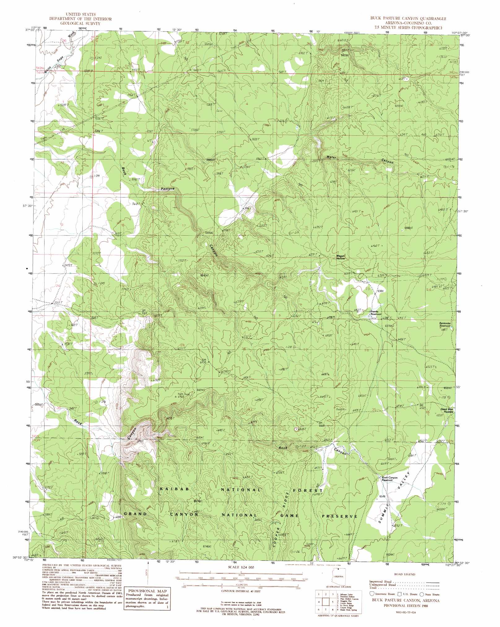
USGS Topo Quad 36112h2 - 1:24,000 scale
| Topo Map Name: | Buck Pasture Canyon |
| USGS Topo Quad ID: | 36112h2 |
| Print Size: | ca. 21 1/4" wide x 27" high |
| Southeast Coordinates: | 36.875° N latitude / 112.125° W longitude |
| Map Center Coordinates: | 36.9375° N latitude / 112.1875° W longitude |
| U.S. State: | AZ |
| Filename: | o36112h2.jpg |
| Download Map JPG Image: | Buck Pasture Canyon topo map 1:24,000 scale |
| Map Type: | Topographic |
| Topo Series: | 7.5´ |
| Map Scale: | 1:24,000 |
| Source of Map Images: | United States Geological Survey (USGS) |
| Alternate Map Versions: |
House Rock Spring NW AZ 1957, updated 1958 Download PDF Buy paper map Buck Pasture Canyon AZ 1988, updated 1988 Download PDF Buy paper map Buck Pasture Canyon AZ 2012 Download PDF Buy paper map Buck Pasture Canyon AZ 2014 Download PDF Buy paper map |
| FStopo: | US Forest Service topo Buck Pasture Canyon is available: Download FStopo PDF Download FStopo TIF |
1:24,000 Topo Quads surrounding Buck Pasture Canyon
Cutler Point |
Pine Point |
Nephi Point |
Eightmile Pass |
Fivemile Valley |
Thompson Point |
Johnson Lakes |
Petrified Hollow |
Pine Hollow Canyon |
West Clark Bench |
Shinarump Point |
Muggins Flat |
Buck Pasture Canyon |
Coyote Buttes |
Poverty Flat |
White Sage Flat |
Le Fevre Ridge |
Cooper Ridge |
House Rock Spring |
One Toe Ridge |
Toothpick Ridge |
Warm Springs Canyon |
Jacob Lake |
House Rock |
Emmett Hill |
> Back to 36112e1 at 1:100,000 scale
> Back to 36112a1 at 1:250,000 scale
> Back to U.S. Topo Maps home
Buck Pasture Canyon topo map: Gazetteer
Buck Pasture Canyon: Basins
Dead Man Pockets elevation 1988m 6522′Buck Pasture Canyon: Reservoirs
Bentonite Reservoir elevation 1977m 6486′Franks Reservoir elevation 1949m 6394′
Navajo Trait Tank elevation 2044m 6706′
Navajo Trait Trick Tank elevation 2029m 6656′
Old Arizona Catchment elevation 1708m 5603′
Rock Canyon Reservoir elevation 1997m 6551′
Shearing Shed Reservoir elevation 1975m 6479′
Summit Valley Tank elevation 1976m 6482′
Summit Valley Wildlife Apron elevation 2000m 6561′
Winter Road Catchment elevation 1948m 6391′
Buck Pasture Canyon: Summits
Buckskin Mountains elevation 1945m 6381′Buck Pasture Canyon: Trails
Kaibab Plateau Arizona Trail elevation 2021m 6630′Navajo Trail elevation 1975m 6479′
Buck Pasture Canyon: Valleys
Orderville Canyon elevation 1999m 6558′Round Valley elevation 0m 0′
Summit Valley elevation 2000m 6561′
Wagon Hollow elevation 1995m 6545′
Water Canyon elevation 1928m 6325′
Buck Pasture Canyon digital topo map on disk
Buy this Buck Pasture Canyon topo map showing relief, roads, GPS coordinates and other geographical features, as a high-resolution digital map file on DVD: