Cold Spring Topo Map Arizona
To zoom in, hover over the map of Cold Spring
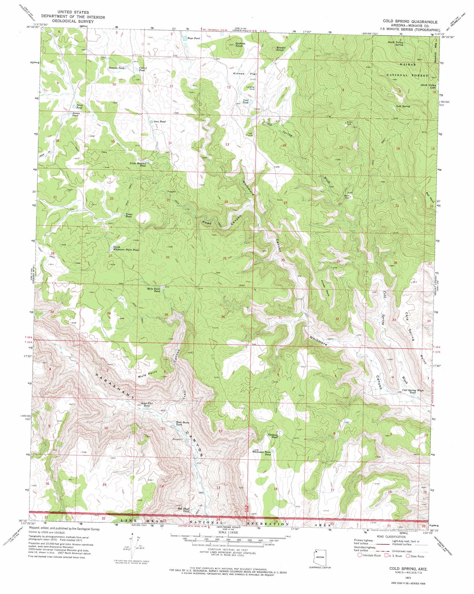
USGS Topo Quad 36113c3 - 1:24,000 scale
| Topo Map Name: | Cold Spring |
| USGS Topo Quad ID: | 36113c3 |
| Print Size: | ca. 21 1/4" wide x 27" high |
| Southeast Coordinates: | 36.25° N latitude / 113.25° W longitude |
| Map Center Coordinates: | 36.3125° N latitude / 113.3125° W longitude |
| U.S. State: | AZ |
| Filename: | o36113c3.jpg |
| Download Map JPG Image: | Cold Spring topo map 1:24,000 scale |
| Map Type: | Topographic |
| Topo Series: | 7.5´ |
| Map Scale: | 1:24,000 |
| Source of Map Images: | United States Geological Survey (USGS) |
| Alternate Map Versions: |
Cold Spring AZ 1971, updated 1974 Download PDF Buy paper map Cold Spring AZ 2011 Download PDF Buy paper map Cold Spring AZ 2014 Download PDF Buy paper map |
1:24,000 Topo Quads surrounding Cold Spring
Sullivan Draw South |
Little Tanks |
Russell Spring |
Moriah Knoll |
Hat Knoll |
Poverty Spring |
Poverty Knoll |
Jones Hill |
Mount Trumbull |
Mount Trumbull Ne |
Wildcat Ranch |
Grassy Mountain |
Cold Spring |
Mount Logan |
Mount Trumbull Se |
Castle Peak |
Yellow John Mountain |
Whitmore Point |
Whitmore Rapids |
Vulcans Throne |
Mount Dellenbaugh |
Whitmore Point Sw |
Whitmore Point Se |
Vulcans Throne Sw |
Vulcans Throne Se |
> Back to 36113a1 at 1:100,000 scale
> Back to 36112a1 at 1:250,000 scale
> Back to U.S. Topo Maps home
Cold Spring topo map: Gazetteer
Cold Spring: Cliffs
Mule Point elevation 1634m 5360′Cold Spring: Flats
Kinney Flat elevation 1621m 5318′Cold Spring: Lakes
Cold Spring Wash Pond elevation 1294m 4245′Death Valley Lake elevation 2090m 6856′
Fence Pond elevation 1611m 5285′
Little Boulder Pond elevation 1583m 5193′
Roys Pond elevation 0m 0′
Sinkhole Pond elevation 1587m 5206′
Whitmore Point Pond elevation 1592m 5223′
Cold Spring: Reservoirs
Ann Pond elevation 1595m 5232′Cold Tank elevation 1606m 5269′
Corral Pond elevation 1619m 5311′
Ditch Pond elevation 1614m 5295′
Duncan Tank elevation 1619m 5311′
James Pond elevation 1618m 5308′
Mule Point Pond elevation 1620m 5314′
North Whitmore Point Pond elevation 1620m 5314′
Red Bluff Tank elevation 1148m 3766′
Rock Basin Tank elevation 1157m 3795′
Sand Flat Tank elevation 0m 0′
Cold Spring: Springs
Cold Spring elevation 1937m 6354′Cole Spring elevation 1702m 5583′
Death Valley Spring elevation 1974m 6476′
Cold Spring: Summits
Brown Knoll elevation 1715m 5626′Cold Spring Point elevation 1536m 5039′
Griffith Knoll elevation 1696m 5564′
Kinney Point elevation 1612m 5288′
Cold Spring: Valleys
Cold Spring Wash elevation 1283m 4209′Road Canyon elevation 1475m 4839′
Trail Canyon elevation 1167m 3828′
Cold Spring digital topo map on disk
Buy this Cold Spring topo map showing relief, roads, GPS coordinates and other geographical features, as a high-resolution digital map file on DVD: