Poverty Knoll Topo Map Arizona
To zoom in, hover over the map of Poverty Knoll
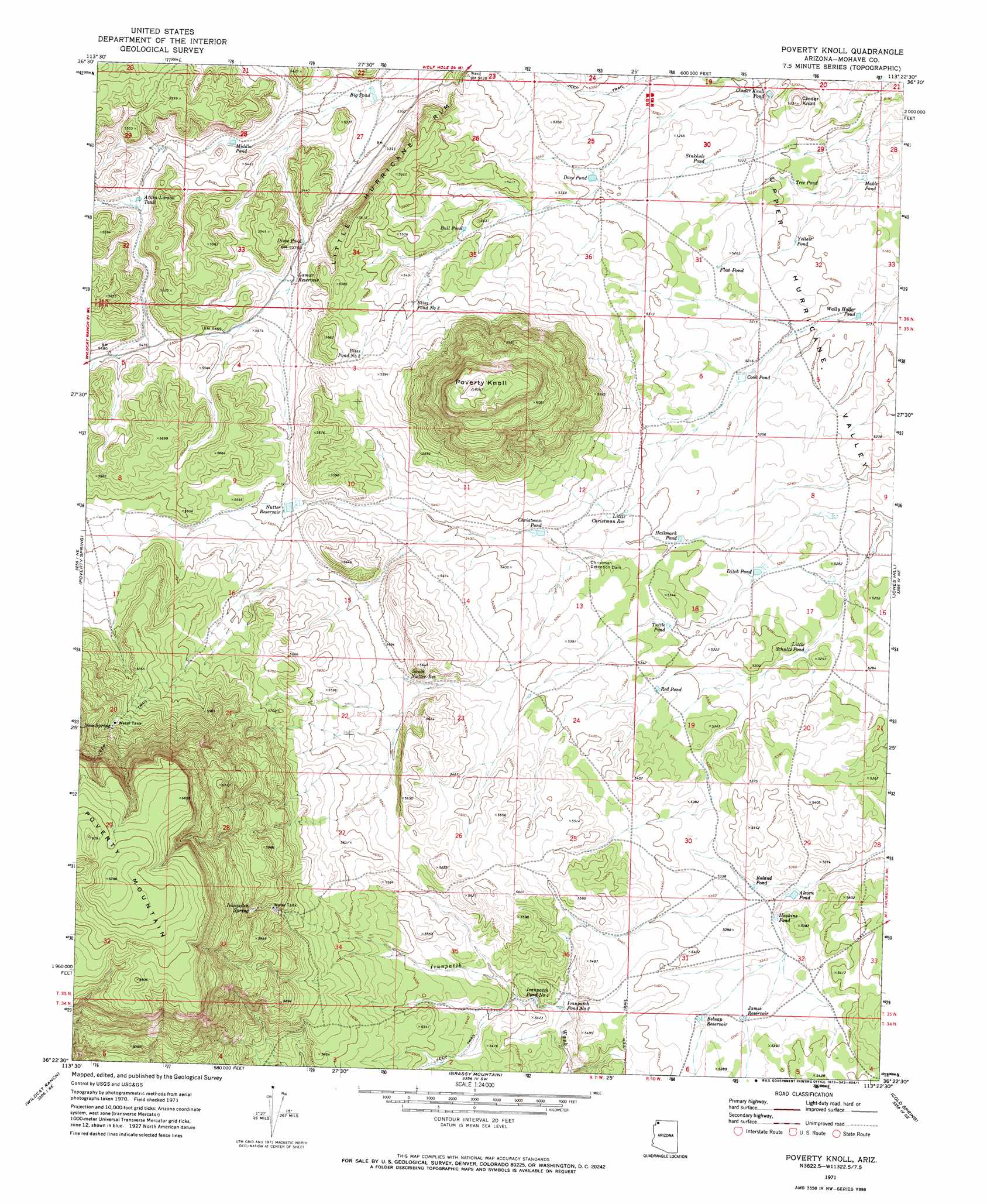
USGS Topo Quad 36113d4 - 1:24,000 scale
| Topo Map Name: | Poverty Knoll |
| USGS Topo Quad ID: | 36113d4 |
| Print Size: | ca. 21 1/4" wide x 27" high |
| Southeast Coordinates: | 36.375° N latitude / 113.375° W longitude |
| Map Center Coordinates: | 36.4375° N latitude / 113.4375° W longitude |
| U.S. State: | AZ |
| Filename: | o36113d4.jpg |
| Download Map JPG Image: | Poverty Knoll topo map 1:24,000 scale |
| Map Type: | Topographic |
| Topo Series: | 7.5´ |
| Map Scale: | 1:24,000 |
| Source of Map Images: | United States Geological Survey (USGS) |
| Alternate Map Versions: |
Poverty Knoll AZ 1971, updated 1973 Download PDF Buy paper map Poverty Knoll AZ 2011 Download PDF Buy paper map Poverty Knoll AZ 2014 Download PDF Buy paper map |
1:24,000 Topo Quads surrounding Poverty Knoll
Mustang Knoll |
Sullivan Draw North |
Dutchman Draw |
The Grandstand |
Antelope Knoll |
Saint George Canyon |
Sullivan Draw South |
Little Tanks |
Russell Spring |
Moriah Knoll |
Last Chance Canyon |
Poverty Spring |
Poverty Knoll |
Jones Hill |
Mount Trumbull |
Mustang Point |
Wildcat Ranch |
Grassy Mountain |
Cold Spring |
Mount Logan |
Snap Draw |
Castle Peak |
Yellow John Mountain |
Whitmore Point |
Whitmore Rapids |
> Back to 36113a1 at 1:100,000 scale
> Back to 36112a1 at 1:250,000 scale
> Back to U.S. Topo Maps home
Poverty Knoll topo map: Gazetteer
Poverty Knoll: Cliffs
Little Hurricane Rim elevation 1678m 5505′Poverty Knoll: Dams
Christman Detention Dam elevation 1628m 5341′Poverty Knoll: Lakes
Bliss Pond Number Three elevation 1672m 5485′Bliss Pond Number Two elevation 1688m 5538′
Bull Pond elevation 1645m 5396′
Dime Pond elevation 1639m 5377′
Flat Pond elevation 1599m 5246′
Ivanpatch Pond Number One elevation 1635m 5364′
Ivanpatch Pond Number Two elevation 1629m 5344′
Mable Pond elevation 1566m 5137′
Roland Pond elevation 1628m 5341′
Sinkhole Pond elevation 1598m 5242′
Tree Pond elevation 1578m 5177′
Tuttle Pond elevation 1620m 5314′
Yellow Pond elevation 1581m 5187′
Poverty Knoll: Reservoirs
Alcorn Pond elevation 1621m 5318′Atkin-Larson Tank elevation 1652m 5419′
Belnap Reservoir elevation 1633m 5357′
Big Pond elevation 1609m 5278′
Christman Pond elevation 1631m 5351′
Cinder Knoll Pond elevation 1580m 5183′
Cook Pond elevation 1593m 5226′
Dave Pond elevation 1613m 5291′
Ditch Pond elevation 1601m 5252′
End Trough elevation 1656m 5433′
Hallmark Pond elevation 1611m 5285′
Haskins Pond elevation 1624m 5328′
Ivanpah Spring Tank elevation 1776m 5826′
James Reservoir elevation 1631m 5351′
Jones Pond elevation 1603m 5259′
Lamar Reservoir elevation 1647m 5403′
Little Christman Reservoir elevation 1622m 5321′
Little Schultz Pond elevation 1599m 5246′
Middle Pond elevation 1631m 5351′
Nutter Reservoir elevation 1673m 5488′
Red Pond elevation 1620m 5314′
Road Pond elevation 1593m 5226′
South Nutter Reservoir elevation 1666m 5465′
Wally Holler Pond elevation 1577m 5173′
Poverty Knoll: Springs
Ivanpatch Spring elevation 1809m 5935′New Spring elevation 1830m 6003′
Poverty Knoll: Summits
Cinder Knoll elevation 1626m 5334′Poverty Knoll elevation 1930m 6332′
Poverty Mountain elevation 2068m 6784′
Poverty Knoll digital topo map on disk
Buy this Poverty Knoll topo map showing relief, roads, GPS coordinates and other geographical features, as a high-resolution digital map file on DVD: