Moriah Knoll Topo Map Arizona
To zoom in, hover over the map of Moriah Knoll
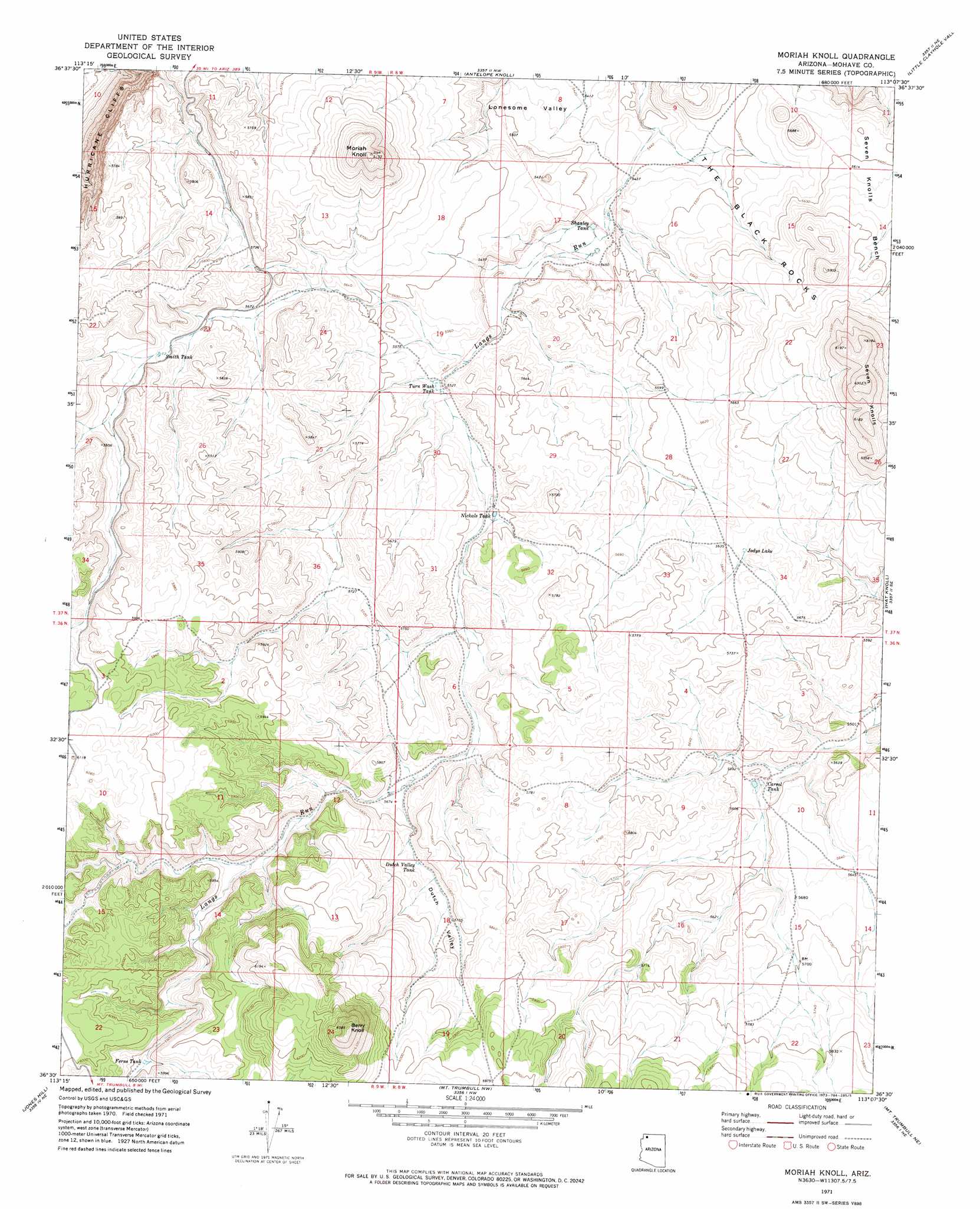
USGS Topo Quad 36113e2 - 1:24,000 scale
| Topo Map Name: | Moriah Knoll |
| USGS Topo Quad ID: | 36113e2 |
| Print Size: | ca. 21 1/4" wide x 27" high |
| Southeast Coordinates: | 36.5° N latitude / 113.125° W longitude |
| Map Center Coordinates: | 36.5625° N latitude / 113.1875° W longitude |
| U.S. State: | AZ |
| Filename: | o36113e2.jpg |
| Download Map JPG Image: | Moriah Knoll topo map 1:24,000 scale |
| Map Type: | Topographic |
| Topo Series: | 7.5´ |
| Map Scale: | 1:24,000 |
| Source of Map Images: | United States Geological Survey (USGS) |
| Alternate Map Versions: |
Moriah Knoll AZ 1971, updated 1973 Download PDF Buy paper map Moriah Knoll AZ 2011 Download PDF Buy paper map Moriah Knoll AZ 2014 Download PDF Buy paper map |
1:24,000 Topo Quads surrounding Moriah Knoll
Hole-N-Wall Canyon |
Gyp Pocket |
White Pockets |
Formaster Well |
Maroney Well |
Dutchman Draw |
The Grandstand |
Antelope Knoll |
Little Clayhole Valley |
Wild Band Pockets |
Little Tanks |
Russell Spring |
Moriah Knoll |
Hat Knoll |
Heaton Knolls |
Poverty Knoll |
Jones Hill |
Mount Trumbull |
Mount Trumbull Ne |
Hancock Knolls |
Grassy Mountain |
Cold Spring |
Mount Logan |
Mount Trumbull Se |
Fern Glen Canyon |
> Back to 36113e1 at 1:100,000 scale
> Back to 36112a1 at 1:250,000 scale
> Back to U.S. Topo Maps home
Moriah Knoll topo map: Gazetteer
Moriah Knoll: Lakes
Jodys Lake elevation 1719m 5639′Moriah Knoll: Reservoirs
Carrol Tank elevation 1695m 5561′Dutch Valley Tank elevation 1746m 5728′
Ferns Tank elevation 1795m 5889′
Langston Black Canyon Tank elevation 1677m 5501′
Nickals Tank elevation 1699m 5574′
Shanley Tank elevation 0m 0′
Smith Tank elevation 1748m 5734′
Turn Wash Tank elevation 1684m 5524′
Moriah Knoll: Springs
Hualpais Spring elevation 1733m 5685′Moriah Knoll: Summits
Berry Knoll elevation 2006m 6581′Moriah Knoll elevation 1867m 6125′
Seven Knolls elevation 0m 0′
Moriah Knoll: Valleys
Dutch Valley elevation 1731m 5679′Moriah Knoll digital topo map on disk
Buy this Moriah Knoll topo map showing relief, roads, GPS coordinates and other geographical features, as a high-resolution digital map file on DVD: