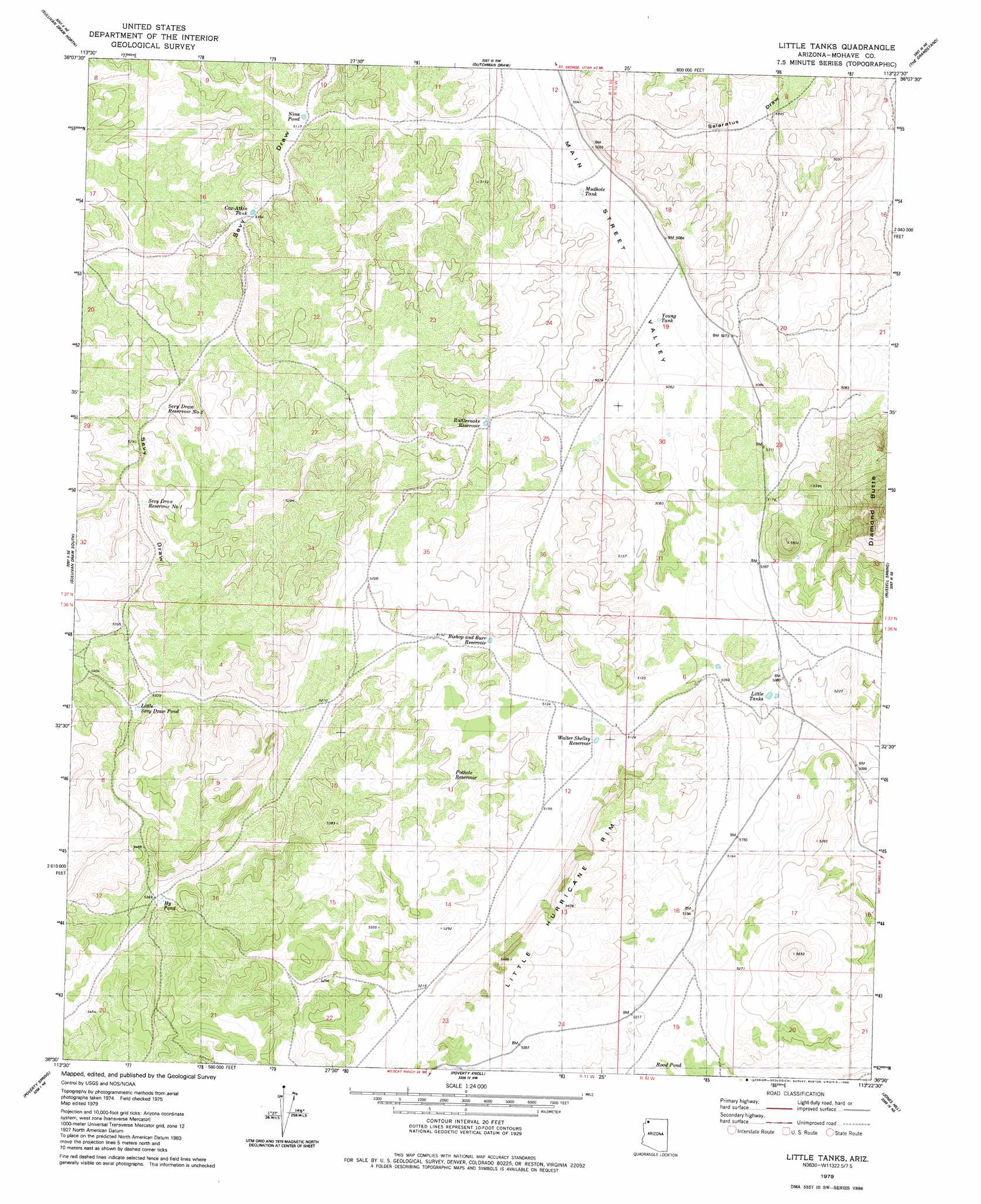
Little Tanks Topo Map Arizona
To zoom in, hover over the map of Little Tanks
USGS Topo Quad 36113e4 - 1:24,000 scale
| Topo Map Name: | Little Tanks |
| USGS Topo Quad ID: | 36113e4 |
| Print Size: | ca. 21 1/4" wide x 27" high |
| Southeast Coordinates: | 36.5° N latitude / 113.375° W longitude |
| Map Center Coordinates: | 36.5625° N latitude / 113.4375° W longitude |
| U.S. State: | AZ |
| Filename: | o36113e4.jpg |
| Download Map JPG Image: | Little Tanks topo map 1:24,000 scale |
| Map Type: | Topographic |
| Topo Series: | 7.5´ |
| Map Scale: | 1:24,000 |
| Source of Map Images: | United States Geological Survey (USGS) |
| Alternate Map Versions: |
Little Tanks AZ 2011 Download PDF Buy paper map Little Tanks AZ 2014 Download PDF Buy paper map |
1:24,000 Topo Quads surrounding Little Tanks
Wolf Hole Mountain West |
Wolf Hole Mountain East |
Hole-N-Wall Canyon |
Gyp Pocket |
White Pockets |
Mustang Knoll |
Sullivan Draw North |
Dutchman Draw |
The Grandstand |
Antelope Knoll |
Saint George Canyon |
Sullivan Draw South |
Little Tanks |
Russell Spring |
Moriah Knoll |
Last Chance Canyon |
Poverty Spring |
Poverty Knoll |
Jones Hill |
Mount Trumbull |
Mustang Point |
Wildcat Ranch |
Grassy Mountain |
Cold Spring |
Mount Logan |
> Back to 36113e1 at 1:100,000 scale
> Back to 36112a1 at 1:250,000 scale
> Back to U.S. Topo Maps home
Little Tanks topo map: Gazetteer
Little Tanks: Reservoirs
Alva Shelly Reservoir elevation 1563m 5127′Bishop and Burr Reservoir elevation 1565m 5134′
Cox Tank elevation 1575m 5167′
Cox-Atkin Tank elevation 1576m 5170′
Hy Pond elevation 1637m 5370′
Limestone Reservoir elevation 1615m 5298′
Little Sevy Draw Pond elevation 1635m 5364′
Little Tanks elevation 1551m 5088′
Mudhole Tank elevation 1539m 5049′
Nina Pond elevation 1562m 5124′
Pothole Reservoir elevation 1583m 5193′
Rattlesnake Reservoir elevation 1564m 5131′
Road Pond elevation 1598m 5242′
Sevy Draw Reservoir Number One elevation 1626m 5334′
Sevy Draw Reservoir Number Two elevation 1607m 5272′
Sinkhole Reservoir elevation 1499m 4917′
Upper Little Joe Pond elevation 1561m 5121′
Walter Shelley Reservoir elevation 1564m 5131′
Young Tank elevation 1540m 5052′
Little Tanks digital topo map on disk
Buy this Little Tanks topo map showing relief, roads, GPS coordinates and other geographical features, as a high-resolution digital map file on DVD: