Saint George Canyon Topo Map Arizona
To zoom in, hover over the map of Saint George Canyon
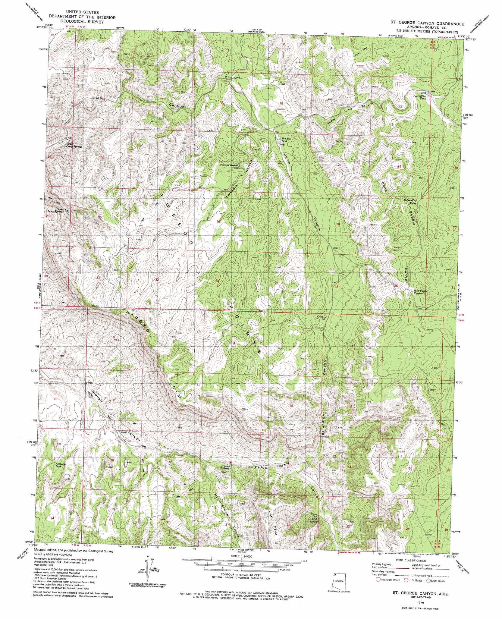
USGS Topo Quad 36113e6 - 1:24,000 scale
| Topo Map Name: | Saint George Canyon |
| USGS Topo Quad ID: | 36113e6 |
| Print Size: | ca. 21 1/4" wide x 27" high |
| Southeast Coordinates: | 36.5° N latitude / 113.625° W longitude |
| Map Center Coordinates: | 36.5625° N latitude / 113.6875° W longitude |
| U.S. State: | AZ |
| Filename: | o36113e6.jpg |
| Download Map JPG Image: | Saint George Canyon topo map 1:24,000 scale |
| Map Type: | Topographic |
| Topo Series: | 7.5´ |
| Map Scale: | 1:24,000 |
| Source of Map Images: | United States Geological Survey (USGS) |
| Alternate Map Versions: |
St. George Canyon AZ 1979, updated 1985 Download PDF Buy paper map Saint George Canyon AZ 2011 Download PDF Buy paper map Saint George Canyon AZ 2014 Download PDF Buy paper map |
1:24,000 Topo Quads surrounding Saint George Canyon
Elbow Canyon |
Mount Bangs |
Wolf Hole Mountain West |
Wolf Hole Mountain East |
Hole-N-Wall Canyon |
Jacobs Well |
Cane Springs |
Mustang Knoll |
Sullivan Draw North |
Dutchman Draw |
Red Pockets |
Cane Springs Se |
Saint George Canyon |
Sullivan Draw South |
Little Tanks |
Pakoon Springs |
Olaf Knolls |
Last Chance Canyon |
Poverty Spring |
Poverty Knoll |
Gyp Hills |
Grand Gulch Bench |
Mustang Point |
Wildcat Ranch |
Grassy Mountain |
> Back to 36113e1 at 1:100,000 scale
> Back to 36112a1 at 1:250,000 scale
> Back to U.S. Topo Maps home
Saint George Canyon topo map: Gazetteer
Saint George Canyon: Gaps
One Way Pass elevation 1652m 5419′Saint George Canyon: Mines
Hidden Mines elevation 1278m 4192′Saint George Canyon: Reservoirs
Ferguson Tank elevation 1191m 3907′Post Office Tank elevation 1562m 5124′
Shoe Buckle Reservoir elevation 0m 0′
The Bin Tank elevation 1442m 4730′
Tweedie Hollow Tank elevation 1472m 4829′
Saint George Canyon: Springs
Link Spring elevation 1409m 4622′Lower Jump Springs elevation 1384m 4540′
Upper Jump Springs elevation 1283m 4209′
Saint George Canyon: Summits
Link Point elevation 1760m 5774′Tweeds Points elevation 1600m 5249′
Saint George Canyon: Valleys
Last Chance Canyon elevation 1230m 4035′Saint George Canyon elevation 0m 0′
Shoe Buckle Canyon elevation 0m 0′
Tweedie Hollow elevation 1438m 4717′
Upper Jump Canyon elevation 1458m 4783′
Saint George Canyon digital topo map on disk
Buy this Saint George Canyon topo map showing relief, roads, GPS coordinates and other geographical features, as a high-resolution digital map file on DVD: