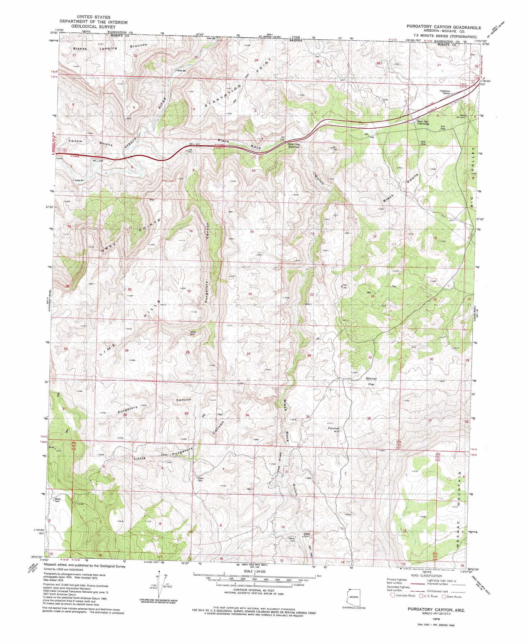
Purgatory Canyon Topo Map Arizona
To zoom in, hover over the map of Purgatory Canyon
USGS Topo Quad 36113h6 - 1:24,000 scale
| Topo Map Name: | Purgatory Canyon |
| USGS Topo Quad ID: | 36113h6 |
| Print Size: | ca. 21 1/4" wide x 27" high |
| Southeast Coordinates: | 36.875° N latitude / 113.625° W longitude |
| Map Center Coordinates: | 36.9375° N latitude / 113.6875° W longitude |
| U.S. State: | AZ |
| Filename: | o36113h6.jpg |
| Download Map JPG Image: | Purgatory Canyon topo map 1:24,000 scale |
| Map Type: | Topographic |
| Topo Series: | 7.5´ |
| Map Scale: | 1:24,000 |
| Source of Map Images: | United States Geological Survey (USGS) |
| Alternate Map Versions: |
Wolf Hole Mtn. NW AZ 1954, updated 1956 Download PDF Buy paper map Purgatory Canyon AZ 1979, updated 1980 Download PDF Buy paper map Purgatory Canyon AZ 2011 Download PDF Buy paper map Purgatory Canyon AZ 2011 Download PDF Buy paper map Purgatory Canyon AZ 2014 Download PDF Buy paper map |
1:24,000 Topo Quads surrounding Purgatory Canyon
West Mountain Peak |
Shivwits |
Santa Clara |
Washington |
Harrisburg Junction |
Castle Cliff |
Jarvis Peak |
White Hills |
Saint George |
Washington Dome |
Littlefield |
Mountain Sheep Spring |
Purgatory Canyon |
Lizard Point |
Yellowhorse Flat |
Elbow Canyon |
Mount Bangs |
Wolf Hole Mountain West |
Wolf Hole Mountain East |
Hole-N-Wall Canyon |
Jacobs Well |
Cane Springs |
Mustang Knoll |
Sullivan Draw North |
Dutchman Draw |
> Back to 36113e1 at 1:100,000 scale
> Back to 36112a1 at 1:250,000 scale
> Back to U.S. Topo Maps home
Purgatory Canyon topo map: Gazetteer
Purgatory Canyon: Arches
Shivwits Arch elevation 1016m 3333′Purgatory Canyon: Areas
Blakes Lambing Grounds elevation 1218m 3996′Purgatory Canyon: Cliffs
Grey Points elevation 1204m 3950′Starvation Point elevation 1041m 3415′
The Dives elevation 1056m 3464′
Purgatory Canyon: Crossings
Black Rock Interchange elevation 853m 2798′Purgatory Canyon: Flats
Dinner Flat elevation 1084m 3556′Purgatory Canyon: Reservoirs
State Line Reservoir elevation 821m 2693′Purgatory Canyon: Ridges
Lime Hills elevation 1372m 4501′Purgatory Canyon: Summits
Black Knolls elevation 1092m 3582′Mokaac Mountain elevation 1578m 5177′
Pocket Hill elevation 1160m 3805′
Yellow Knolls elevation 810m 2657′
Purgatory Canyon: Valleys
Black Rock Gulch elevation 715m 2345′Little Purgatory Canyon elevation 1010m 3313′
Purgatory Canyon elevation 775m 2542′
Purgatory Canyon digital topo map on disk
Buy this Purgatory Canyon topo map showing relief, roads, GPS coordinates and other geographical features, as a high-resolution digital map file on DVD: